Issue Date: Friday, August 30th, 2019
Issue Time: 9:35AM MDT
— A LOW flood threat has been issued for the southern Urban Corridor, Palmer Ridge, Northeast Plains, Southeast Plains, Raton Ridge, Southeast Mountains, Junkins burn area and the Spring Creek burn area
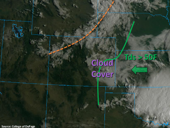
Taking a look at the visible satellite imagery below, there are a couple of noteworthy features. First, the next shortwave can be seen along the dashed orange line. As upper level flow changes from westerly to northwesterly, expect this feature to arrive to the Northeast Plains this afternoon, which will help aid in shower and thunderstorm development. The second noteworthy feature is the cloud cover over the eastern plains, which indicates higher values of moisture have returned to the area. In fact, dew points over the Southeast Plains are already greater than 50°F, which is marked by the green solid line below. PW this morning at Denver was measured at 0.81 inches, which is quite the increase from the last couple of days. Throughout the day, southeasterly and easterly surface flow will reinforce and strengthen the low level moisture over the eastern plains. This will combat westerly flow aloft that will mix out moisture from west to east off the eastern high terrains. Thus, the heavy rainfall threat will mostly be east of I-25. The one exception is near the Wet and southern Southeast Mountains where stronger easterly surface flow will advect in higher moisture. Rain rates will be high enough to cause flash flooding issues over the Spring Creek and Junkins burn areas if a storm tracks overhead, so these scars are included in the Low flood threat.
With decent shear and CAPE in place, some isolated severe thunderstorms will be possible over the eastern plains where the cap can break. Storms this afternoon are forecast to be more scattered in nature due to the stability, but severe hail and damaging winds will be possible with a couple of the storms that are able to develop. Storm motion is forecast to the southeast at 10 to 15 mph, so local heavy rainfall is forecast, too, with the pulse-like storms. Note, there is a second wave of storms possible over the far northeast corner between 8 and 11PM that move in from the Nebraska panhandle, and if the cap can break, these storms will also be heavy rainfall producers. Thus, the low threat has been extended to the northeast corner.
Back to the west, dry thunderstorms are forecast again with the best chances for storms over the high terrains near and along the Continental Divide. PW at Grand Junction was measured at 0.72 inches with a lot of moisture above 600mb. So, there is enough moisture that critical fire weather should not be realized, but surface accumulations will remain light with the best chance for measurable rainfall over the Northern Mountains. Storms should end statewide around midnight.
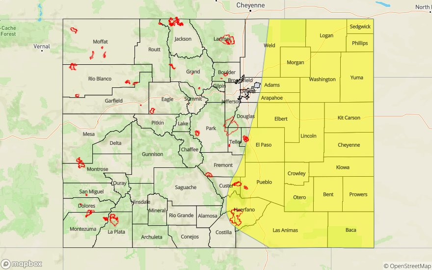
Today’s Flood Threat Map
For more information on today’s flood threat, see the map below. For Zone-Specific forecasts, scroll below the map.

Zone-Specific Forecasts:
Front Range, Southeast Mountains, Urban Corridor, Northeast Plains, Palmer Ridge, Raton Ridge, Southeast Plains:
Plenty of action today thanks the approaching shortwave helping break the cap. Severe thunderstorms over the eastern plains will be capable of producing up to 1.25 inch hail and strong gusts (the main threat). In the Low flood threat area, max 1-hour rain rates up to 1.25 inches (west) and 1.8 inches (east) will be possible. Flash flooding is also possible over the Spring Creek and Junkins burn areas as there is moderate confidence all storms in the area will be capable of producing 1-hour rain rates greater than 0.50 inches and up to 0.75 inches. Flood threats over the burn areas include flash flooding of local streams, debris slides and mud flows. Flood threats over the eastern plains include field ponding, road flooding, local stream flash flooding and arroyo flooding (Southeast Plains). Lower rain rates (up to 0.6 inches) will be possible for storms that form over the Front Range and Southeast Mountains with the post frontal upslope flow. A Low flood threat has been issued due to the more isolated nature of the heavy rainfall producing storms this afternoon.
Primetime: 1:30PM to Midnight
Northwest Slope, Grand Valley, Southwest Slope, Northern Mountains, Central Mountains, San Juan Mountains, San Luis Valley:
A little bit of cloud cover where the shortwave is overhead this morning. An increase in moisture should limit the critical fire weather this afternoon, but dry thunderstorms will still be possible as well as gusty outflow winds. Best chances for measurable rainfall this afternoon will be over the Northern Mountains where isolated storm totals up to 0.2 inches will be possible. Flooding is not forecast.
Primetime: 1PM to 9PM