Issue Date: Thursday, August 29th, 2019
Issue Time: 9:25AM MDT
Relatively busy water vapor imagery below compared to the last couple of days. The subtropical high will move to the east throughout the day as a couple shortwaves move through the state with westerly (western CO) and northwesterly (eastern CO) upper level flow. Higher PW values continue to stay to our south and east in this setup, although moisture slightly recovers with the passing disturbances. PW was measured at 0.42 inches and 0.52 inches at Denver and Grand Junction, respectively. For western Colorado, this means some weak showers and dry thunderstorms may be possible over the higher terrains as the shortwave over Utah (marked below) shifts west and enhances upslope flow. Most storms are expected to produce gusty outflow winds rather than measurable rainfall. The main threat will be dangerous cloud-to-ground lightning in a low relative humidity environment with 10 to 15 mph sustained southwest surface winds. A Red Flag Warning has been issued for the Northwest Slope through 9PM this evening with enhanced fire weather anticipated over the mountains.
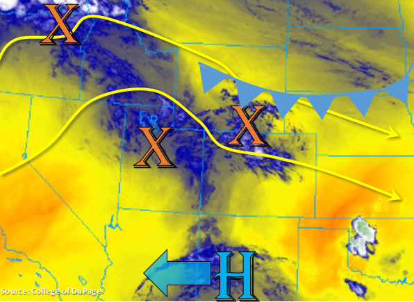
To the east, a cold front will start to drop south this morning associated with the passing trough. Moisture is forecast to increase to some extent behind this feature, which will allow for some high-based, weak thunderstorms over the Front Range this afternoon and evening driven by the diurnal flow. Again, gusts from storms and cloud-to-ground lightning will be the main threats rather than accumulating rainfall, so enhanced fire weather is forecast for the eastern mountains as well. Not looking like there will be a lot of storms associated with this feature over the eastern plains, but a couple weak thunderstorms may fire along this boundary over the far Southeast Plains this afternoon. Flooding is not forecast.
Today’s Flood Threat Map
For more information on today’s flood threat, see the map below. For Zone-Specific forecasts, scroll below the map.
Zone-Specific Forecasts:
Northwest Slope, Grand Valley, Southwest Slope, Northern Mountains, Central Mountains, San Juan Mountains, Front Range, Southeast Mountains, San Luis Valley:
Hot temperatures and low relative humidity continues with an increase in chances for high-based storms this afternoon. The threat of dry thunderstorms returns the Red Flag Warning to the Northwest Slope with enhanced fire weather forecast for the higher terrains. Best chance for measurable rainfall will be over the San Juan Mountains/Dolores County and along the Continental Divide. Highest totals could reach 0.15 inches, but gusty winds and virga are more the more likely scenario with storms this afternoon and evening. High temperatures are forecast to reach the mid 90°Fs over the lower valleys.
Primetime: Noon to 10PM
Urban Corridor, Palmer Ridge, Raton Ridge, Southeast Plains, Northeast Plains:
The Southeast Plains will come close to the 100°F mark, so the cool down earlier this week will feel like a distance memory. A couple storms could fire along the cold front this afternoon over the Southeast Plains. Small hail, gusty winds and light rainfall will be the main threats. Max 1-hour rain rates up to 0.25 inches will be possible. Guidance hinting at some weak post frontal upslope storms over the Raton Ridge and southern Front Range around midnight, but totals should remain under 0.1 inches.
Primetime: 2PM to 9PM