Issue Date: Wednesday, August 28th, 2019
Issue Time: 10:15AM MDT
–Flooding is NOT expected today
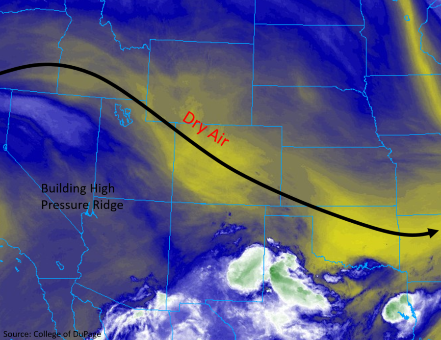
Hot, dry weather is expected statewide today as the upper level high continues to build over the desert southwest. Shown in the mid-level water vapor imagery below is the dry air mass that has been over the state throughout this week (yellow shading). Just how dry is it? PW continues to near (daily) record minimums both at Grand Junction and Denver. As a result, measurable rainfall is very unlikely statewide. An isolated thunderstorm may pop over Baca County along a dryline, but chances of this happening are low.
Surface winds are anticipated to increase, and with relative humility forecast to be in the teens to single digits, a Red Flag Warning has been issued for Moffat County and the upper elevations of the Front Range, Northern Mountains and Central Mountains through 8PM this evening. Elevated fire danger is forecast for the entire state with the low relative humidity values this afternoon.
Today’s Flood Threat Map
For more information on today’s flood threat, see the map below. For Zone-Specific forecasts, scroll below the map.

Zone-Specific Forecasts:
Northwest Slope, Northern Mountains, Front Range, Central Mountains, Grand Valley, Southwest Slope, San Juan Mountains, San Luis Valley:
A Red Flag Warning has been issued for northwest Moffat County and the high elevations of Front Range, Northern Mountains and Central Mountains. Over Moffat County, sustained southwest winds between 10 and 15 mph are forecast with gusts up to 30 mph. Over the mountains, sustained, westerly winds are forecast to be between 10 and 20 mph with most wind gusts in the 30 to 35 mph range. Please use caution with open flames as critical fire weather allows fire to spread rapidly. The heat begins to return as well with high temperatures increasing by ~5-7°F. The Grand Valley and Southwest Slope are expected to reach the mid 90°Fs once again. Expect an increase in cloud cover from west to east overnight as the next system moves into the state.
Urban Corridor, Northeast Plains, Palmer Ridge, Southeast Plains, Southeast Mountains, Raton Ridge:
High temperatures are forecast to increase significantly over the region today (greater than 10°F over the Northeast Plains). Sunny skies and southerly surface flow will be the culprit of the rapid rise in temperatures. Highs are expected to reach into the low to mid 90°Fs over the eastern plains and the 80°Fs over the higher terrain to the west. Upslope flow of residual moisture over the Raton Ridge could produce a raindrop or two, but virga is the more likely scenario. The best chance for rainfall today, which is still an outside shot, will be over Baca County. There may be a thunderstorm that pops along the dryline with lift provided from a passing shortwave. Max 1-hour rain rates up to 0.5 inches will be possible if this storm can break the cap.
Primetime: 2:30PM to 6PM