Issue Date: Friday, August 23rd, 2019
Issue Time: 10:15AM MDT
Summary:
Another round of isolated severe thunderstorms over eastern Colorado on Thursday. While moisture dropped off near the eastern mountains, due westerly flow aloft mixing out moisture to the east, enhanced lift from the approaching trough caused some cloudy afternoon skies and enhanced storm coverage. Afternoon upslope flow generated storms over the Front Range, Southeast Mountains and western Palmer Ridge around 2PM, which moved into the adjacent plains by mid-afternoon with westerly steering flows. Storms were moving fairly fast, and high-based to the west, but they were still able to drop some decent accumulations. As they moved east, their rainfall rates increased due to the higher moisture content of the atmosphere.
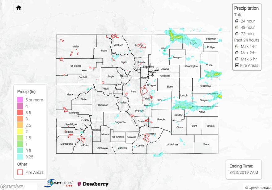
A Flash Flood Warning was issued over the Spring Creek burn area at 4:30 PM with 1-hour rainfall totals estimated at 0.33 inches from MetStorm before the bias correction. There was an observation of 0.36 inches in La Veta, but as of this morning, there was no flooding reported near the burn area. Another storm in El Paso County near Garden of the Gods produced nickel sized hail and storm totals close to 0.2 inches (USGS gage at Douglas Creek). The USGS gage, Cheyenne Creek at Evans, observed 0.67 inches, which is slightly south of the hail report. As these storms moved west, they dropped up just under 1.5 inches over southern Lincoln County with CoCoRaHS stations in the area recording between 0.67 and 0.97 inches. An outflow boundary kicked off an additional storm over southern Yuma County were radar estimated up just over 2 inches fell.
To the north over Weld County, a little better moisture held on near the CO/WY/NE border. A storm that formed over the Cheyenne Ridge merged with another storm coming off of the northern Front Range. This storm ended up dropping an estimated 2.25 inches over a small area, and a MesoWest station near Sterling picked up 0.68 inches from this same storm as it moved east. Note this storm ran into a cap over the northeast corner, so it quickly weakened east of Logan County. Thankfully, no more than 1 inch hail was reported with this storm. Right before the storm merged, a weak tornado was reported near Roggen in Weld County (between Wiggins and Hudson on I-76), which lasted for 6 minutes. NWS will be doing a follow up report to confirm this tornado sometime in the next couple of days.
Back to the west there were a couple of rounds of brief showers over the San Juan Mountains and near the Continental Divide. The approaching trough brought increased lift to the area, so there was a bit more cloud cover to help with the heat over higher terrains. Storms yesterday were once again high-based, so the rainfall remained light. MetStorm indicates most totals over the San Juan Mountains were under 0.1 inches with a couple reports near 0.15 inches. Evaporation of the storms also caused some brief, gusty winds in addition to stronger surface winds from the tightening gradient. Not surprisingly, there was a Red Flag Warning over the Northeast Corner, though it is likely critical fire weather might have been reached over small areas of the high terrains as well. Winds gusts yesterday (thunderstorm and non-thunderstorm) ranged from 45 to 55 mph with sustained winds near 15mph over the Northwest Slope.
To see estimated precipitation totals over your neighborhood on Thursday or for the last 72-hours, scroll down the State Precipitation Map below.
Click Here For Map Overview