Issue Date: Thursday, August 22nd, 2019
Issue Time: 10:15AM MDT
Summary:
Quite a bit of moisture in the atmosphere after the passage of a cold front early Wednesday morning. Post frontal upslope flow in this moisture rich environment, with slow steering winds, set the stage for pockets of heavy rainfall. Strongest storms popped up where there was the best break in cloud cover. Rainfall began first to the south over the eastern mountains, then to the north where it took a little longer to erode the cap. Several flood advisories were issued beginning at 1PM and ending at 10:15PM with one Flash Flood Warning issued for Denver at 6:40PM. Storms yesterday were nearly stationary with outflow boundaries and back building storms helping set off more storms over the same area. There were also two flood advisories issued for the Spring Creek and Junkins burn areas, but flooding was not reported. MetStorm indicates just over 0.5 inches and 0.25 inches fell, respectively, which are below known flash flooding rate criteria. A Severe Thunderstorm Warning was issued for the Front Range, Urban Corridor, Palmer Ridge and portions of the Northeast Plains at 4PM, so plenty of warning before the storms struck.
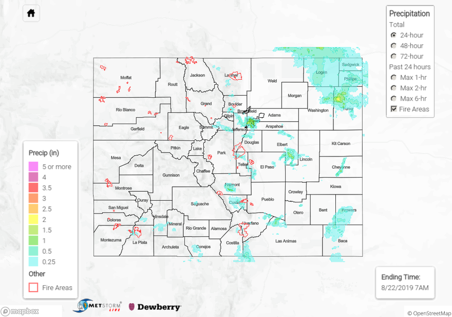
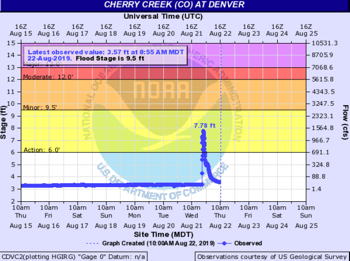
Denver had a whopper of a storm just after rush hour that lasted over an hour, caused intermittent power outages and flooding of low-lying intersections. Quite a bit of lightning with it, too along with 1 inch hail. The highest ALERT gage (I-25 and 6th Ave) indicated up to 1.9 inches of rainfall though this gage may have been slightly contaminated by hail as totals nearby were not this high. The highest area of rainfall looked to be near Wings Over the Rockies where gages had between 1.1 and 1.5 inches of rainfall over a fairly large area. The Cherry Creek gage briefly reach Action Stage (below). To take a look for yourself, click here and change options (top left) to 24-hour rainfall: http://alert5.udfcd.org/LDAD/gmapV3.html
Further south, over Fremont County, there was also some heavy rain where MetStorm indicates up to 1.25 inches fell. The cap never did break over the Southeast Plains, so the anticipated heavy rainfall threat never materialized over this region. Although there were totals up to 1.25 inches over Las Animas County, which was in the Low threat area. Storms also moved in over Yuma County from the panhandle, which dropped between 2 and 2.5 inches in its core. There were no official LSRs (Local Storm Reports) this morning, although flooding was confirmed by several Twitter users.
To see estimated precipitation totals over your neighborhood on Wednesday, scroll down the State Precipitation Map below.
Click Here For Map Overview