Issue Date: Saturday, August 17th, 2019
Issue Time: 8:25AM MDT
— Flooding is NOT expected today
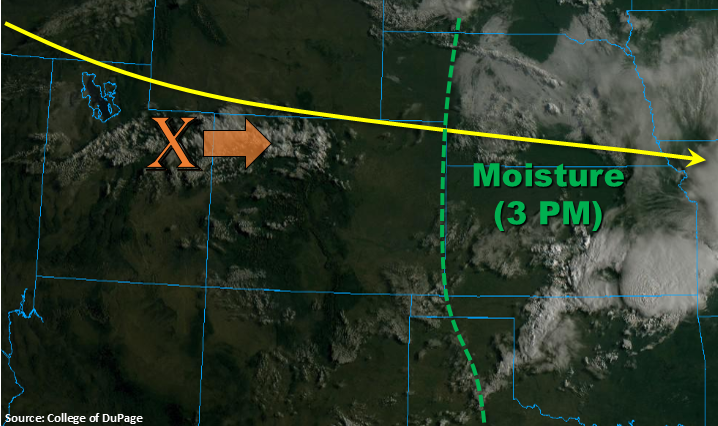
The ridge pattern has completely broken down and flow has become zonal statewide as the base of the trough passes over the state. The strong westerly flow will mix out all the of moisture from west to east beginning this morning, and the best moisture this afternoon will be east of the green dashed line below. A shortwave, marked with the orange “X”, is forecast to move east with the zonal flow throughout the day. This will help spark widespread afternoon storms over the Front Range and then adjacent plains this afternoon as the westerly flow pushes them off the higher terrain. Since the best moisture will be east, storms are expected to be high-based and produce little rainfall with brief, gusty winds. Best accumulations will be over the border counties where dew points will be in the 40°Fs. Flooding is not forecast.
Today’s Flood Threat Map
For more information on today’s flood threat, see the map below. For Zone-Specific forecasts, scroll below the map.
Zone-Specific Forecasts:
Front Range, Southeast Mountains, Urban Corridor, Palmer Ridge, Raton Ridge, Northeast Plains, Southeast Plains:
Not expecting a lot of rainfall today from storms as they will be high-based. They will provide some nice shade from the sun over the northeast quadrant of the state. Gusty winds will be possible along with some weak thunderstorms. Max 1-hour rain rates west of Washington County should remain below 0.1 inches with max 1-hour rain rates increasing to 0.6 inches over the border counties.
Primetime: 1PM to 9PM
Northwest Slope, Grand Valley, Southwest Slope, Northern Mountains, Central Mountains, San Juan Mountains, San Luis Valley:
Critical fire weather continues today with the Red Flag Warning now extending into the San Luis Valley. High surface winds are mixing to the surface due to the jet stream sitting over the northern border as the base of the trough passes. Winds are forecast to be from the southwest at 15 to 25 mph with gusts up to 45 mph possible. A few clouds will be possible over the northern border as shortwaves move through the area, but other than a couple of rain drops, rain is not forecast. Please use caution with open flames.