Issue Date: Friday, August 16th, 2019
Issue Time: 10:45AM MDT
—A LOW flood threat has been issued for the Northeast Plains
The threat of isolated, severe thunderstorms will return to the Northeast Plains once again today with multiple dynamic features in place to aid in severe thunderstorm development. Early morning fog and low level cloud cover can be seen visible satellite imagery below over the northeast quadrant of the state thanks to an outflow boundary from the MCS over Nebraska. This shows the moisture return to the area and will help contribute to instability later this afternoon. A low pressure system over the southeast corner of the state will also advect in low level moisture to the eastern plains throughout the day with southeasterly flow. The jet streak that has been perched over the northern border is forecast to move slightly east throughout the day, putting the Northeast Plains in a favorable position for extra lift.
An embedded shortwave that will pass over the CO/WY border during peak heating this afternoon, which will help break the cap and contribute to more widespread coverage of thunderstorms this afternoon. Additionally, lee troughing is expected to create a surface low and vorticity maximum over the eastern plains, which will also help aid thunderstorm development over the southern Urban Corridor and Palmer Ridge intersect. Storms are forecast to initiate along the stationary front (red dashed line below) early this afternoon. PW over the eastern plains will increase to ~1.1 inches over the far northeast corner, with surface dew points over the area remaining in the 60°Fs throughout the day. Although storm motion will be to the east around 20 mph, storms have been maximizing rainfall rates in this moisture rich environment the last few days. Additional storms may pop from outflow boundaries, which would increase rainfall accumulations over localized areas. Thus, a Low threat has been issued for field ponding, road flash flooding and local stream/creek flash flooding. The wind profile in this morning’s Denver sounding indicate severe storms that form over the Low threat area will again produce damaging winds and very large hail. Hail size may again reach sizes close to tennis balls.
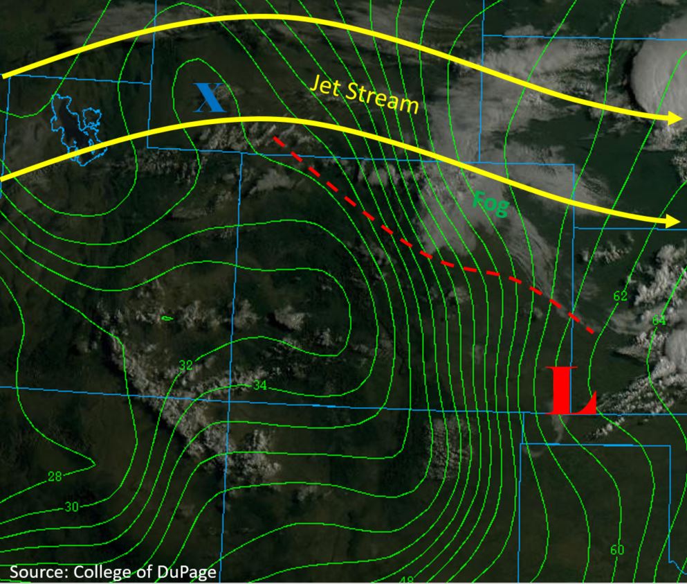
Mid-level moisture advection can be seen by the cloud cover over Utah this morning. Westerly flow of this moisture over the western border into the higher elevations will provide some cloud coverage, but fast steering flows and insufficient moisture at other layers of the atmosphere should keep accumulations to under 0.1 inches again. The best chance for this measurable rain is over the eastern San Juan Mountains. As forecast in the FTO, dew points over the west measured in the 30°F’s this morning (green contours below), but are forecast to decrease by 10°F-20°F throughout the morning. Thus, a Red Flag Warning is in place with high winds mixing down to the surface from the jet over the northern border. Please use caution with open flames.
Today’s Flood Threat Map
For more information on today’s flood threat, see the map below. For Zone-Specific forecasts, scroll below the map.

Zone-Specific Forecasts:
Front Range, Urban Corridor, Northeast Plains, Palmer Ridge, Southeast Plains, Southeast Mountains, Raton Ridge:
Storms are forecast to begin early this afternoon over the high terrains favoring the Palmer Ridge and Cheyenne Ridge for development. Brief isolated showers are also possible over the Front Range and Southeast Mountains this afternoon, but only trace amounts of rain are expected. The primary threat over the high country and surrounding plains will be brief, gusty winds from storms in the vicinity.
Max 1-hour rain rates up to 0.5 inches will be possible as storms begin traveling east of the I-25 corridor. As they move east at 20 mph, the environment will promote severe thunderstorm development (Northeast Plains). Max 1-hour rainfall rates up to 1.75 inches will be possible within the storm cores due to dew points in the 60°Fs. The primary threats for today include heavy rainfall, damaging winds (> 60 mph) and large hail. Heavy rainfall from Tuesday and Wednesday over southern Yuma, Kit Carson and Cheyenne Counties may cause a little more runoff, but rain rates further south should be closer to 1.15 inches and storms are forecast to be fairly isolated, so flooding issues should be avoided.
Primetime: 2PM to 11PM
San Luis Valley, San Juan Mountains, Southwest Slope, Grand Valley, Northwest Slope, Central Mountains, Northern Mountains:
A slight increase in mid-level moisture from the southwest will provide a chance for isolated, weak showers again this afternoon over the eastern San Juan Mountains. Max 1-hour rain rates will remain below 0.1 inches again, so flooding is not expected. Storms may produce some gusty outflow winds. Upper level steering flows increase from 20 mph over the San Juan Mountains to 45 mph over the Northern Mountains. These fast steering flows will increase the fire threat, so a Red Flag Warning has been issued. Please follow NWS Pueblo for the latest on this threat.
Primetime: 1PM to 8PM