Issue Date: Friday, August 2nd, 2019
Issue Time: 10:00AM MDT
Summary:
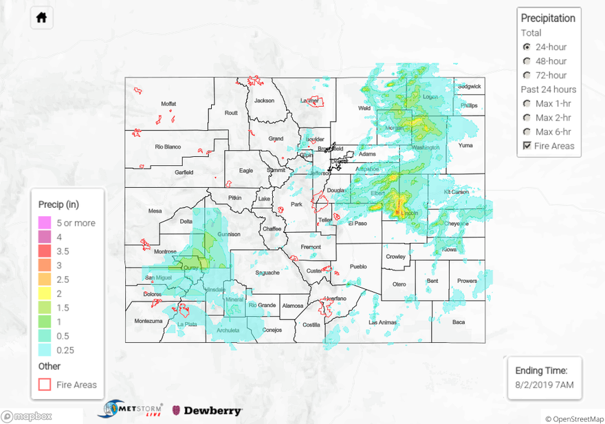
Heavy rainfall day across the state during the peak of the latest monsoon surge. Only a few isolated areas didn’t receive any rainfall. We’ll start over eastern Colorado. Lee troughing allowed for some severe weather over the eastern plains as well thanks to directional shear. Storms began to form over the mountains around 1PM with additional storms forming over the Northeast Plains a couple hours later. A Severe Thunderstorm Watch was issued around 3PM for the Northeast Plains, Palmer Ridge and eastern portion of the Urban Corridor. Storms eventually moved east and formed into a cluster, which allowed for some widespread rain last night. Overall, storms yesterday initially (before they clustered into a MCS) produced 60 mph gusts with hail up to 1.75 inches reported over Logan County. Smaller hail was realized over Cheyenne County (0.7 inches) as instability/dynamics decreased later into the night. There were several reports of heavy rain over Lincoln County with the highest report being 3 inches in 1.5 hours. Another spotter recorded 1.94 inches in 45 minutes over this area. MetStorm indicates up to 3.5 inches fell in this core, although this value seems a little inflated given the reports in the area. Up to 2.5 inches fell in northern Washington County according to radar estimations. A CoCoRaHS station in Akron recorded 1.63 inches for the event.
A hefty amount of rain also fell over Southwest Colorado. QPE (especially Max 1-6 hours) by MetStorm may be a little wonky spatially over the high terrains due to the GJT radar being down (routine maintenance through Aug 3rd), but still some great observations over the area. Over Southern La Plata County and Conejos County, there were two reports of 0.83 inches and 0.79 inches, respectively. An Areal Flood Advisory was issued for the 416 burn area at 6PM. They do have the PX1000 radar running again, so that was nice to have to monitor the situation. Flooding was not reported as of this morning, although gages near the scar recorded between 0.33 and 0.5 inches. The heaviest rainfall was over Ouray and southwestern Gunnison County. MetStorm estimates up to 1.7 inches fell for the 24-hour period. Two CoCoRaHS sites near Ridgeway, CO recorded 1.48 and 1.05 inches. A SNOTEL site near Lake City, CO had 0.8 inches for the day. Thankfully, higher rainfall amounts were just to the east and south of the Lake Christine burn area. Despite the heavy rainfall yesterday, there were no reports of flooding as of this morning.
To see estimated precipitation totals over your neighborhood on Thursday, scroll down the State Precipitation Map below.
Click Here For Map Overview