Issue Date: Friday, August 2nd, 2019
Issue Time: 9:00AM MDT
— A MODERATE flood threat has been issued for the Spring Creek, Junkins and Hayden Pass burn areas
— A LOW flood threat has been issued for the Raton Ridge, Southeast Mountains and portions of the Urban Corridor, Front Range and Central Mountains
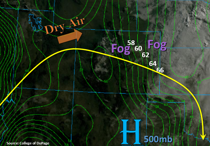
The weak cold front from yesterday has moved completely through the Southeast Plains leaving behind cooler morning temperatures and some fog. Dew points over the eastern plains are well into the 60°Fs, so not surprised by the widespread nature of the fog. It should continue to burn off as the sun heats up the surface. The subtropical high is currently over New Mexico. It is forecast to start to move to the west today, which will pull in a drier air mass into western Colorado. PW has already dropped to by about 0.2 inches in this morning’s sounding. This should limit storms to the higher terrains with scattered, weak thunderstorms and light showers possible with the residual moisture. Storms will be high-based, so not expecting much accumulation.
With steering flows having a more of a northerly component today and most of the adjacent plains capped, storms over eastern Colorado are expected to be confined to the mountains. There is a high likelihood for some spillover thunderstorms onto the Raton Ridge as well. No shortwaves or boundaries are spotted in the water vapor imagery, so the diurnally driven storms should only be weak thunderstorms with small hail and some brief, gusty winds also possible. Behind the front, low level moisture should be high (as seen with the dew points below), so heavy rainfall is anticipated over the Southern Front Range and Southeast Mountains. Trailing storms may produce just over an inch of rain in a 1.5-2 hour period or a quick 0.5 inches in 30 minutes, so a Low flood threat has been issued. With high moisture and trialing storms, the recent burn areas in the Southeast Mountains have an elevated threat. So a Moderate flood threat has been issued for these areas.
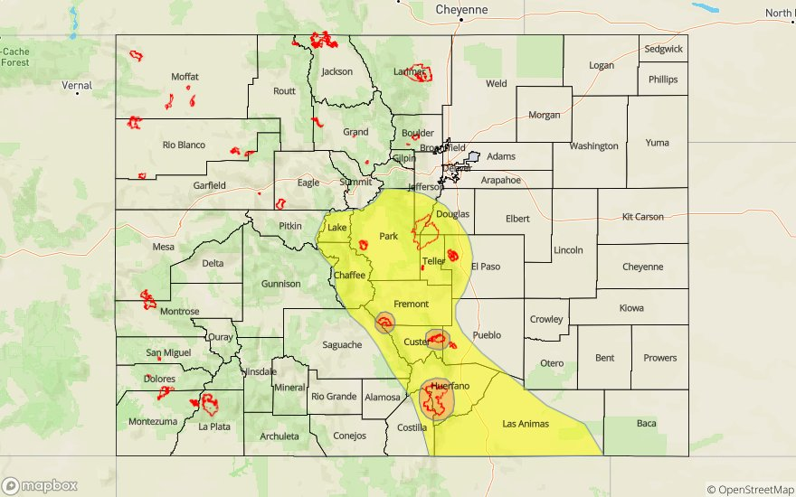
Today’s Flood Threat Map
For more information on today’s flood threat, see the map below. For Zone-Specific forecasts, scroll below the map.

Zone-Specific Forecasts:
Front Range, Southeast Mountains, Urban Corridor, Palmer Ridge, Raton Ridge, Northeast Plains, Southeast Plains:
Most of the eastern plains and adjacent plains should remain rain free this afternoon. However, there is a 50/50 chance for some thunderstorms along the southern border from the Southeast Mountains to the KS/OK border. As far as rainfall, trailing storms make the threat today more of a 1.5-2 hour threat. Isolated storm totals up to 1.25 inches may be possible (more likely values will be closer to 1 inch) over the Southeast Mountains and western Raton Ridge. With burn area flooding thresholds likely being met this afternoon by storms in the area, a Moderate flood threat has been issued. One inch totals over the Park/Teller County are also possible by tomorrow morning. Note the flood threat is slightly less over this area due to more gradual rain rates. Flood threats today include mud flows, debris slides, local stream/creek flash flooding and flooding of low-lying intersections. A couple storms may linger through the night over the Southeast Mountains, but the threat should a couple hours after the sun sets.
Primetime: 1:30PM to 11PM
Northwest Slope, Grand Valley, Southwest Slope, Northern Mountains, Central Mountains, San Juan Mountains, San Luis Valley:
Best chance for thunderstorms today will be over the eastern portion of the Central and San Juan Mountains. Higher moisture to the south should increase max 1-hour rain rates up to 0.75 inches. Storm totals over the 416 burn area should remain below flood threat criteria, though this should be monitored closely if multiple storms track over the scar. Elsewhere, storms are forecast be more isolated over the higher elevations. With drier air moving in from the west, max 1-hour rain rates drop off to 0.2 inches over the north. With the current environment, a couple of storms may linger over the highest terrains of the eastern Central and San Juan through the night, but most storms are expected to dissipate a couple hours after sundown.
Primetime: 12:30PM to 11PM