Issue Date: Thursday, August 1, 2019
Issue Time: 10:20AM MDT
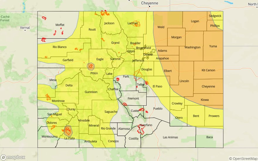
-A MODERATE flood threat has been issued for portions of the Northeast Plains, Palmer Ridge, and Southeast Plains. A MODERATE flood threat has also been issued for the 416 and Lake Christine burn areas
-A LOW flood threat has been issued for portions of the Southwest Slope, San Juan Mountains, Grand Valley, Central Mountains, Northwest Slope, Northern Mountains, Front Range and Urban Corridor
The atmosphere is saturated across the state today as monsoonal levels of moisture have come in from the southwest. The high pressure ridge has moved slightly to the east, putting Colorado right on the path of high moisture advection. PW this morning was measured in the 95th percentile at Grand Junction, with 1.23 inches. Model derived PW over Denver is 1.12 inches. Moisture is also high at the surface, with dewpoints (green contours below) in the 60°Fs over the far eastern plains and 50°Fs over the western slope. Cloud cover this morning will prevent surface moisture from mixing out, keeping instability moderate to high over the Northeast Plains. Continual flow of moist air over the mountains will produce thunderstorms over the high country throughout the day and into the night.
A shortwave and vorticity maximum (X below) is forecast to move across the northern border throughout the day, providing lift for severe thunderstorms this afternoon and into the night. At the surface there is currently a low pressure system (“L” below) over the Southeast Plains. Upslope flow to the north of the low will provide continuous moisture advection to the northeast quadrant of the state, while downsloping flow over the southeast quadrant should prevent severe storms over the area. Slow upper level steering flows of 12-17 mph (east) and 17-22 mph (west) will create a threat that is 2-3 hours in nature. A low level jet is forecast to form over the eastern plains by sundown tonight, which will provide dynamic forcing for severe storms until 2AM. The National Weather Service has issued a Flash Flood Watch for: northeast Weld County, Morgan County, central and east Adams and Arapahoe Counties, north and northeast Elbert County, north Lincoln County, Logan County and Washington County.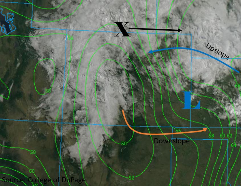
Today’s Flood Threat Map
For more information on today’s flood threat, see the map below. For Zone-Specific forecasts, scroll below the map.

Zone-Specific Forecasts:
Front Range, Urban Corridor, Northeast Plains, Palmer Ridge, Southeast Plains, Southeast Mountains, Raton Ridge
Passage of the shortwave over the northern border will produce severe thunderstorms over the northern half of the forecast region this afternoon and into the early morning. Storms will begin over the high country around noon and move over the adjacent plains by 2PM. A quasi-linear convective system (QLCS) or line of storms capable of producing strong winds is forecast to form over the Northeast Plains mid-afternoon, producing widespread rain over the area. Slow steering winds will create a 2-3 hour threat over most areas, but isolated 1-hour heavy rain is still possible. Over the northern half of the Front Range and Urban Corridor, max 2-3 hour rainfall rates up to 1.5 inches and isolated max 1-hour rain rate up to 0.75 inches are possible. Hail up to 0.5 inch diameter is forecast for these areas. Over the Northeast Plains max 2-3 hour rainfall rates of 2.5 inches and max 1-hour rainfall rates of 1.75 to 2 inches are forecast within the Moderate Flood Threat region. Hail up to 1.75 inches diameter is forecast over the area as well. Threats include flooding of small streams and rivers, flooding of roadways and low laying intersections, and field ponding.
Downsloping flow over the southern half of the Front Range and Urban Corridor, as well as the Southeast Mountains will keep rainfall rates low. Max 1-hour rainfall rates of 0.5 inches are forecast, with the higher rates more likely to the north. Areas of the Southeast Plains outside of the threat area are forecast to have max 1-hour rainfall rates of 0.3 inches, with isolated pockets up to 0.5 inches.
Primetime: 12PM to 2AM
San Luis Valley, San Juan Mountains, Southwest Slope, Grand Valley, Northwest Slope, Central Mountains, Northern Mountains:
A Moderate Flood Threat is Issued for the 416 and Lake Christine burn areas, with max 2-3 hour rainfall rates up to 1.25 and 0.75 inches respectively. Multiple storms passing over the burn areas may cause flash flooding, with threats of mud slides, debris flows and flooding of small rivers and streams. Over the high country, max 1 hour rainfall rates are forecast to be between 0.5 and 0.75 inches, with isolated storms capable of producing 1 inch. Multiple rounds of storms over the area will provide max 2-3 hour rainfall rates up to 1.5 inches. Threats include flash flooding and flooding of roadways and low laying intersections.
Primetime: 12PM to 12AM