Issue Date: Wednesday, July 31, 2019
Issue Time: 10:35AM MDT
— Flooding is NOT expected today
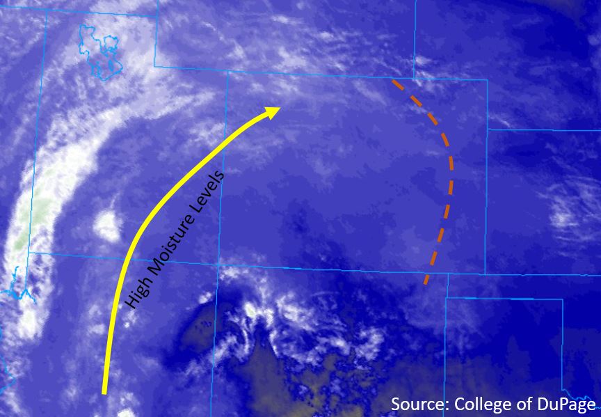
The subtropical high pressure that has been controlling our weather this past week will continue to build and move it’s way east throughout the day today. The mid-level water vapor imagery below shows high levels of moisture to the west of Colorado, which will move it’s way slowly over the area the next few days. This morning’s sounding over Grand Junction shows an increase in moisture from yesterday, measuring 0.98 inches of PW. Dewpoints over the western slope are also high this morning, measuring in the 40°Fs and 50°Fs over the lower terrain. Midlevel winds will increase throughout the day, with a weak low level jet developing overnight over the northwest corner of the state. Persistent thunderstorms over the area provide the highest chances for isolated moderate rainfall over 2-3 hours. Storms are forecast to the west of the Continental Divide throughout the afternoon and into the early evening, with storms over the northwest quadrant extending into the early morning.
To the west of the Continental Divide the setup will be similar to yesterday, but moisture levels will increase throughout the day. PW was measured at 0.69 inches over Denver this morning, but is forecast to increase up to 1.7 inches over the Northeast Plains. Low pressure over the eastern plains will aid downslope flow to create a dryline (orange line below) over the eastern plains this morning. The low is forecast to remain and deepen, which will pull surface moisture back to the west throughout the forecast period. Upslope flow over the foothills and the dryline will provide forcing for thunderstorms this afternoon. Storms are forecast to begin over the Raton Ridge and Southeast Plains by 12PM, with storms over the Palmer Ridge and Northeast plains this afternoon and into the night.
Today’s Flood Threat Map
For more information on today’s flood threat, see the map below. For Zone-Specific forecasts, scroll below the map.

Zone-Specific Forecasts:
San Luis Valley, San Juan Mountains, Southwest Slope, Grand Valley, Northwest Slope, Central Mountains, Northern Mountains:
Isolated max 3-hour rainfall rates up to 0.75 inches will be possible over the northern regions, with max 24-hour totals up to 1.5 inches. Expect the highest daily totals over the Northwest Slope and Northern Mountains, with persistent storms throughout the duration of the forecast period. Continual moisture advection and steering winds between 10 and 15 mph will bring multiple rounds of storms over the area. Rain will favor the high terrain over the Southwest Slope and San Juan Mountains, with isolated max 3-hour rainfall rates up to 0.5 inches. Storms will begin by noon over the southern regions, extending through the central and northern regions by 2PM. Rainfall is forecast over all elevations over the central and northern regions due to high levels of surface moisture. The San Luis Valley is forecast to receive little to no precipitation. Wind gusts up to 50 mph are expected over the lower elevations once again today.
Primetime: 12PM to 5AM
Front Range, Urban Corridor, Northeast Plains, Palmer Ridge, Southeast Plains, Southeast Mountains, Raton Ridge
Storms today are most likely along the Continental Divide and areas over and near the Cheyenne Ridge, Palmer Ridge and Raton Ridge. Most storms are forecast to remain capped over the eastern plains, but chances for isolated severe weather are still possible. Max 1-hour rainfall rates of 1.25 inches are possible, although unlikely, over the Northeast Plains, southern Urban Corridor and Palmer Ridge. Over the high terrain, max 1-hour rainfall rates up to 0.3 inches are possible. Storms are forecast to begin over the Raton Ridge and Southeast Mountains by noon, with storms over the Front Range by 2PM. Late afternoon thunderstorms may form off of the Palmer Ridge and move over the Northeast Plains early tonight. Flooding is not forecast over the area.
Primetime: 12PM to 2AM