Issue Date: Tuesday, July 30th, 2019
Issue Time: 10:00AM MDT
Summary:
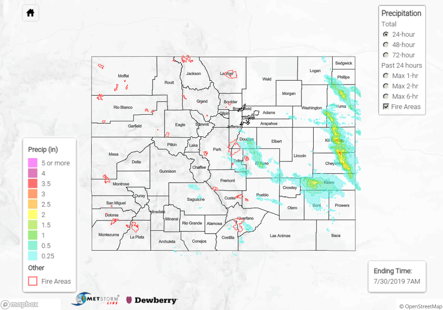
Wild weather day with heavy rainfall over the Palmer Ridge and eastern plains. A couple models yesterday morning were showing some strong CAPE over these areas, but the storms really overproduced when compared to the ensemble data. It truly was a worst case scenario. Dew points yesterday afternoon were in the 50°Fs to the west and 60°Fs near the CO/NE/KS border, which helped set the stage for heavy rainfall. Storms began to fire over the Northeast Plains along the dry line just after 2:30PM and had no trouble breaking the cap. The severe thunderstorms slowly dipped south throughout the evening and the slow steering winds (most totals are over a 2-hour period) in a moisture rich environment caused some very high accumulations. On top of that, golf ball sized hail and 80 mph winds from the outflow boundary caused two semis to be flipped over in Kit Carson County. There were two Flash Flood Warnings at 6PM for Kit Carson and Cheyenne Counties with flash flooding reports to go along with those. Highway 24 was washed out in Kit Carson near County Road 33 and 34 with water a few inches deep reported over multiple roadways in the area. 4 inches of rain were reported 12 miles north of Stratton with another report of 5.5 inches near were Highway 24 was washed out.
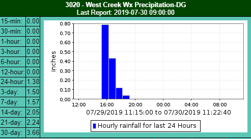
Back to the west, another couple of storms formed along the Palmer Ridge/Front Range intersect over the same period along the same boundary. They eventually created one storm that produced several inches of hail covering the roadways around 4:30PM in the Colorado Springs area (it looked like snow!). This same storm produced two funnel clouds and had a Tornado Warning from ~4:50 to 5:30PM MDT. There was a heavy rainfall report of 1.25 inches 3 miles west of Falcon, CO. The Upper Sand Creek USGS station near Lochwinnoch Lane recorded 0.99 inches during the storm. The ALERT gage near West Creek recorded 1.4 inches for the day with 1.16 inches falling in 1-hour. MetStorm (after the bias correction) estimates up to 1.42 inches in the core, but 1-hour rain rates (not bias corrected) indicates up to 1.9 inches fell. Two CoCoRaHS in the Monument area recorded 1.61 inches, so thinking the unbias corrected values are closer to reality. The storm eventually moved southeast into the Southeast Plains and merged with the storms to the north. They exited the state into the KS/OK Panhandle around 1AM MDT, but not before dropping 2.25 inches in western Kiowa County.
To see estimated precipitation totals over your neighborhood on Monday, scroll down the State Precipitation Map below.
Click Here For Map Overview