Issue Date: Sunday, July 28, 2019
Issue Time: 9:40AM MDT
–Flooding is NOT expected today
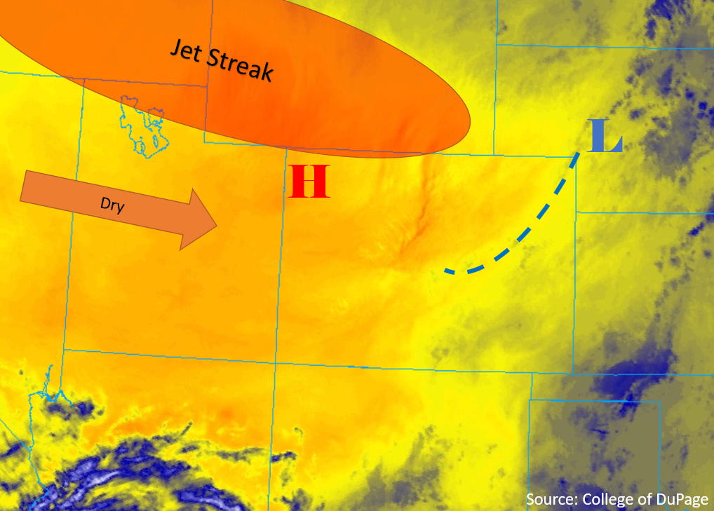
Mostly sunny skies and seasonal temperatures are expected throughout the state today as dry air makes its way in from the west. High pressure remains centered over the desert southwest, with zonal flow over much of the western United States. The right exit region of the jet streak over northern Colorado should prevent severe weather today. Atmospheric moisture is moderate to high this morning, with Denver and Grand Junction measuring between 0.9 and 1.0 inches of PW this morning. However, most of the moisture is surface based and confined to the low-levels after yesterday’s widespread rain. At the surface, high pressure (H below) has set in over the northwest quadrant of the state, and the low that provided rain yesterday has moved into western Nebraska. A cold front (blue line below) is forecast to move south over the eastern plains throughout the morning, which should cap most of the area to severe thunderstorms later in the day. Sunny skies and north-northwest surface flow will mix out most of the moisture statewide this morning and into the early afternoon. Dewpoints are forecast to drop 15-20 degrees statewide throughout the day. Chances for weak afternoon storms will be confined to the high country, with the highest chances for precipitation over the Continental Divide and San Juan Mountains.
Today’s Flood Threat Map
For more information on today’s flood threat, see the map below. For Zone-Specific forecasts, scroll below the map.

Zone-Specific Forecasts
Front Range, Urban Corridor, Southeast Mountains, Raton Ridge, Northeast Plains, Palmer Ridge, Southeast Plains:
Downslope flow throughout the morning and early afternoon should provide mostly sunny skies over the area today. There is a moderate chance for afternoon thunderstorms over the high country throughout the afternoon, with the greatest chance over the Southeast Mountains. High storm bases will limit max 1-hour rainfall rates to 0.3 inches over the mountains. The passage of the cold front over the eastern plains this morning should cap most storms over the area. Storms may generate off of the Raton Ridge and Chayenne Ridge mid-afternoon, providing chances for storms over the corners of the Southeast and Northeast Plains. Max 1-hour rainfall rates of 0.6 inches are forecast over the area.
Primetime: 12PM to 8PM
Northwest Slope, Northern Mountains, Grand Valley, Central Mountains, Southwest Slope, San Juan Mountains, San Luis Valley:
Chances for storms today will be confined to the high country, with higher chances favoring the San Juan and Central Mountains. Dry air advection from the northwest will confine rainfall to the highest elevations of the forecast region. Max 1-hour rainfall rates of 0.25 inches are forecast over the Central and San Juan Mountains. Dewpoints are forecast to drop into the teens and single digits over the northwest quadrant of the forecast area.
Primetime: 12PM to 6PM