Issue Date: 7/27/2019
Issue Time: 9:30 AM
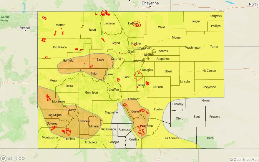
A MODERATE FLOOD THREAT HAS BEEN ISSUED FOR PORTIONS OF THE SAN JUAN MOUNTAINS, SOUTHWEST SLOPE, SOUTHEAST MOUNTAINS, CENTRAL MOUNTAINS, GRAND VALLEY, NORTHERN MOUNTAINS, AND NORTHWEST SLOPE.
A LOW FLOOD THREAT HAS BEEN ISSUED FOR PORTIONS OF THE REGIONS OUTLINED ABOVE, PLUS THE RATON RIDGE, SOUTHEAST PLAINS, PALMER RIDGE, NORTHEAST PLAINS, URBAN CORRIDOR, AND FRONT RANGE.
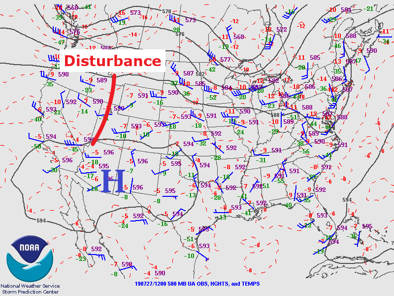
Another active weather day is in store for Colorado, with scattered-to-widespread showers and thunderstorms expected across much of the state. The high pressure that has been centered over the desert SW for the last couple of days remains in place, streaming elevated moisture into Colorado from the west. This moisture, combined with a mid-level disturbance expected to traverse the state today, has led to a spatially large flood threat for this forecast period. The main concerns will be mountain burn scars and other steep terrain areas, and these are the considerations behind the three separate moderate flood threat areas.
Spring Creek, Hayden Pass, and Junkins burn scars: Scattered thunderstorms expected, with maximum rain rates of 0.5-1.0 inches/hour possible under strong thunderstorms. Relatively quick storm motions from west-to-east will reduce the risk of flash flooding somewhat, but a moderate flood threat is warranted.
416, Bull Draw, and Lake Christine burn scars: Scattered-to-widespread thunderstorms are expected over the higher terrain today, and precipitable water values are running in the 90th percentile for the date. This ample moisture means efficient rainfall; maximum rain rates of 0.7-1.1 inches/hour possible. Quicker storm motions than the past couple of days from west-to-east will reduce the risk of flash flooding somewhat, but a moderate flood threat is warranted.
East of the Continental Divide, scattered thunderstorms are expected, beginning over the easternmost mountains between 11 AM and Noon, then spreading eastward over the plains as the disturbance passes through. Storm motions will mitigate the risk of flash flooding somewhat, but urban areas and other poorly drained locations will need to be watched as periods of heavy rainfall are expected under thunderstorms.
For more details on timing and rain rates, please see the zone-specific forecasts below.
Today’s Flood Threat Map
For more information on today’s flood threat, see the map below (hover over threat areas for more details). For Zone-Specific forecasts, jump below the map.

Zone-Specific Forecasts
Front Range, Southeast Mountains, Urban Corridor, Northeast Plains, Southeast Plains, Palmer Ridge, and Raton Ridge:
Scattered thunderstorms expected, beginning over the higher terrain by 11 AM – Noon, then spreading eastward with time. Southeast Mountains burn scars are the main concern for flash flooding issues today, but urban areas and other poorly drained locations will also be a concern as thunderstorms will be capable of heavy rainfall in short periods of time. Maximum rain rates will be 0.5-1.25 inches/hour over the Front Range and Southeast Mountains, 1.25-1.75 inches/hour over the Urban Corridor and Raton Ridge, and 2.0-2.5 inches/hour over the Northeast Plains, Southeast Plains, and Palmer Ridge.
Timing: 11 AM – Midnight for the Front Range and Southeast Mountains, 1 PM – 11 PM for the Urban Corridor and Raton Ridge, and 2 PM – Midnight for the Northeast Plains, Southeast Plains, and Palmer Ridge
Northern Mountains, Northwest Slope, Grand Valley, Central Mountains, San Luis Valley, San Juan Mountains, and Southwest Slope:
Scattered-to-widespread thunderstorms are expected today/tonight, beginning around 11 AM and ending from west-to-east from 8 PM – Midnight. Precipitable water values in the 90th percentile means that storms will be efficient rainfall producers, so locally heavy rainfall is a concern, especially with previous’ days rainfall saturating the soils a bit. Burn scars and steep terrain are the main concerns for flash flooding issues (including debris flows). Maximum rain rates are 0.7-1.1 inches/hour, perhaps up to 1.25 inches/hour over the San Juan Mountains. West-to-east storm motions will mitigate the flood threat somewhat, but an expansive low-to-moderate flood threat is warranted.