Issue Date: Thursday, July 22nd, 2021
Issue Time: 9:45AM MDT
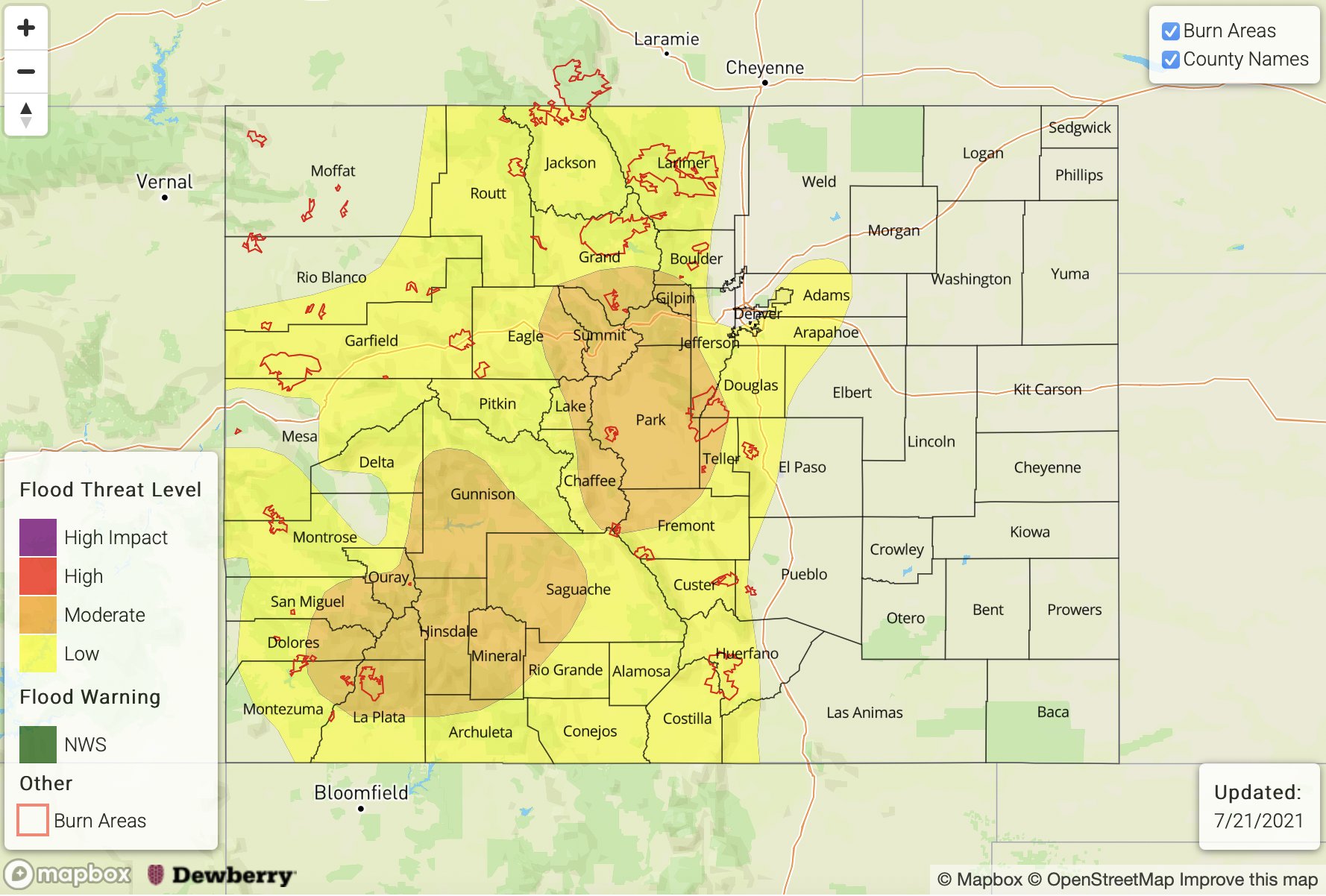
— A MODERATE flood threat has been issued for the San Juan Mountains, Northern Mountains, Central Mountains, Southeast Mountains and Front Range
— A LOW flood threat has been issued for the San Luis Valley and portions of the Northwest Slope, Grand Valley, Southwest Slope, Palmer Ridge and Raton Ridge
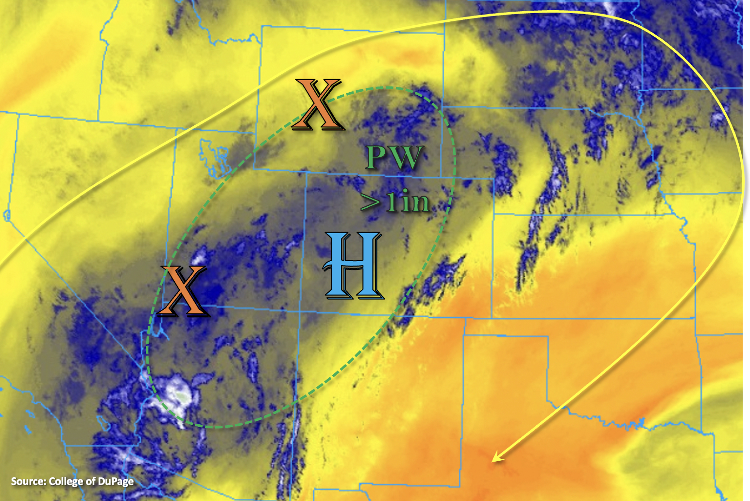
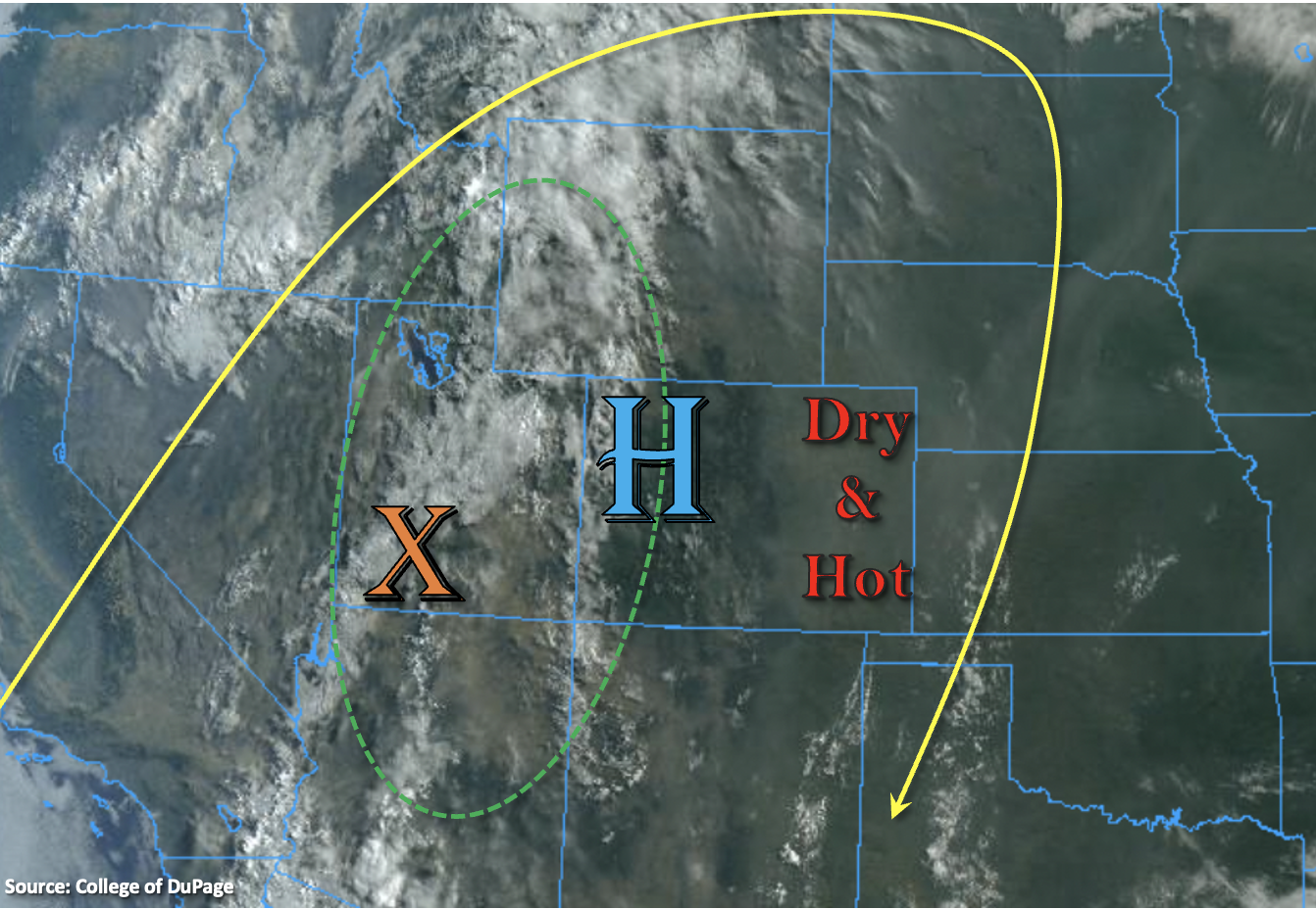
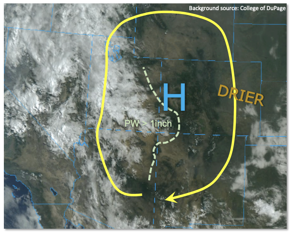
There has been little change in the atmosphere overhead over the past 24 hours, with a significantly above normal amount of monsoonal moisture continuing to rotate around the Four Corners. As shown in the visible satellite image, below, dissipating overnight showers and storms have left pockets of cloud cover mainly over the higher terrain, but this should continue to dissipate quickly with the July sunshine. PW at Grand Junction this morning measured at a whopping 1.18 inches, which is within 10% of its daily record for this time of year. Denver PW was also high at 1.07 inches. With this plentiful amount of moisture and strong heating expected in the morning hours, numerous to widespread showers and thunderstorms are expected again for basically the entire Colorado higher terrain above ~8,000 feet. Storms produced very high rainfall rates yesterday, up to 1.0inch per 20 minutes warranting a continuation of the MODERATE flood threat. Model guidance shows more potential for storms to make into the lower elevations of the Grand Valley today, so a LOW threat has been extended there. This is consistent with a nearly moist adiabatic Grand Junction sounding with a mid-level lapse rate below 7C/km. On the other hand, guidance suggests less storm activity in the foothills and plains east of the Continental Divide due to a slightly stronger atmospheric cap in place and a switch to easterly steering flow keeping storms anchored closer to the higher terrain. But otherwise, a widespread MODERATE flood threat continues for the higher terrain where max 1-hour rainfall up to 2.0 inches will cause isolated flash flooding, debris slides and mud flows. Up to 3.4 inches of 24-hour precipitation is expected through tomorrow morning. Small creek and tributary flooding will be possible in areas with multiple rounds of heavy rainfall.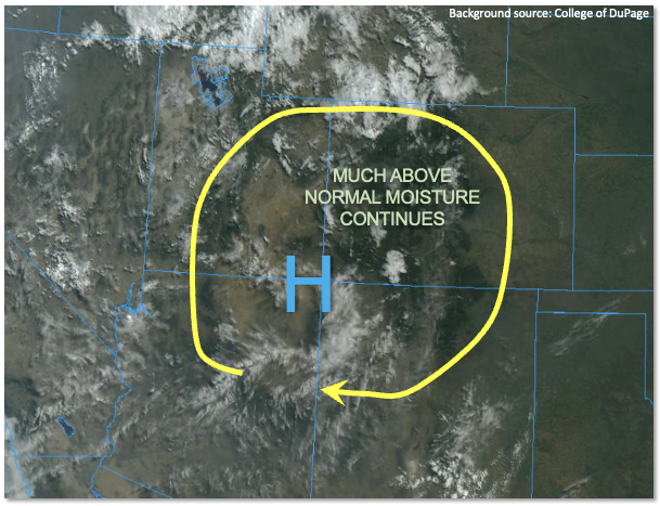
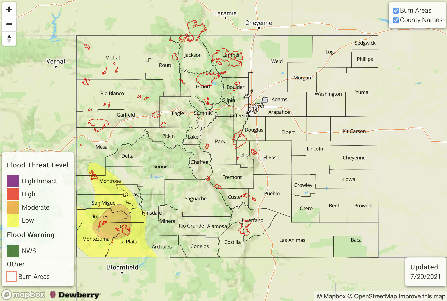
Today’s Flood Threat Map
For more information on today’s flood threat, see the map below. If there is a threat, hover over the threat areas for more details, and click on burn areas to learn more about them. For Zone-Specific forecasts, scroll below the threat map.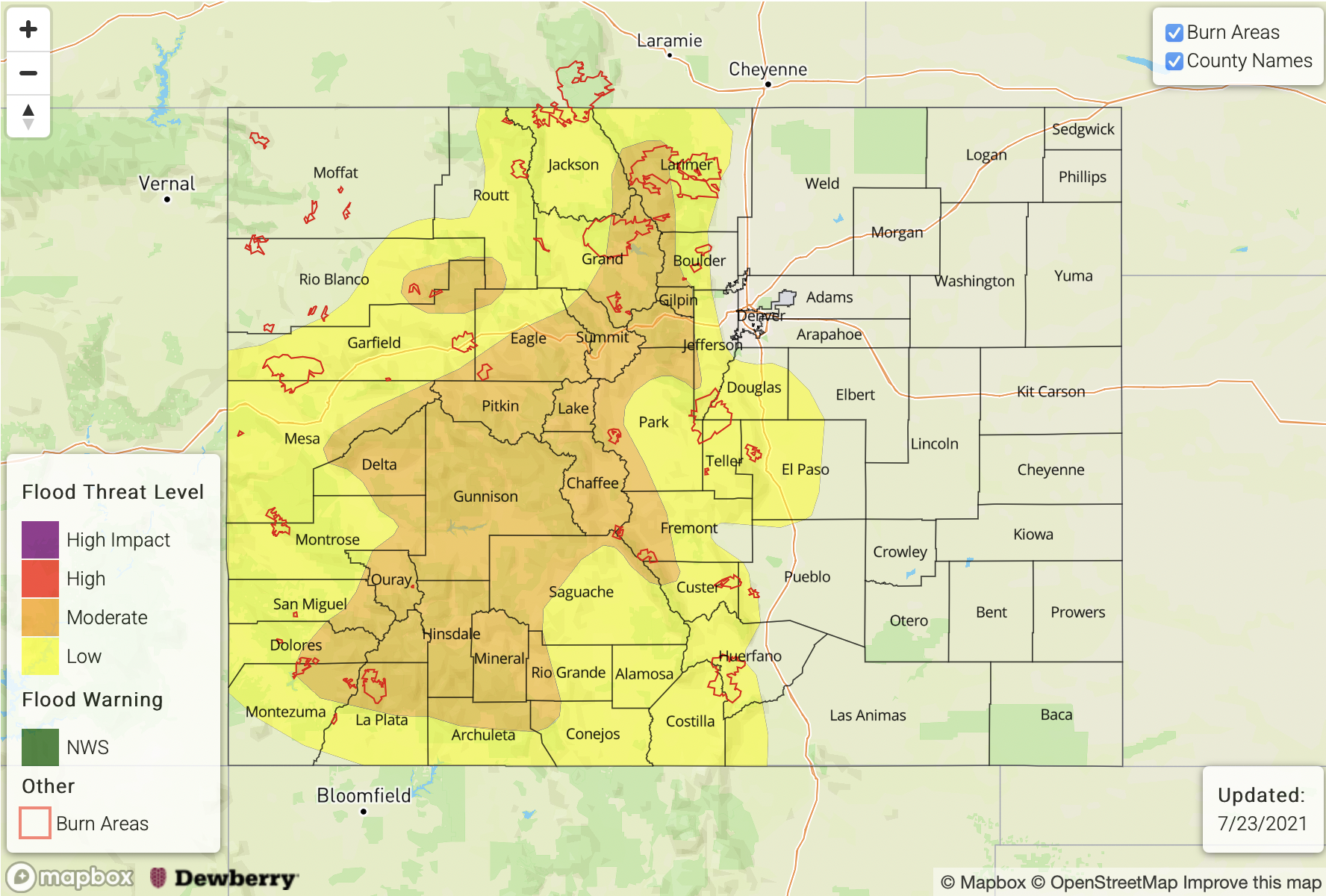
Zone-Specific Forecasts:
San Juan Mountains, Southwest Slope, Northwest Slope, Grand Valley, Northern Mountains, Central Mountains, Raton Ridge, San Luis Valley, Southeast Mountains, Front Range and Palmer Ridge:
Numerous to widespread showers and thunderstorms especially over the higher terrain above 8,000 feet. Max 1-hour rainfall up to 2.0 inches with max 24-hour rainfall (through tomorrow morning) up to 3.4 inches. Flash flooding, debris slides and mud flows will all be possible with the stronger storms and/or multiple short duration storms. Furthermore, small creek and tributary flooding will also be possible especially in regions that receive multiple rounds of heavy rainfall. This threat exists mainly over the higher terrain.
Primetime: 12PM through 11PM
Urban Corridor, Northeast Plains and Southeast Plains:
Hot with isolated to widely scattered showers and storms mainly closer to the foothills. If sufficiently strong outflow boundaries off the higher terrain make it far enough east, a strong storm could produce up to 2.0 inches per hour of rainfall especially along the I-25 corridor. However, at this time, this is unlikely and does not warrant a flood threat. Lower elevations of eastern Colorado are expected to stay hot and dry today.
Primetime: 4PM through 10PM