FTB 09-14-2015: Changes: Yes, Rain: Yes, Flood Threat: No

Issue Date: 9/14/2015
Issue Time: 10:05AM

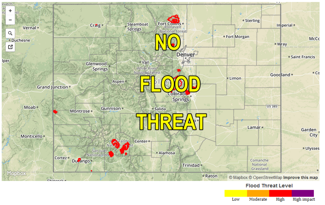
— NO Flood Threat Today

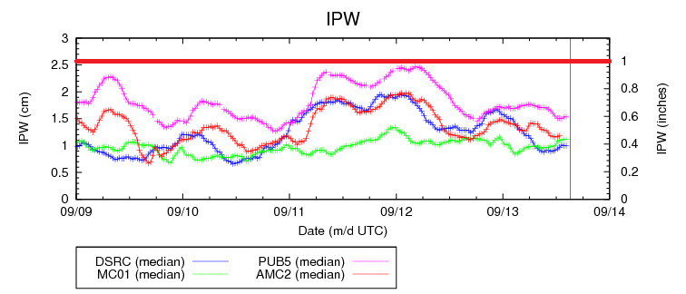
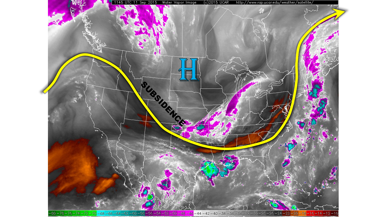
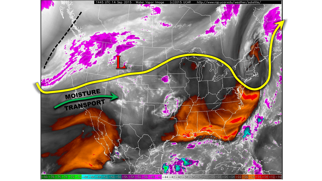
Though it certainly may not feel like it outside, today’s weather map has “Fall Is Here” written all over it (see water vapor image below). A potent large-scale trough is entering the west coast of North America. The resulting dynamics will help develop a low-pressure circulation over the northern U.S. Rockies by later this afternoon. Meanwhile, a push of subtropical moisture is also noted over southern California. In fact, the eastern fringes of this have already made it into Colorado: the precipitable water has jumped from 0.4 inches yesterday to 0.8 inches this morning. Note that this moisture transport is from the west (as opposed to south or southwest), potentially signalling that the Southwest monsoon may be waning. Collectively, these factors will support a continuous, widespread light to moderate rainfall across the Continental Divide, and locations to the west. However, the fast steering winds (increasing to 35mph and higher) and unfavorable moisture profile (low-levels remain dry) will preclude the threat of heavy rainfall. Thus, we get an optimal result: beneficial widespread rainfall, but no flood threat.

watervapor_20150914

Today’s Flood Threat Map

For more information on today’s flood threat, see the map below (hover over threat areas for more details). For Zone-Specific forecasts, jump below the map.

Flood Threat Legend

Zone Specific Forecasts

Front Range, Urban Corridor, Northeast Plains, Southeast Plains, Palmer Ridge, Raton Ridge, Southeast Mountains:

Partly to mostly sunny skies with several waves of high cloudiness streaming in throughout the day from the west. Continued warm with high temperatures 5-10F above normal. Showers and a weak thunderstorm will be possible above 8,000 feet over the Front Range, Palmer Ridge and Southeast Mountains. However, rainfall amounts will remain light, under 0.25 inches. Flooding is not expected.

Southwest Slope, San Juans, San Luis Valley, Central Mountains, Northern Mountains, Grand Valley, Northwest Slope, Southwest Slope:

Mostly cloudy skies with numerous rounds of showers and weak thunderstorms throughout the day and into the evening/overnight hours. Max 1-hour rainfall rates up to 0.6 inches will be possible. Thus, flooding is not expected. However, maximum 24-hour rainfall amounts could exceed 1 inch is localized regions.

FTB 09-13-2015: Climatologically Hot with Abundant Sunshine

Issue Date: 9/13/2015
Issue Time: 9:40 AM

NO FLOOD THREAT IS FORECAST.

A great end to the weekend is in store as the dry air and upper-ridge remain over Colorado, allowing abundant sunshine to quickly heat up the state. Climatologically speaking, high temperatures will climb to 5-10 degrees above average for this date. If you have plans to be outside, I would urge you to keep them and go enjoy the day. This beautiful late-summer day isn’t without consequence, though: Fire danger will be elevated, and grass fires will have the ability to grow quickly with the low relative humidities and hot temperatures. Please, if you plan on grilling or doing anything outside that involves a fire of some sort, be vigilant and keep a watchful eye.

09132013_IPW

There is potential for a couple isolated thunderstorms along the CO/KS border this afternoon and evening. An axis of instability will lay across the far Southeast Plains, and combined with good shear and *some* moisture, a couple of thunderstorms cannot be ruled out (namely across Baca County, Prowers County, Bent County, and eastern Las Animas County). In that environment, any storms will have the potential to become marginally severe, producing strong winds, lightning, and small hail. Heavy rain is not expected, as moisture values are just too low.

Today’s Flood Threat Map

For more information on today’s flood threat, see the map below (hover over threat areas for more details). For Zone-Specific forecasts, jump below the map.
nofloodthreat_snapshot

Zone-Specific Forecasts

Front Range, Urban Corridor, Northeast Plains, Raton Ridge, Palmer Ridge, Northern Mountains, Northwest Slope, Central Mountains, Southwest Slope, Grand Valley, San Luis Valley, Southeast Mountains and San Juan Mountains:

Mostly sunny and climatologically hot, with high temperatures 5-10 degrees above normal for the date. Clear skies will lead to another comfortably cool night.

Southeast Plains:

Abundant sunshine and hot, with high temperatures 6-12 degrees above normal. A couple isolated thunderstorms cannot be ruled out over far southeast portions of the area, producing mainly strong winds, lightning, and small hail. Significant precipitation causing flooding is not expected.

Timing: 3 PM – 8 PM

FTB 09-12-2015: Beautiful Mid-September Day

Issue Date: 9/12/2015
Issue Time: 9:10 AM

NO FLOOD THREAT IS FORECAST.

Whatever you like to do outside, today would be the perfect day to do it. Aside from an isolated thunderstorm or two possible across the Sangre de Cristo and San Juan Mountains, the rest of the state will remain dry under mostly sunny skies. High temperatures will be a good 6-12 degrees warmer than yesterday for areas east of the Continental Divide and similar to yesterday for areas west. Low temperatures tonight will be mild thanks to the warm air mass.

09122015_IPW

Today’s Flood Threat Map

For more information on today’s flood threat, see the map below (hover over threat areas for more details). For Zone-Specific forecasts, jump below the map.

Flood Threat Legend

Zone-Specific Forecasts

Front Range, Urban Corridor, Northeast Plains, Raton Ridge, Palmer Ridge, Southeast Plains, Northern Mountains, Northwest Slope, Central Mountains, Southwest Slope, Grand Valley, and San Luis Valley:

Mostly sunny and warm today, followed by a mild night tonight. If you have any plans to be outside, follow through with them and enjoy the day. It is hard to ask for a better mid-September day.

Southeast Mountains and San Juan Mountains:

Mostly sunny and warm temperatures will be the main story today, but just enough residual moisture exists for an isolated thunderstorm or two to develop this afternoon over southern portions of the regions. No significant precipitation expected, but gusty winds and lightning will be the main threats.

Timing: Noon – 7 PM

FTB 09-11-2015: A Cooler And Continued Quiet Friday

Issue Date: 9/11/2015
Issue Time: 8:30AM

—NO FLOOD THREAT TODAY

A strong cool front has made its way down the eastern plains of Colorado, even spilling over on the other side of the Continental Divide. The cool front is being accompanied by a surface high pressure system and subsidence, as shown in the water vapor image below. The result will be a 15F drop in afternoon temperatures. As is typical, upslope flow has established itself in the wake of the frontal passage. However, precipitable water values (PWs) are relatively low today, in the 0.4 to 0.8 inch range, and will continue to fall for most of the state. The only exception to this will be in the far south along the New Mexico border, where PWs will hover around 0.75 inches. With the aforementioned upslope flow, a few showers and a weak thunderstorm will be possible over southern Colorado this afternoon and evening. However, with the fast steering flow and limited instability, flooding concerns are not expected today.

watervapor_20150911

Today’s Flood Threat Map

For more information on today’s flood threat, see the map below (hover over threat areas for more details). For Zone-Specific forecasts, jump below the map.

Flood Threat Legend

Zone Specific Forecasts

Front Range, Urban Corridor, Northeast Plains, Southeast Plains, Palmer Ridge, Raton Ridge, Southeast Mountains:
Partly to mostly sunny and much cooler with high temperatures in the low 50s over the higher terrain to the 70s and low 80s in the lowest elevations. A few scattered showers and a weak thunderstorm will be possible during the afternoon and early evening hours over the Southeast Plains and Raton Ridge. However, max 1-hour rain rates will be 0.25 inches or less. Flooding is not expected today.

Southwest Slope, San Juans, San Luis Valley, Central Mountains, Northern Mountains, Grand Valley, Northwest Slope, Southwest Slope:
Mostly sunny and seasonably warm with high temperatures in the mid-50s in the higher elevations to the mid-80s over the lower elevations. Flooding is not expected today.