FTB 06-29-2016: Another Period of Showers/Thunderstorms On Tap

Issue Date: 6/29/2016
Issue Time: 10:12 AM

A LOW FLOOD THREAT IS ISSUED FOR PORTIONS OF NORTHEAST PLAINS, PALMER RIDGE, FRONT RANGE, URBAN CORRIDOR, SOUTHEAST PLAINS, SOUTHWEST SLOPE, GRAND VALLEY, AND SAN JUAN MOUNTAINS.

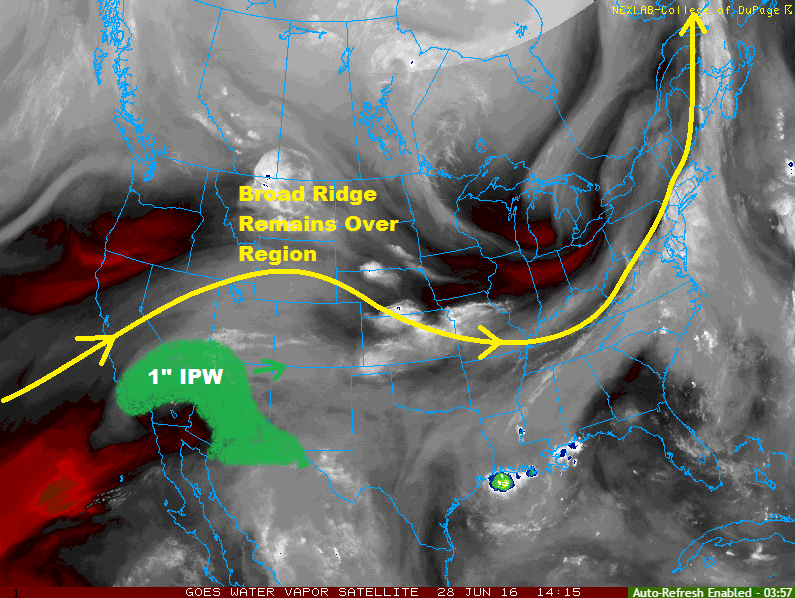
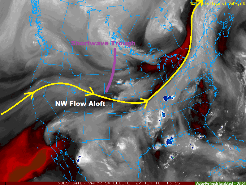
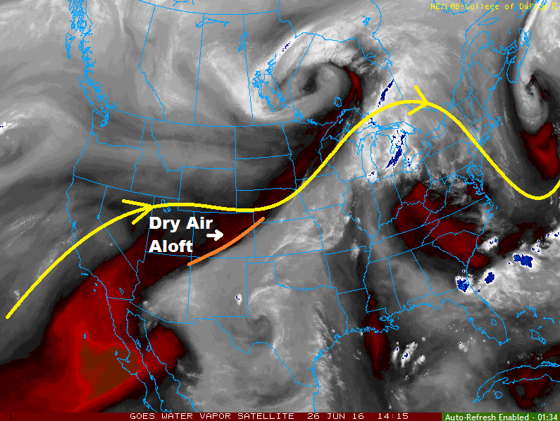
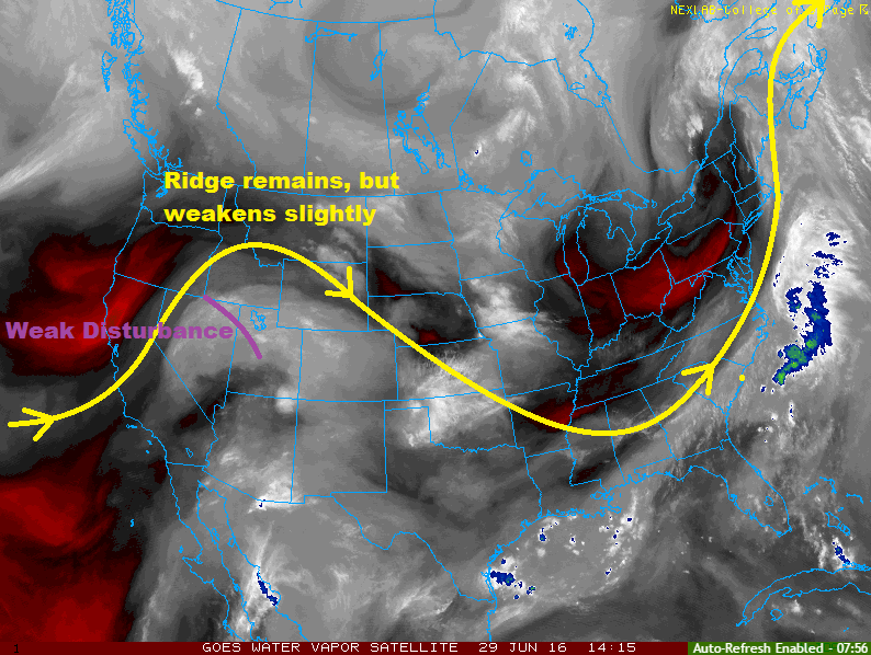
Current water vapor analysis shows the (slightly weakening) mid-/upper-level ridge still in place across the region today. Underneath the ridge, sufficient mid-level moisture remains across the state, while monsoonal moisture continues to seep into Colorado from the west/southwest. Embedded within the flow is a weak disturbance that will pivot out of Utah this morning and into Colorado this afternoon/evening. The disturbance will provide the support for more widespread showers/thunderstorms today across the High Country, as well as another day of scattered thunderstorms across eastern Colorado.

Across eastern Colorado, the concern for strong/severe storms exists again today, mainly across the Northeast Plains, Palmer Ridge, and northern/eastern extents of the Southeast Plains. The Urban Corridor has a lesser chance of getting in on the strong/severe storms, but the potential extends to those regions, as well. Generally speaking, the best coverage of showers/storms will be along/near the higher terrain, as well as over the preferred terrain of the Palmer Ridge, Cheyenne Ridge, and Raton Ridge, while the strongest storms will be further east where instability/moisture/wind shear will be best.

WV_20160629

From the Front Range/Southeast Mountains and westward, scattered-to-widespread showers and thunderstorms are expected this afternoon and evening, with a few showers lingering into the overnight hours. The main threats from these storms will be gusty winds and lightning, but locally heavy rainfall is a concern over southwestern Colorado where moisture will be best, thus the issuance of the low flood threat.

Today’s Flood Threat Map

For more information on today’s flood threat, see the map below (hover over threat areas for more details). For Zone-Specific forecasts, jump below the map.

Flood Threat Legend

Zone-Specific Forecasts

Urban Corridor, Northeast Plains, Palmer Ridge, Raton Ridge, and Southeast Plains:

Scattered showers and thunderstorms are expected to begin this afternoon, continuing into the evening and overnight hours. Ingredients are favorable for the production of isolated strong/severe thunderstorms during the afternoon hours, with the main threats being hail and strong winds, as well as locally heavy rainfall.

The main event looks to come after 8 PM tonight in the form of a thunderstorm complex rolling in from WY/NE and into northeast Colorado. Much like yesterday’s strong storms, this complex will follow much of the same path, producing large hail, strong/damaging winds and heavy rain.

Timing: 1 PM – 1 AM, with lingering showers/thunderstorms along/south of the Palmer Ridge into the early morning hours

Front Range and Southeast Mountains:

Scattered showers/thunderstorms are expected, beginning around lunchtime and continuing into the evening and nighttime hours. Isolated showers/weak thunderstorms will continue into the early morning hours. The Front Range will have the potential to see one or two strong/severe storms this afternoon/evening, producing strong winds, small hail, and dangerous lightning. Locally heavy rainfall is also a threat, thus the inclusion of the Front Range in the low flood threat. Maximum rain rates will be 1.0-1.6 inches/hour for the Front Range, and 0.6-0.8 inches/hour for the Southeast Mountains.

Timing: 11 AM – 10 PM, with a few lingering into the early morning

Northwest Slope, Northern Mountains, Central Mountains, San Juan Mountains, Southwest Slope, Grand Valley, and San Luis Valley:

Scattered-to-widespread showers/thunderstorms are expected, beginning around 11 AM and continuing into the evening hours. Overnight, showers/weak thunderstorms will become more isolated, but a few will linger into tomorrow morning. Generally speaking, the main threats from thunderstorms will be gusty winds, dangerous lightning, and small hail, but locally heavy rainfall is possible across southwestern Colorado. Maximum rain rates are as follows:

Northwest Slope, Northern Mountains, and Central Mountains: 0.4-0.8 inches/hour
San Luis Valley: 0.6-1.0 inches/hour
Grand Valley: 0.8-1.2 inches/hour
Southwest Slope and San Juan Mountains: 1.0-1.6 inches/hour

Timing: 11 AM – 10 PM, with isolated showers/weak thunderstorms continuing into tomorrow morning

FTB 06-28-2016: Two Distinct Low Flood Threat Areas

Issue Date: 6/28/2016
Issue Time: 10:21 AM

A LOW FLOOD THREAT IS ISSUED FOR PORTIONS OF NORTHEAST PLAINS, SOUTHWEST SLOPE, AND SAN JUAN MOUNTAINS.

Two distinct areas, for two distinct reasons, will feature low flood threats during this period. The Northeast Plains will experience a period very similar to yesterday’s isolated-to-scattered thunderstorms, which included a few severe storms and bouts with moderate-to-heavy rainfall. The other distinct area will be across southwestern Colorado, namely the Southwest Slope and San Juan Mountains regions. There, better moisture aloft is being transported in from the west/southwest (as shown by the water vapor image/annotations below).

During the afternoon, isolated-to-scattered showers/thunderstorms will be high-based across southwestern Colorado, mainly over the higher terrain. Gusty outflow winds in combination with the high-based thunderstorms producing lightning will heighten fire concerns, mainly over the lower elevations of the Southwest Slope. With that said, as the afternoon turns to evening, moisture will mix down as outflow helps to saturate the lower levels. This increase in the depth of moisture, particularly near the surface, will allow for locally heavy rainfall. Storm motions will help mitigate the flood threat somewhat, but a low flood threat is warranted.

WV_20160628

East of the mountains, today will be very similar to yesterday. The main difference is that moisture will be a bit less in comparison, especially along/near the higher terrain. This, combined with the northwest flow regime, will keep the stronger storms further to the east, mainly over the Northeast Plains. For the other regions (Palmer Divide, Urban Corridor, Southeast Plains, and Raton Ridge), isolated showers/thunderstorms will bring mainly gusty winds and lightning, with brief bouts of moderate rainfall. Relatively speaking, the Southeast Plains and Raton Ridge will see the least amount of activity.

For more details, please see the zone-specific discussions below.

Today’s Flood Threat Map

For more information on today’s flood threat, see the map below (hover over threat areas for more details). For Zone-Specific forecasts, jump below the map.

Flood Threat Legend

Zone-Specific Forecasts

Urban Corridor, Northeast Plains, Palmer Ridge, Raton Ridge, and Southeast Plains:

Isolated-to-scattered thunderstorms expected. The best coverage will occur over the Northeast Plains, as will the strongest storms. The main threats from storms over the Northeast Plains will be strong winds up to 60 mph, large hail (up to 2.5 inches in diameter), and a brief isolated tornado or two.

The Urban Corridor, Palmer Ridge, Raton Ridge, and Southeast Plains will see more isolated coverage, with more “garden variety” intensity. The main threats from these storms will be gusty winds, lightning, and small hail. Maximum rain rates are as follows:

Northeast Plains: 2.0-2.8 inches/hour
Urban Corridor, Palmer Ridge, and Raton Ridge: 0.4-0.8 inches/hour
Southeast Plains: 1.0-1.5 inches/hour

Timing: 2 PM – Midnight, with a couple isolated storms continuing over the Plains into the early morning hours

Front Range, Northern Mountains, Central Mountains, San Luis Valley, and Southeast Mountains:

Isolated-to-scattered showers/thunderstorms expected. Storms will develop over the higher terrain, briefly drifting over lower valleys. The main impacts from any activity will be gusty winds, lightning, and light rain. Maximum rain rates will be 0.5-0.8 inches/hour.

Timing: 11 AM – 10 PM

Northwest Slope and Grand Valley:

Mostly sunny and hot will be the main weather story today. Over the higher terrain, isolated, high-based, dry thunderstorms will develop this afternoon/evening. This will elevate fire concerns in these regions as gusty outflow winds and very little rain will accompany any cloud-to-ground lightning.

Timing: 2 PM – 10 PM

San Juan Mountains and Southwest Slope:

Isolated-to-scattered thunderstorms are expected, mainly over the higher terrain. During the afternoon, storms will be high-based, producing more wind and lightning than rain. As the afternoon turns to evening, however, moisture will mix down into the low-levels, providing the opportunity for locally heavy rainfall. Thus, the issuance of the low flood threat. Steep terrain, burn scars, and low lying areas will be the main areas of concern for any flood/heavy rain issues. Maximum rain rates will be 1.0-1.5 inches/hour.

Timing: 11 AM – 9 PM

FTB 06-27-2016: Low Flood Threat Returns

Issue Date: 6/27/2016
Issue Time: 9:05 AM

A LOW FLOOD THREAT IS ISSUED FOR PORTIONS OF URBAN CORRIDOR, FRONT RANGE, NORTHEAST PLAINS, PALMER RIDGE, AND SOUTHEAST PLAINS.

Current water vapor analysis shows the building ridge across the southwestern US with general trough-ing over the central US. Northwesterly flow aloft is in place over Colorado, while a shortwave trough pivots across the north-central US. In the wake of this shortwave trough, a cool front will push through eastern Colorado later this morning/early this afternoon, reinforcing easterly upslope flow and low-level moisture along the Front Range and eastward across the plains.

Steep lapse rates above the increase in moisture will support strong instability this afternoon across the Northeast Plains. Combined with sufficient wind shear, discrete supercell thunderstorms will be the preferred storm type, at least during the first few hours of storm activity. These storms will be capable of very large hail (up to 2.5 inches in diameter), periods of heavy rain, and isolated tornadoes. As the evening wears on, interactions between storms will lead to clusters, transitioning the main threat to damaging winds and hail up to 1.5 inches in diameter.

WV_20160627

Back across the Front Range/Urban Corridor/Palmer Ridge/Southeast Plains/Raton Ridge, moisture will be a bit less, leading to more moderate instability. Storms will be a bit less vigorous, with the main threats being hail (up to 1.5 inches in diameter), strong winds, and periods of moderate-to-heavy rainfall. Storm coverage will be more isolated-to-widely scattered in these regions, with the best relative coverage over the Palmer Ridge, and Southeast Plains as storms move into the region from the Northeast Plains.

West of the Continental Divide, a lack of moisture will keep the area mostly sunny and mainly dry, with a few isolated storms over the higher terrain. Any storm activity will be high-based, leading to more gusty winds and lightning than rain. For more details regarding timing and rain rates, please see the zone-specific discussions below.

Today’s Flood Threat Map

For more information on today’s flood threat, see the map below (hover over threat areas for more details). For Zone-Specific forecasts, jump below the map.

Flood Threat Legend

Zone-Specific Forecasts

Front Range, Urban Corridor, Northeast Plains, Palmer Ridge, Raton Ridge, Southeast Mountains, and Southeast Plains:

Isolated-to-widely scattered thunderstorms are expected to break up the otherwise partly sunny skies today. A couple strong/severe storms are a good bet across the Northeast Plains where the environment will support very large hail, damaging winds, and isolated tornadoes. Periods of heavy rain will also accompany these storms. For the other regions, thunderstorms will be more isolated and a bit less vigorous, but will still hold the potential for strong winds, hail, and periods of moderate-to-heavy rainfall. Maximum rain rates are as follows:

Northeast Plains: 2.0-3.0 inches/hour
Front Range: 1.0-1.5 inches/hour
Urban Corridor, Palmer Ridge, and Southeast Plains: 1.2-1.8 inches/hour
Southeast Mountains and Raton Ridge: 0.6-1.0 inches/hour

Timing: Noon – 9 PM for mountain regions, 1 PM – Midnight for others (with a few storms continuing over the Southeast Plains into the morning hours)

Northwest Slope, Northern Mountains, Central Mountains, Grand Valley, San Juan Mountains, Southwest Slope, and San Luis Valley:

Isolated, gusty thunderstorms possible over the higher terrain of the Northern Mountains, Central Mountains, San Juan Mountains, and Southwest Slope. All other locations will remain dry and hot. Skies will be mostly sunny across most locations, with partly sunny skies near the higher terrain seeing the isolated storm activity. Maximum rain rates will be 0.4-0.6 inches/hour.

Timing: Noon – 9 PM, with a couple lingering isolated storms over the San Juan Mountains into the early AM hours

FTB 06-26-2016: Fewer Thunderstorms Today

Issue Date: 6/26/2016
Issue Time: 10:05 AM

NO FLOOD THREAT IS FORECAST.

The water vapor image below tells the main story of today’s forecast as westerly flow aloft has continued to transport drier air into Colorado. The drier air, along with no disturbances to be found, will lead to a significant downtick in showers/thunderstorms as compared to the past couple of days. However, sufficient instability and moisture will remain for the production of isolated-to-widely scattered showers/storms across the following regions: Northeast Plains, Urban Corridor, Palmer Ridge, Front Range, Central Mountains, Southeast Mountains, San Juan Mountains, Raton Ridge, and Southeast Plains.

WV_20160626

Due to the overall reduction in deep moisture, especially in more flood susceptible areas, no flood threat is forecast. A couple of strong-to-severe storms will develop over the plains, but observed/forecast soundings suggest more of a damaging wind threat than heavy rain. Temperatures will rise a couple of degrees for most locations today, with the biggest jump expected across northeastern Colorado.

Today’s Flood Threat Map

For more information on today’s flood threat, see the map below (hover over threat areas for more details). For Zone-Specific forecasts, jump below the map.

Flood Threat Legend

Zone-Specific Forecasts

Northeast Plains, Urban Corridor, Palmer Ridge, Raton Ridge, and Southeast Plains:

Isolated-to-widely scattered showers/thunderstorms will break up the otherwise mostly sunny sky. Areas along/near the higher terrain of the Front Range/Southeast Mountains, as well as near the preferred terrain of the Cheyenne Ridge/Palmer Ridge/Raton Ridge will have the most coverage, relatively speaking, thanks to orographic influences. Microbursts are possible under the stronger storms, and gusty winds/lightning will be the main threats. Maximum rain rates are as follows:

Urban Corridor: 0.4-0.8 inches/hour
Palmer Ridge: 0.5-1.0 inches/hour
Northeast Plains: 1.0-2.0 inches/hour
Southeast Plains and Raton Ridge: 1.2-1.8 inches/hour

Timing: 1 PM – 9 PM

Outflow boundaries from afternoon convection across western KS/NE and southern WY will need to be monitored this evening. An isolated thunderstorm or two will be possible as they converge across the Northeast Plains/Palmer Ridge from 9 PM – 3 AM. If these storms develop, they will likely produce the heaviest rain of the day, with maximum rain rates of 1.5-2.0 inches/hour. These storms will not persist long, due to less instability after sunset and a neutral atmosphere above.

Front Range, Central Mountains, San Juan Mountains, San Luis Valley, and Southeast Mountains:

Isolated-to-widely scattered showers/thunderstorms are expected to develop this afternoon/evening. The main threats will be gusty winds/lightning as moisture is significantly lower than previous days. Maximum rain rates will be 0.3-0.6 inches/hour. The San Luis Valley will remain mainly dry, with areas near the surrounding higher terrain seeing the best chance for any storm activity.

Timing: Noon – 9 PM

Northern Mountains, Northwest Slope, Grand Valley, and Southwest Slope:

Mostly sunny and hot, with temperatures pushing a couple degrees warmer than yesterday. Isolated cumulus clouds will develop over the higher terrain of the Southwest Slope and Northern Mountains, with perhaps a few patches of virga underneath the high bases.