Issue Date: 7/31/2016
Issue Time: 9:15 AM
A LOW FLOOD THREAT IS FORECAST FOR PORTIONS OF THE GRAND VALLEY, SOUTHWEST SLOPE, SAN JUAN MOUNTAINS, CENTRAL MOUNTAINS, NORTHWEST SLOPE, NORTHERN MOUNTAINS, NORTHEAST PLAINS, PALMER RIDGE, AND SOUTHEAST PLAINS.
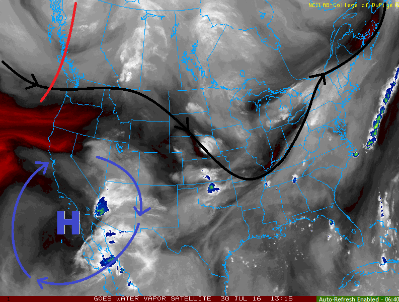
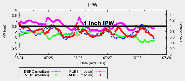
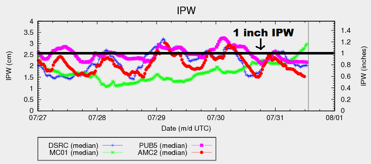
Deeper moisture has overspread much of western Colorado, as evidenced by the sharp rise in Grand Junction IPW (see chart below, green line). Values above 1 inch, especially across the Western Slope, signify a developing flood threat, and such is the case today. East of the mountains, moisture is less, mainly due to a drier low-level profile. This morning’s (6 AM MDT) sounding from Denver shows that much of the moisture resides between 3.5 km and 5.5 km aloft, which will temper rain rates along the Front Range/Southeast Mountains/adjacent lower elevations a bit. Storm coverage will be scattered-to-widespread across the mountains, with areas along/near the mountains seeing scattered showers/storms.
Further east, low-level moisture is better across the plains. Precipitable water values above 1 inch will be widespread across the eastern third of Colorado, with the far eastern plains pushing 1.25-1.4 inches. Thunderstorm coverage will be fairly isolated across the eastern third of Colorado due to weak capping aloft and generally meager instability, so no flood threat attends much of the area.
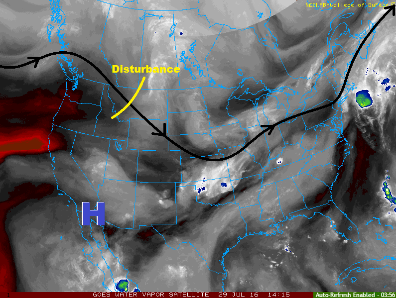
The exception is the far Northeast Plains, and perhaps far enough south to graze the Palmer Ridge and Southeast Plains, where a weak disturbance is forecast to move overhead this afternoon and evening, providing the best opportunity for strong storms across eastern Colorado. The moisture described above will fuel fairly efficient rainfall, and slow-moving storms are a concern as the steering flow will only be about 10-15 mph. This scenario is the driving factor behind the low flood threat for these areas. For more information regarding timing and rain rates, please see the zone-specific forecast discussions below.
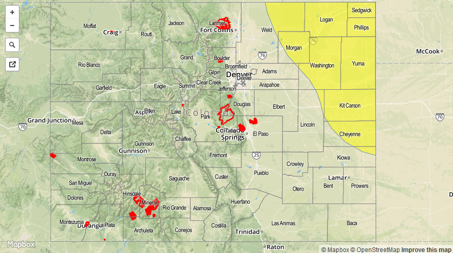
Today’s Flood Threat Map
For more information on today’s flood threat, see the map below (hover over threat areas for more details). For Zone-Specific forecasts, jump below the map.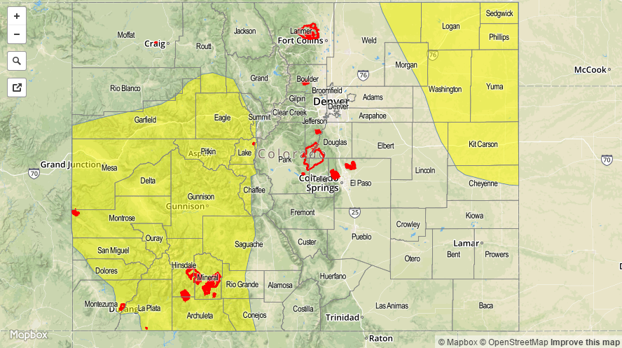

Zone-Specific Forecasts
Front Range, Urban Corridor, Raton Ridge, and Southeast Mountains:
Scattered showers/thunderstorms are expected, producing garden variety results. Brief periods of moderate rainfall, gusty winds, and lightning are the main threats. Slow-moving storms may result in street ponding in areas with poor drainage, but flooding that would warrant the issuance of a flood threat is not expected. Maximum rain rates will be 0.4-0.6 inches/hour.
Timing: 11 AM – 1 AM for the mountains, 1 PM – 9 PM for the Raton Ridge, and Noon – 10 PM for the Urban Corridor
Northeast Plains, Palmer Ridge, and Southeast Plains:
Isolated-to-widely scattered storms are expected, with the best coverage occurring across the Northeast Plains. A disturbance aloft will help kick off stronger thunderstorms, producing bouts with heavy rain, strong winds, and hail. Slow-moving storms are the main concern behind the low flood threat. Maximum rain rates are 1.4-1.8 inches/hour.
Timing: 1 PM to 1 AM for the Northeast Plains, 3 PM – 10 PM for the Palmer Ridge, and 1 PM – Midnight for the Southeast Plains
Northern Mountains, San Juan Mountains, Central Mountains, Southwest Slope, Northwest Slope, Grand Valley, and San Luis Valley:
Scattered showers/thunderstorms are expected throughout today and into tonight as deeper moisture fuels activity. Locally heavy rainfall is a concern, especially for steeper terrain areas that received rainfall yesterday and/or this morning. Rain rates will not be particularly impressive due to generally weak instability, but slow-moving storms are a concern. Maximum rain rates will be 0.8-1.2 inches/hour.
Timing: 11 AM – 10 PM, with a few showers/storms lingering over the higher terrain in southern regions into the early morning hours