FTB 09-09-2016: Cooler and Dry with One Exception

Issue Date: 9/9/2016
Issue Time: 9:15 AM

NO FLOOD THREAT IS FORECAST.

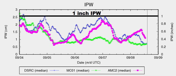
The main weather story today will be the passage of a cool front from the north. There is not much moisture associated with the front, so it will result in cooler temperatures and little else. You can see just how dry the atmosphere is over much of Colorado in the IPW graph below; Boulder, Grand Junction, and Shriever AFB are all hovering around 0.3 inches. A few mid-/high-level clouds will develop over the Front Range/Southeast Mountains and adjacent lower elevations in the slightly upslope flow regime behind the front, but no precipitation is expected. Over the High Country and Western Slope, gusty winds will be noticeable, but with lesser wind speeds than yesterday afternoon.

ipw_20160909

The lone exception to today’s dry forecast will be across the Raton Ridge and far Southeast Plains where a bit better moisture will hang on. Most of the activity is expected to remain south and east of the area in neighboring states, but one or two isolated showers/thunderstorms cannot be ruled out. Rain rates are expected to stay below flash flood thresholds, so no flood threat is forecast today.

Today’s Flood Threat Map

For more information on today’s flood threat, see the map below (hover over threat areas for more details). For Zone-Specific forecasts, jump below the map.

Flood Threat Legend

Zone-Specific Forecasts

Urban Corridor, Palmer Ridge, and Northeast Plains:

Mostly sunny and dry conditions will prevail today, with cooler temperatures expected. A few mid-/high-level clouds will be noted near the mountains and along the Palmer ridge. Overnight, temperatures will fall to seasonably cool values, with many locations dipping into the 40s.

Raton Ridge and Southeast Plains:

Mostly sunny and dry will be the main weather story today, with an isolated thunderstorm or two possible during the afternoon/evening hours. Brief moderate-to-heavy rain up to 0.4-0.8 inches/hour will be all the atmosphere can muster, which is below flash flood thresholds.

Timing: 4 PM – 11 PM

Front Range, Southeast Mountains, Northern Mountains, Northwest Slope, San Juan Mountains, Southwest Slope, San Luis Valley, Central Mountains, and Grand Valley:

Sunny, dry, and gusty winds will be the main weather impacts during this forecast period. Temperatures will be cooler than yesterday due to the cool frontal passage. Overnight lows will be on the chilly side, with a Freeze Watch issued for portions of the Northwest Slope and Northern Mountains.

FTB 09-08-2016: Warm and Dry, Isolated Storm Possible near CO/KS Border

Issue Date: 9/8/2016
Issue Time: 9:25 AM

NO FLOOD THREAT IS FORECAST.

Dry, westerly flow across Colorado will result in dry and warm conditions for the vast majority of the state. Relative humidity values will fall below 30% for much of the state, even back into the 10-15% range for portions of the Western Slope and High Country. Persistent gusty winds will stay mainly north of the state, but a brief window of gusty winds mixing to the surface across the Northwest Slope and Northern Mountains will heighten fire weather concerns in those regions during the afternoon/early evening. Downslope winds along the Front Range and adjacent plains will push the remaining moisture from this morning to the east, leaving the region under mostly sunny and warm conditions today.

ipw_20160908

Near the CO/KS border, low-level easterly flow will fight to maintain some moisture in far eastern Colorado. This will result in the appearance of a dryline/surface convergence boundary laying across easternmost counties. Along and east of this boundary, an isolated thunderstorm or two cannot be ruled out this afternoon/evening. Dewpoints in the 50s will provide enough low-level moisture for brief periods of moderate-to-heavy rainfall, but total column moisture and upper-support will be lacking so no flood threat is forecast.

Today’s Flood Threat Map

For more information on today’s flood threat, see the map below (hover over threat areas for more details). For Zone-Specific forecasts, jump below the map.

Flood Threat Legend

Zone-Specific Forecasts

Urban Corridor, Palmer Ridge, and Raton Ridge:

Mostly sunny and dry conditions will prevail today as westerly flow dries out the region. Temperatures will bump a few degrees higher than yesterday, and it looks like a great night for Thursday Night Football between the Broncos and Panthers.

Northeast Plains and Southeast Plains:

Mostly sunny and dry will be the main weather story today, especially for the western half of the regions. Near the CO/KS border, along and east of a dryline, an isolated thunderstorm or two will be possible during the afternoon and evening hours. Maximum rain rates will be 0.8-1.2 inches/hour, with any heavy rainfall lasting only a brief period of time.

Timing: 2 PM – 10 PM

Front Range, Southeast Mountains, Northern Mountains, Northwest Slope, San Juan Mountains, Southwest Slope, San Luis Valley, Central Mountains, and Grand Valley:

Mostly sunny and dry will be the name of the game today, with a brief window of heightened fire danger across the Northwest Slope and Northern Mountains this afternoon as relative humidity values drop into the 10-15% range. Clear skies will remain overnight, allowing temperatures to drop to seasonably cool values.

FTB 09-07-2016: Isolated Thunderstorm Possible in the South

Issue Date: 9/7/2016
Issue Time: 9:15 AM

NO FLOOD THREAT IS FORECAST.

The mid-level southwesterly flow of moisture from remnants of Hurricane Newton will continue today, although low-level moisture advection that has been persistent over the last few days and produced a few strong storms yesterday has moved out of much of the region to the east ahead of the eastward progression of the northern U.S. trough. The graph below illustrates the sudden drop in low-level moisture at two locations beginning at about 02:00 UTC as the trough moved through the region. With a lack of sufficient low-level moisture, the result should be a dry and mild day with plenty of sunshine in much of the eastern half of the state, although a thin upper-level cirrus cloud deck may be present over some locations.

GPSMET IPW (09072016)

A small amount of low-level moisture will likely be advected into extreme southern portions of the Raton Ridge and Southeast Plains later today, which may spark off a few isolated thunderstorms in the afternoon. Continued westerly flow will bring sunny and dry conditions to the High Country and Western Slopes.

Today’s Flood Threat Map

For more information on today’s flood threat, see the map below (hover over threat areas for more details). For Zone-Specific forecasts, jump below the map.

Flood Threat Legend

Zone-Specific Forecasts

Urban Corridor, Northeast Plains, Southeast Plains, Palmer Ridge, Raton Ridge:

Most of the region will be mild and dry today, with a chance of an isolated thunderstorm in southern portions of the Raton Ridge and Southeast Plains. Maximum rain rates will remain well below flooding thresholds. An upper-level cirrus cloud deck may form throughout the remainder of the region, but sunshine will prevail most of the day. There is no flood threat today.

Northern Mountains, Central Mountains, Southeast Mountains, Front Range, San Juan Mountains, San Luis Valley, Northwest Slope, Grand Valley, Southwest Slope:

Dry westerly flow will persist over these regions, which will bring sunny and dry conditions throughout the day today. There is no flood threat today.

FTB 09-06-2016: More Showers/Storms, a Couple Will be Strong/Severe

Issue Date: 9/6/2016
Issue Time: 9:40 AM

A LOW FLOOD THREAT IS FORECAST TODAY FOR PORTIONS OF THE RATON RIDGE, SOUTHEAST PLAINS, NORTHEAST PLAINS, AND PALMER RIDGE REGIONS.

Mid-level moisture will return to the state today as a result of both the upper-trough (shown in yellow lines/arrows) sliding east and Hurricane Newton’s (circled in black) moist plume rotating across southeast Colorado. In the low-levels, better moisture will exist across eastern Colorado thanks to upslope flow behind a surface front transporting central plains moisture into the area. Additionally, good instability and wind shear will provide the necessary ingredients for a couple storms to become strong-to-marginally severe over the Plains/Palmer Ridge, with the main threats being strong winds and large hail. In the upper-levels, the right rear entrance of a jet streak will provide weak support for showers/thunderstorms, which will help bring about more coverage than previous days.

WV_20160906

Overall, the High Country and Western Slope will remain mainly quiet today, with a few isolated-to-widely scattered showers/weak thunderstorms over the higher terrain of the San Juan Mountains, Southeast Mountains, and Front Range. Further east over the lower elevations, isolated-to-scattered showers and garden-variety thunderstorms will dot the area, with a couple strong/severe thunderstorms mixed in. Storms will remain mainly high-based, but one or two may become rooted near the surface, which would pose a low-end, low flood threat. Generally speaking, rainfall rates from most activity will be well below flash flood thresholds. For more information, please see the zone-specific forecast discussions below.

Today’s Flood Threat Map

For more information on today’s flood threat, see the map below (hover over threat areas for more details). For Zone-Specific forecasts, jump below the map.

Flood Threat Legend

Zone-Specific Forecasts

Urban Corridor, Northeast Plains, Palmer Ridge, Southeast Plains and Raton Ridge:

The main weather impact today will be the increase in clouds across the area and slightly cooler temperatures behind the passing surface front. A few isolated-to-scattered showers/thunderstorms are expected, with the best chance of occurrence along/near the Palmer Ridge and across the far Southeast Plains and Raton Ridge (where Hurricane Newton’s moist plume exists). A couple strong/severe storms will mix in with the otherwise garden variety activity, and these storms are the ones that pose the low-end, low flood threat. Maximum rain rates are as follows:

Urban Corridor: 0.4-0.6 inches/hour
Palmer Ridge and Raton Ridge: 0.6-1.0 inches/hour
Northeast Plains: 1.2-1.6 inches/hour
Southeast Plains: 1.5-2.0 inches/hour

Timing: Noon – Midnight

Front Range, Southeast Mountains, Northern Mountains, Northwest Slope, San Juan Mountains, Southwest Slope, San Luis Valley, Central Mountains, and Grand Valley:

Breezy conditions will be the name of the game for most, with dry weather expected as low-level relative humidity values remain in the 10-20% range. Red Flag Warnings exist for portions of the Northwest Slope, Grand Valley, Southwest Slope, and Central Mountains regions. The return of some mid-level moisture, combined with marginal low-level moisture and weak support aloft, will allow for a couple isolated showers over the higher terrain of the San Juan Mountains, Southeast Mountains, and Front Range. Don’t expect much in the way of rainfall, as sprinkles and a brief light shower will be all the environment can muster.

Timing: 11 AM – 9 PM