FTB 09-29-2016: Colorado Contrast

Issue Date: 9/29/2016
Issue Time: 9:40 AM

A LOW FLOOD THREAT IS FORECAST FOR PORTIONS OF THE NORTHWEST SLOPE, GRAND VALLEY, AND SOUTHWEST SLOPE.

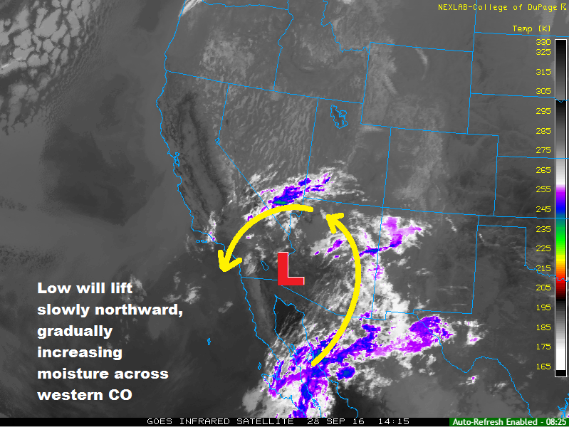
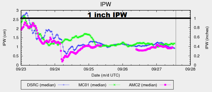
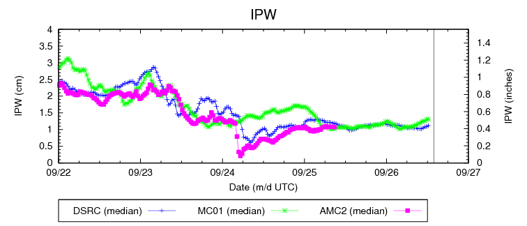
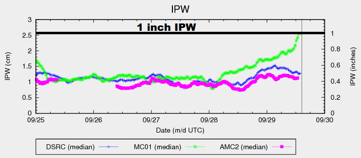
Stuck between an upper-level ridge over the central US and an upper-level trough off the West Coast, the flow across Colorado will be southerly today/tonight. This will continue to bring in subtropical moisture (associated with the weakening upper-level low) to western Colorado, while drier air remains in place for areas east of the mountains. This stark contrast between the two regions is illustrated well by the IPW graph below, showing the dramatic increase in moisture over Grand Junction (green line), while measurements from Boulder (blue line) and Schriever AFB (pink line) have remained fairly steady for the past few days.

ipw_20160929

The continued stream of subtropical moisture into western Colorado will lead to scattered showers/isolated thunderstorms throughout the day/night, producing mainly light-to-moderate rainfall. During the afternoon and early evening hours, thunderstorms will produce their most efficient rainfall. However, storms will be moving northward at a good pace, minimizing the flooding threat. Overall, a low flood threat is warranted, but it is important to note that any flooding issues will likely be localized ponding on roadways and in poorly drained areas.

Meanwhile, due to the southerly flow aloft, showers/storms are expected to stay confined along and west of the Continental Divide, with perhaps one or two spill-over showers into the Front Range/Southeast Mountains. East of those regions, the lower elevations will be controlled by high pressure and a stable air mass, keeping conditions dry and mostly sunny. For more details, including rain rates and timing, please see the zone-specific forecast discussions below.

Today’s Flood Threat Map

For more information on today’s flood threat, see the map below (hover over threat areas for more details). For Zone-Specific forecasts, jump below the map.

Flood Threat Legend

Zone-Specific Forecasts

Urban Corridor, Palmer Ridge, Northeast Plains, Raton Ridge and Southeast Plains:

Sunny and dry will once again be the main weather story today, with high temperatures pushing a few degrees above climatological average. Winds will be a bit gustier than previous days, so keep that in mind if you plan on being outdoors.

Front Range, Southeast Mountains, and San Luis Valley:

Mostly sunny skies and mainly dry conditions will be the name of the game today, with only one or two “spill-over” showers possible over the higher terrain. Even so, with near-surface levels remaining dry, any shower activity will be high-based, producing gusty winds and a sprinkle or two.

Timing: Noon – 10 PM

Northern Mountains, Northwest Slope, San Juan Mountains, Southwest Slope, Central Mountains, and Grand Valley:

Scattered showers/isolated thunderstorms are expected throughout today/tonight, with the best coverage occurring over westernmost regions. Rainfall will be most efficient during the afternoon and early evening hours, bringing the potential for localized flooding issues on roadways and poorly drained areas. Overall, the flood threat can be characterized as a “low-end, low flood threat.” Maximum rain rates are as follows:

Northwest Slope, Grand Valley, and Southwest Slope: 0.6-1.0 inches/hour
Central Mountains, Northern Mountains, and San Juan Mountains: 0.4-0.7 inches/hour

Timing: 11 AM – 11 AM

FTB 09-28-2016: A Few Showers/Thunderstorms Return

Issue Date: 9/28/2016
Issue Time: 9:12 AM

NO FLOOD THREAT IS FORECAST.

The upper-level ridge that was largely responsible for the recent stretch of pleasant weather will remain in control of the forecast across eastern Colorado, keeping dry conditions present for another day. A few mid-/high-level clouds, mainly along/near the mountains, will be noted, but that’s it. On the other hand, changes are afoot for the High Country and Western Slope in the form of a slowly moving upper-level low. It is easy to pick out the low in the infrared imagery below, as well as the associated subtropical moisture plume. As the low lifts northward, mid- and upper-level moisture will stream into the state, bringing an increase of mid-/upper-level clouds to western regions.

ir_20160928

A few showers and isolated thunderstorms are expected across the Southwest Slope, San Juan Mountains, Grand Valley, and Central Mountains regions this afternoon and evening, with a couple spotty showers continuing overnight over the higher terrain. Rain rates are expected to remain well below flash flood thresholds, thanks in part to the low-levels remaining fairly dry. For more details, including rain rates and timing, please see the zone-specific forecast discussions below.

Today’s Flood Threat Map

For more information on today’s flood threat, see the map below (hover over threat areas for more details). For Zone-Specific forecasts, jump below the map.

Flood Threat Legend

Zone-Specific Forecasts

Urban Corridor, Palmer Ridge, Northeast Plains, Raton Ridge and Southeast Plains:

Mostly sunny skies and dry conditions will be the main weather story again today, leading to another pleasant late-September day. Highs over the eastern plains will be a few degrees cooler than yesterday, with other regions experiencing highs similar to those yesterday.

Front Range, Southeast Mountains, and San Luis Valley:

Dry conditions will be the main story again today, along with a slight increase of mid- and high-level clouds (as compared to yesterday). High temperatures will be similar to yesterday’s readings, as well.

Northern Mountains, Northwest Slope, San Juan Mountains, Southwest Slope, San Luis Valley, Central Mountains, and Grand Valley:

Increasing clouds and dry for most, with a few showers/isolated thunderstorms expected across western Colorado. The higher terrain of the Southwest Slope and San Juan Mountains regions will see the most activity, relatively speaking, with only isolated showers/thunderstorms over the higher terrain of the Central Mountains. As the day turns to night, a few showers will spread to the Northwest Slope and western extents of the Northern Mountains regions.

Dry low-levels will subdue rainfall rates/totals, resulting in maximum rain rates of 0.15-0.30 inches/hour, with most rain rates checking in below 0.10 inches/hour.

Timing: Noon – 9 PM, with a relative minimum in activity between 9 PM and 2 AM, and then a slight uptick in the early morning hours as a weak disturbance lifts northward across the area from the south/southwest.

FTB 09-27-2016: Another Pleasant Day Ahead

Issue Date: 9/27/2016
Issue Time: 9:10 AM

NO FLOOD THREAT IS FORECAST.

An upper-level ridge and dry air (see IPW chart) will remain in charge of the forecast during this forecast period, leaving Colorado with another beautiful, early-Fall day. Underneath mostly sunny skies, temperatures will climb to above-average values statewide, pushing into the mid-80s for some locations across the eastern plains. For towns/communities across the High Country, temperatures will range from the high 50s to the lower 70s. A few mid-/high-level clouds will drift into southwestern Colorado later tonight due to moisture circulating around the upper-level low currently centered over the Baja Peninsula. That will be the most Mother Nature has to offer during this forecast period.

ipw_20160927

Today’s Flood Threat Map

For more information on today’s flood threat, see the map below (hover over threat areas for more details). For Zone-Specific forecasts, jump below the map.

Flood Threat Legend

Zone-Specific Forecasts

Urban Corridor, Palmer Ridge, Northeast Plains, Raton Ridge and Southeast Plains:

Sunny skies and late-September warmth will be the name of the weather game today, with high temperatures in the 70s and 80s across the area. Overnight lows will be a few degrees warmer than last night, owing to the better warming taking place this afternoon.

Front Range, Southeast Mountains, Northern Mountains, Northwest Slope, San Juan Mountains, Southwest Slope, San Luis Valley, Central Mountains, and Grand Valley:

Mostly sunny skies and pleasant temperatures will be the weather story today. A few high-level clouds will be present during the afternoon, with the introduction of additional mid-/high-level clouds later tonight/overnight for southwest Colorado. A few streaks of virga may be present over the higher terrain of the Southwest Slope and San Juan Mountains regions late this afternoon and during the evening hours, but that will be it.

FTB 09-26-2016: Great Early Fall Day

Issue Date: Monday, September 26th, 2016
Issue Time: 9:15AM MDT

~ Flooding is not expected today for all regions.

Dry weather will continue today as any chances of precipitation remain well to the south and east and as the High Pressure centered over the Great Basin develops further. Since the circulation around a high pressure is clockwise, and in combination with the associated ridge at upper levels, winds will tend to be out of the northwest today as Colorado is at the leading edge of this high pressure. The air mass that is associated with the high pressure will remain dry and stable as can be seen in the IPW graph below, producing what is going to shape up to be a very nice day for all regions. Frost conditions from yesterday’s lows will yield to slightly warmer temperatures today (4 to 8 degrees higher than yesterday) that should continue to warm throughout the week.

11931pwv

Today’s Flood Threat Map

For more information on today’s flood threat, see the map below (hover over threat areas for more details). For Zone-Specific forecasts, jump below the map.

Flood Threat Legend

Zone-Specific Forecasts

All Zones:

It will be dry and sunny today with light winds coming out of the northwest with the approach of a High Pressure from the west. Look for temperatures to be seasonal with a 4 – 8 degree warmup from yesterday. The influence of the Low that formed to the southwest will not impact the region today as all moisture will remain to the south. Enjoy another great day for golf if you can!