Issue Date: Wednesday, August 23, 2017
Issue Time: 10:45AM MDT
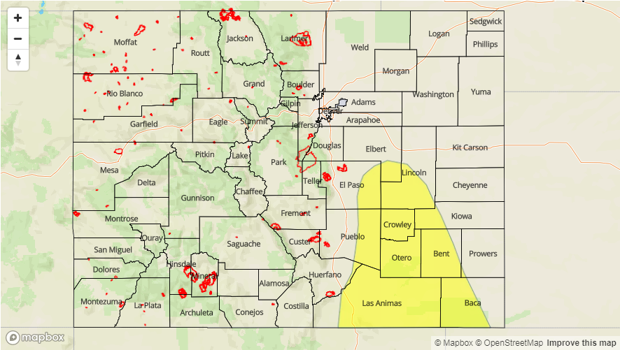
— LOW flood threat for Palmer Ridge, Southeast Plains and Raton Ridge
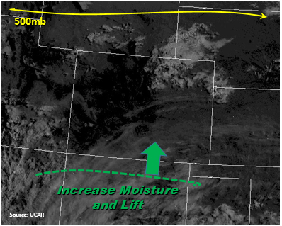
The state will be under light W/NW flow under the upper-level ridge today, which center has shifted a bit to the west. As seen on the water vapor image below, this will advect drier air into the mid-levels. This is expected to mix out moisture at the surface over the entire state excluding the northeast corner of the state and the Raton Ridge/western Southeast Plains. Precipitable Water (PW) is currently at 0.87 inches in Grand Junction and 0.7 inches in Denver. Even with low-level moisture mixing out in these areas throughout the day, there will still be enough residual moisture for showers over the higher terrains and adjacent plains. However, most storms today are expected to produce more wind than heavy rainfall. A lee trough is expected to set itself up over the far eastern plains and with strong southerly surface winds east of it. This will advect more moisture northwards from NE New Mexico where Tds are currently in the mid to upper 60s. Where PW is forecasted to be greater than 1 inch this afternoon/evening is marked on the map below.
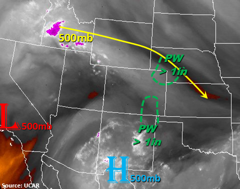
The weak upper-level disturbance from yesterday will move over northern CO today, which may enhance storms that form with the diurnal flow over this area. Storms are expected to be most numerous over this area as well as the southern Southeast Mountains. A fair amount of instability with increased daytime heating and minor shear will be present over the NW corner of the state and Southeast Plains this afternoon. This is the same area where PW is expected in increase to 1.2 inches. Storms that move off the higher terrains into these areas or storms that form over these areas from outflow boundaries will be capable of producing gusty winds, hail up to 0.75 inches and heavy, local precipitation. Faster storm motion is expected over the NE corner of the state, so 1-hour rain rates are not expected to exceed 1.5 inches. Thunderstorms are expected to continue overnight in the SE plains where localized amounts are expected to exceed 2.5 inches. Since the Arkansas River base flow has been able to recede, major riverine flooding is not expected. There is a Low flood threat for today.
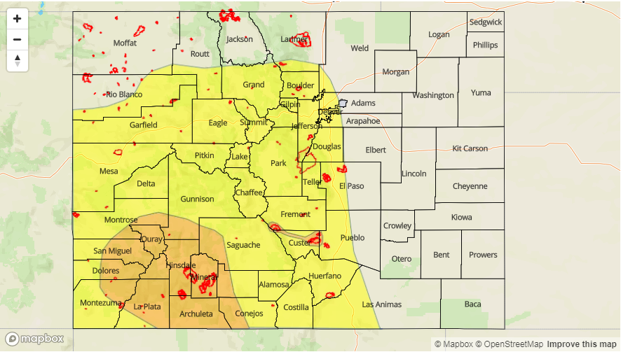
Today’s Flood Threat Map
For more information on today’s flood threat, see the map below (hover over threat areas for more details). For Zone-Specific forecasts, scroll below the map.

Zone-Specific Forecasts:
Front Range, Urban Corridor, Palmer Ridge, Northeast Plains, Southeast Mountains, Raton Ridge, Southeast Plains:
Sunny this morning becoming partly cloudy this afternoon. Storms are expected to be most numerous over the northern mountains and southern SE Mountains. Threats include small stream and road flooding as well as field ponding. Gusty winds and hail up to 0.75 inches are possible with stronger thunderstorms. Burn scars need to continue to be monitored closely. Storms over the SE Plains are expected to continue into the overnight hours with localized storm totals greater than 2.5 inches. 1-hour rain rates will be up to 1.7 inches (east) and 0.7 inches (west). A Low flood threat has been issued.
Primetime: 1:30PM to 4AM
Northwest Slope, Grand Valley, Southwest Slope, Northern Mountains, Central Mountains, San Juan Mountains, San Luis Valley:
Cloudy over the NW corner of the state this morning. Showers expected to fire over the higher terrain around noon but will produce more wind that rain today. 1-hour rain rates up to 0.7 inches (north) and 0.5 inches (south). Flooding is not expected today.
Primetime: 11AM to 9PM