FTB 08-31-2017: Disturbance To Trigger Widespread Showers/Storms, But Intensity Limited

Issue Date: Thursday, August 31, 2017
Issue Time: 9:35AM MDT

MODERATE flood threat for Junkins and Beulah Hill burn scars
LOW flood threat for Hayden Pass burn scar

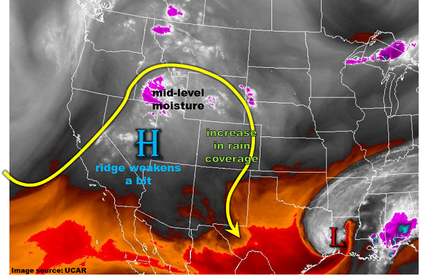
Changes are on the way this morning for Colorado’s weather. As shown in the water vapor image, below, a strong shortwave disturbance has made it to the Great Basin as of this morning. The dynamics with this disturbance are forcing upward motion to its east – seen by the wide swath of mainly mid-level clouds across UT, WY and northern CO. Precipitable water values have increased slightly to 0.82 inches at Grand Junction (mostly mid-level moisture with surface dew point of only 36 F) and 0.65 inches at Denver. As the disturbance continues to move eastward, it will generate widespread afternoon and evening showers and thunderstorms. The highest coverage will be over the High Country where instability will be uncapped. Farther east of the Plains, limited instability will only allow for isolated to widely scattered showers and perhaps a weak thunderstorm.

Rainfall rates this afternoon are expected to stay below flood threat levels, with the only exception being across the burn scars of the Sangre de Cristo and Wet mountains. These fresh scars only require 0.5 inches per hour of rainfall to cause mud flows and flash flooding. This appears probable today, especially over the Wet Mountains. Thus, a Moderate flood threat has been posted for the Junkins and Beulah Hill scars, while a Low threat has been posted for the Hayden Pass scar.

Today’s Flood Threat Map

For more information on today’s flood threat, see the map below (hover over threat areas for more details). For Zone-Specific forecasts, scroll below the map.

Flood Threat Legend

Zone-Specific Forecasts:

Front Range, Urban Corridor, Palmer Ridge, Northeast Plains, Southeast Mountains, Raton Ridge, Southeast Plains:

Partly cloudy this morning, then increasing cloudiness with numerous showers and thunderstorms possible. Highest coverage will be over the higher terrain east of the Continental Divide as well as the Cheyenne, Palmer and Raton ridges. Farther east, coverage will be isolated to scattered. Max 1-hour rain rates up to 0.9 inch closer to the foothills and 1.3 inches across the eastern plains. Max 24-hour rainfall up to 1.3 inches possible across the High Country. Gusty winds could accompany the strongest storms. A Moderate flood threat has been issued for the Junkins and Beulah Hill scars, while a Low threat has been issued for the Hayden Pass scar for mud flows and flash flooding.

Primetime: 1PM to 9PM

Northwest Slope, Grand Valley, Southwest Slope, Northern Mountains, Central Mountains, San Juan Mountains, San Luis Valley:

Partly to mostly cloudy with numerous showers and thunderstorms likely this afternoon. Highest coverage will be over the foothills and higher terrain. Max 1-hour rainfall up to 0.75 inches is possible, with max 24-hour rainfall up to 1.2 inch especially over higher elevation locations. Gusty winds will accompany the strongest cells. Flooding is not expected today.

Primetime: 12PM to 9PM

FTB 08-30-2017: Storm Coverage To Increase, But Still No Flood Threat

Issue Date: Wednesday, August 30, 2017
Issue Time: 9:48AM MDT

— Flooding is NOT expected today

As shown in the water vapor image, below, a few changes are noted in this morning’s atmospheric analysis over western North America. First, the strong upper-level ridge that has been around for the last 48-72 hours is slowly weakening and will continue to weaken throughout the day. Meanwhile, a modest shortwave disturbance is entering the California coast. Weak lift and moisture convergence is enhancing mid-level moisture over the northern Great Basin. Some of this moisture will make it into Colorado by later this afternoon. Precipitable water has increased to 0.64 inches (from 0.5 inches 24 hours ago) at Grand Junction and 0.65 inches at Denver. However, most of this moisture is in the mid-levels and despite plenty of morning sunshine, instability will once again be limited today.

Wrapping everything together, we expect an increase in shower and weak thunderstorm coverage today, especially over the higher terrain as the increase in mid-level moisture will help storms stay intact. However, with subsidence still being prevalent and only weak instability, expect a continuation of light to moderate rainfall rates. Thus, flooding is once again not expected today.

Today’s Flood Threat Map

For more information on today’s flood threat, see the map below (hover over threat areas for more details). For Zone-Specific forecasts, scroll below the map.

Zone-Specific Forecasts:

Front Range, Urban Corridor, Palmer Ridge, Northeast Plains, Southeast Mountains, Raton Ridge, Southeast Plains:

Mostly sunny this morning, then partly cloudy with scattered showers and weak thunderstorms possible. Highest coverage will be over the higher terrain east of the Continental Divide as well as the Cheyenne, Palmer and Raton ridges. Max 1-hour rain rates up to 0.8 inches closer to the foothills and 1.2 inches across the eastern plains. Gusty winds could accompany the strongest storms. Flooding is not expected today.

Primetime: 1PM to 9PM

Northwest Slope, Grand Valley, Southwest Slope, Northern Mountains, Central Mountains, San Juan Mountains, San Luis Valley:

Sunny early, then partly to mostly cloudy with scattered showers and thunderstorms likely this afternoon. Highest coverage will be over the San Juans, Central Mountains and Northern Mountains. Max 1-hour rainfall up to 0.6 inches is possible, with max 24-hour rainfall up to 1 inch especially over higher elevation locations. Gusty winds will accompany the strongest cells. Flooding is not expected today.

Primetime: 12PM to 9PM

FTB 08-29-2017: Persistent Pattern: Hot Out West, Isolated T-Storms East

Issue Date: Tuesday, August 29, 2017
Issue Time: 9:40AM MDT

— Flooding is NOT expected today

This morning’s water vapor image, below, shows a very persistent atmospheric pattern across the central and western US. The remnants of Hurricane Harvey continue to be a very serious threat across the Gulf Coast states. However, drying is noted on the west side of the storm’s center, and Harvey’s moisture will never make it to Colorado. Instead, subsidence will continue to be the main player today, supporting mainly clear skies and hot weather west of the Continental Divide with isolated storms possible over the higher elevations and foothills to the east. Morning Precipitable Water (PW) values were 0.62 and 0.47 inches at Denver and Grand Junction, respectively. This is down 10-20% from yesterday. PW is expected to stay steady today. With plenty of morning sunshine, expect weak instability and upslope flow to generate isolated to scattered storms mainly over the higher elevations and foothills east of the Continental Divide. A few storms could make it farther eastward off the Cheyenne, Palmer and Raton ridges. However, only short-term moderate rainfall is expected. Flooding is not expected today.

The main headline today will continue to be above average temperatures statewide, but especially west of the Continental Divide where high temperatures of up to 15F above normal are expected.

Today’s Flood Threat Map

For more information on today’s flood threat, see the map below (hover over threat areas for more details). For Zone-Specific forecasts, scroll below the map.

Zone-Specific Forecasts:

Front Range, Urban Corridor, Palmer Ridge, Northeast Plains, Southeast Mountains, Raton Ridge, Southeast Plains:

Mostly sunny this morning, then partly cloudy with isolated to scattered showers and weak thunderstorms possible. Highest coverage will be over the higher terrain east of the Continental Divide as well as the Cheyenne, Palmer and Raton ridges. Max 1-hour rain rates up to 0.75 inches (below 7,000 feet) and 0.5 inches (above 7,000 feet), though most everyone will stay dry. Gusty winds will accompany the strongest storms. Flooding is not expected today.

Primetime: 1PM to 8PM

Northwest Slope, Grand Valley, Southwest Slope, Northern Mountains, Central Mountains, San Juan Mountains, San Luis Valley:

Sunny early with isolated showers and a weak thunderstorm possible this afternoon. Highest coverage will be over the San Juans. Max 1-hour rainfall up to 0.4 inches is possible. Gusty winds will accompany the strongest cells. Flooding is not expected today.

Primetime: 12PM to 8PM

FTB 08-28-2017: Strong Ridge To Continue Supporting Generally Dry Weather

Issue Date: Monday, August 28, 2017
Issue Time: 9:55AM MDT

— Flooding is NOT expected today

This morning’s water vapor image, below, continues to show the remnants of Hurricane Harvey as the dominant feature across the central United States. However, closer to home, Colorado will continue to be under the firm control of a seasonably strong upper-level ridge centered over the Great Basin. Subsidence will support mainly clear skies with a few afternoon clouds and isolated storms possible over the higher elevations of southern Colorado. Morning Precipitable Water (PW) values were 0.70 and 0.50 inches at Denver and Grand Junction, respectively. PW is expected to decrease slowly through the day as drier northerly flow is advected into the state. A weak frontal boundary, a residual from yesterday’s cool front, was noted in southeast Colorado. This is expected to “wash out” by early afternoon, replaced by the climatologically favored lee side trough across eastern Colorado. The end result will be downsloping flow that will suppress storm activity anywhere outside of the high country (mainly Palmer Ridge, Southeast Mountains and San Juans). Storms that do develop will cause brief moderate rainfall, along with gusty winds. Flooding is not expected today.

Today’s Flood Threat Map

For more information on today’s flood threat, see the map below (hover over threat areas for more details). For Zone-Specific forecasts, scroll below the map.

Zone-Specific Forecasts:

Front Range, Urban Corridor, Palmer Ridge, Northeast Plains, Southeast Mountains, Raton Ridge, Southeast Plains:

Mostly sunny this morning, then partly cloudy with isolated showers and weak thunderstorms possible. Highest coverage will be over the higher terrain of the Southeast Mountains and Palmer Ridge. Max 1-hour rain rates up to 0.5 inches (north) and 0.7 inches (far south). Gusty winds will accompany the strongest storms. Flooding is not expected today.

Primetime: 12PM to 8PM

Northwest Slope, Grand Valley, Southwest Slope, Northern Mountains, Central Mountains, San Juan Mountains, San Luis Valley:

Sunny early with isolated showers and a weak thunderstorm possible this afternoon. Highest coverage will be over the San Juans. Max 1-hour rainfall up to 0.5 inches is possible. Gusty winds will accompany the strongest cells. Flooding is not expected today.

Primetime: 12PM to 8PM