FTB 09-08-2017: Scattered Afternoon/Evening Storms, But Rain Rates Once Again Limited

Issue Date: Friday, September 8, 2017
Issue Time: 9:45AM MDT

— Flooding is NOT expected today

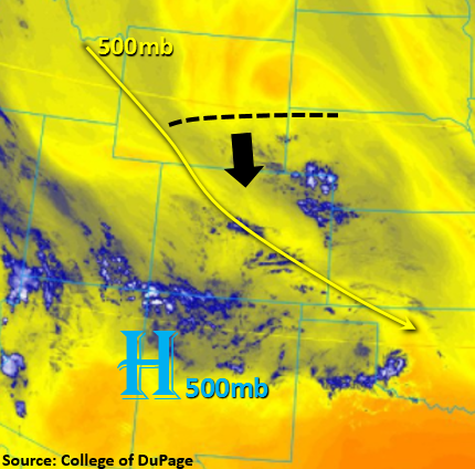
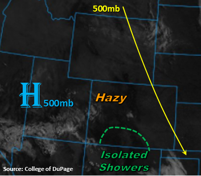
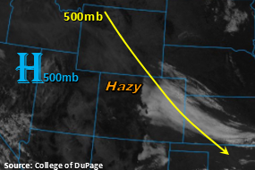
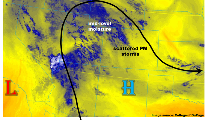
An upper-level disturbance, one that will likely affect Colorado’s weather on and off for the next 5-7 days, has made it to the southwest US coast. As shown in the water vapor image, below, southerly flow ahead of the disturbance is pushing monsoon-origin moisture northward into AZ/NV/UT. However, a weak ridge of high pressure is centered over western Colorado, implying that the brunt of this moisture will not make it into our state today. Instead, plenty of mid-level moisture is noted across the Western Slope this morning. Precipitable Water (PW) values were 0.59 and 0.75 inches at Denver and Grand Junction from the morning balloon launches. PW is not expected to change much, meaning that moisture levels will not be high enough for heavy rainfall today. With abundant sunshine this morning, expect scattered to numerous showers and thunderstorms across most of the High Country this afternoon and evening. Some storms are expected to make it farther east especially over the Cheyenne and Palmer ridges. However, rain rates will stay in the light to moderate intensity and flooding is not expected today.

Today’s Flood Threat Map

For more information on today’s flood threat, see the map below (hover over threat areas for more details). For Zone-Specific forecasts, scroll below the map.

Zone-Specific Forecasts:

Southeast Mountains, Raton Ridge, Southeast Plains, San Juan Mountains, Front Range, Urban Corridor, Palmer Ridge, Northeast Plains:

Sunny early, then turning partly cloudy with scattered showers and thunderstorms this afternoon and evening. Highest coverage will be over the High Country and adjacent foothills. Max 1-hour rainfall up to 0.6 inches. Later this evening, isolated to scattered storms could continue in the Northeast Plains, especially along the WY/CO border with max 1-hour rainfall up to 1.1 inches. Flooding is not expected today.

Primetime: 1PM to 11PM

Northwest Slope, Grand Valley, Southwest Slope, Northern Mountains, Central Mountains, San Luis Valley:

Partly cloudy early then scattered showers and thunderstorms this afternoon. Highest coverage will be over the higher elevations and foothills. Max 1-hour rain rates up to 0.5 inches. Gusty winds could accompany the strongest cells. Flooding is not expected today.

Primetime: 1PM to 8PM

FTB 09-07-2017: Increased Rainfall Coverage over the Southeast and San Juan Mountains

Issue Date: Thursday, September 7, 2017
Issue Time: 09:55AM MDT

Flooding is NOT expected today

Haze will persist statewide through Friday. The heavier low-level smoke will continue to be over the northwest portion of the state. Most stations in this region are currently reporting haze with visibility around 9 miles. Visibility will continue to decrease throughout the afternoon especially near and southeast of the fires along the WY/CO border. Overnight and early this morning, some moisture has worked its way into the southwest corner of the state with southwest surface winds. This is currently producing light showers and cloud cover.

Northwest flow aloft will continue throughout the day. On the water vapor image below, there is a visible shortwave over WY that will work its way south. This extra upper-level energy is expected to enhance upslope flow along the southern mountains. Thus, shower and thunderstorm potential is more numerous than on Wednesday. Showers will move SE off the higher terrains, but are expected to quickly dissipate over the eastern plains. With Precipitable Water (PW) values up to 0.7 inches over the southern mountains, brief heavy rainfall may be possible with max 1-hr totals up to 0.5 inches. A fair amount of instability is expected to form with daytime heating, so stronger thunderstorms may produce gusty winds. Storms should end shortly after sundown.

Today’s Flood Threat Map

For more information on today’s flood threat, see the map below (hover over threat areas for more details). For Zone-Specific forecasts, scroll below the map.

Zone-Specific Forecasts:

Southeast Mountains, Raton Ridge, Southeast Plains, San Juan Mountains:

Partly cloudy this morning with more clouds burning off after sunrise. Shower and thunderstorm coverage this afternoon is expected to be more numerous with a passing upper-level wave. Max 1-hr rain rates up to 0.5 inches are possible. Flooding is not expected today.

Primetime: 1PM to 9PM

Front Range, Urban Corridor, Northeast Plains, Palmer Ridge, Central Mountains:

Sunny this morning becoming partly cloudy over the mountains this afternoon. Increased coverage of rain expected over the southern portions of the Front Range and Central Mountains. Max 1-hr totals up to 0.25 inches. Flooding is not forecasted today.

Primetime: 2PM to 8PM

Northwest Slope, Grand Valley, Southwest Slope, Northern Mountains, San Luis Valley:

Sunny and hazy this morning. Decreased visibility in the Northern Mountains and Northwest slope are likely this afternoon. Visibility will be reduced to the 6 mile range and may even be less near the fires along the CO/WY border.  Temperatures are expected to be persistent with highs 5-10F above climatology. Flooding is not expected today.

Primetime: 2PM to 8PM

FTB 09-06-2017: Light Showers over the Southern High Country and a Rebound of High Temperatures

Issue Date: Wednesday, September 6, 2017
Issue Time: 09:50AM MDT

Flooding is NOT expected today

Mostly clear skies with the exception of a few high clouds over the state. Some haze is still being reported over the northwest corner of the state and high country from the wildfires up north. Low temperatures overnight should start to recover quickly this morning with the sunrise. High temperatures will also be on the uptick today after a nice break from the heat yesterday. 700mb temperatures are about 6C degrees warmer than yesterday putting the eastern portion of the state much closer to climatology. Northwest flow at the upper-levels will occur again today with the strong 500mb ridge that extends from the Pacific Northwest to the Desert Southwest. This ridging pattern will produce another day with hazy conditions statewide, except over the Northeast Plains, which should experience some relief from the smoke. The smoke will again be confined to the upper-levels with the exception of the northwest corner of the state. Visibility this afternoon is forecasted to be in the 6-7 mile range, which is similar to yesterday.

Precipitable Water values near climatology are expected (0.6 inches) over the southern portion of the state. With some instability building over the southern mountains, a few showers are likely to form again this afternoon with upslope flow. Rainfall totals will be limited, but stronger showers could produce up to 0.6 inches. Showers should quickly end after sundown.

Today’s Flood Threat Map

For more information on today’s flood threat, see the map below (hover over threat areas for more details). For Zone-Specific forecasts, scroll below the map.

Zone-Specific Forecasts:

Southeast Mountains, Raton Ridge, Southeast Plains, San Juan Mountains:

Sunny today becoming partly cloudy this afternoon over the mountains. A few showers are expected to initiate later this afternoon over the southern Southeast Mountains, Raton Ridge and San Juan Mountains. Max 1-hr rain rates up to 0.6 inches (east) and 0.3 (west). Flooding is not expected today.

Primetime: 12:30PM to 8PM

Front Range, Urban Corridor, Northeast Plains, Palmer Ridge:

Sunny this morning becoming partly cloudy over the mountains this afternoon. Reduction in smoke likely over the Northeast Plains and all smoke should be confined to the upper-levels of the atmosphere. An isolated shower over the southern Front Range is possible, but only trace amounts of rainfall are expected. Flooding is not forecasted today.

Primetime: 1PM to 8PM

Northwest Slope, Grand Valley, Southwest Slope, Northern Mountains, San Luis Valley, Central Mountains:

Sunny and hazy throughout the day. The Central Mountains will become partly cloudy this afternoon. To the north, afternoon visibility will be reduced to the 6-7 mile range.  High temperatures will continue to be about 5-10F above climatology. Flooding is not expected today.

Primetime: 1PM to 8PM

FTB 09-05-2017: Cold Front Passage Brings Relief from the Heat

Issue Date: Tuesday, September 5, 2017
Issue Time: 10:05AM MDT

Flooding is NOT expected today

The passage of a cold front late yesterday afternoon and overnight has helped decrease the low-level haze as well as the temperature this morning for the eastern portion of the state. A thick stratus deck is present east of the Divide due to the moistening of the lower atmosphere with the passage of the cold front. This will provide relief east of the Continental Divide from the heat wave that has impacted the state the last few days. High temperatures today will be 15-20F lower than yesterday with cloudy skies expected most of the day. While smoke is still being advected into the state from the fires up north, it should be mostly confined to the mid- and upper-levels increasing visibility. West of the Continental Divide, haze will continue in the low-levels further north with the high pressure to the west. The shallow cold front was not able to penetrate the Continental Divide, so expect another day of warm temperatures.

In the wake of the cold front, more stable air has established itself in the eastern portion of the state. This should confine showers to the southern high terrain once again. Expecting showers to produce little in the way of rain, but gusty winds could accompany the stronger storms. Storms should quickly end around sundown this evening with low temperatures in the 30s for the higher terrains. There is no flood threat today.

Today’s Flood Threat Map

For more information on today’s flood threat, see the map below (hover over threat areas for more details). For Zone-Specific forecasts, scroll below the map.

Zone-Specific Forecasts:

Southeast Mountains, Raton Ridge, San Juan Mountains, San Luis Valley, Southwest Slope:

Cloudy east of the Divide this morning becoming partly cloudy this afternoon. Showers and thunderstorms are expected to initiate this afternoon with the diurnal heating pattern and stronger storms will likely produce gusty winds. Max 1-hr rain rates up to 0.6 inches. Flooding is not expected today.

Primetime: 12:30PM to 8PM

Front Range, Urban Corridor, Northeast Plains, Palmer Ridge, Southeast Plains:

Mostly cloudy this morning with temperatures 15-20F cooler than yesterday. Reduction in low-level smoke is expected, but some haze is still likely. An isolated shower may form over the Front Range, but will only produce trace amounts of rain. Flooding is not expected today.

Primetime: 1:30PM to 8PM

Northwest Slope, Grand Valley, Northern Mountains, Central Mountains:

Sunny this morning with temperatures in the 90s over the lower elevations. Low-level smoke will continue to reduce visibility, especially north. An isolated showers may occur over the Central Mountains, but only trace amounts of rainfall are expected.

Primetime: 1PM to 8PM