FTB 09-20-2017: Mostly Sunny with Continuing Downslope Winds

Issue Date: Wednesday, September 20, 2017
Issue Time: 10:35 AM MDT

— Flooding is NOT expected today

Currently, cooler temperatures after the passage of the cold front yesterday evening and a few clouds over the northwest corner of the state. The cold front dramatically cooled temperatures 15-20F yesterday and produced a lot of blowing dust during the evening. It also helped moisten the lower levels of the atmosphere a bit. This moistening helped produce light showers overnight in the northern high terrains and is responsible for the continued cloud cover this morning. Despite temperatures in the 40s and low 50s this morning, high temperatures will return to average this afternoon.

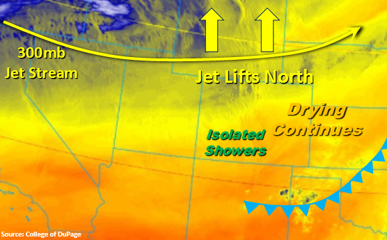
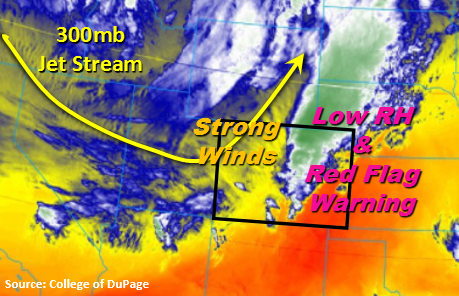
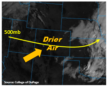
The trough to our northwest will begin to dig south today, and the jet stream will lift to our north. This should decrease wind speeds throughout the day, especially when compared to yesterday. Higher dew points and cooler temperatures will also give us a little relief from fire danger. However, windy conditions will still exist today, so use extra caution with open flames. Aloft, winds will shift from west to southwesterly as the day continues. Not much in the way of mid-level energy this afternoon, but models hint at a weak shortwave over the southwest corner of the state, which may help initiate some showers. Low dew points and mid-level drying will limit how much rainfall reaches the surface, but isolated totals up to 0.25 inches are possible. Elsewhere across the state, downsloping winds will keep skies clear and continue to promote atmospheric drying. Surface wind speeds will be highest today over the NW corner, mountain peaks and the Palmer Ridge. Isolated gusts are expected to be 35 mph over the lower elevations and up to 50 mph over the higher terrains. Flooding is not expected today.

Today’s Flood Threat Map

For more information on today’s flood threat, see the map below (hover over threat areas for more details). For Zone-Specific forecasts, scroll below the map.

Zone-Specific Forecasts:

Front Range, Urban Corridor, Northeast Plains, Palmer Ridge, Southeast Mountains, Raton Ridge, Southeast Plains:

Sunny throughout the day with increasing winds this afternoon, especially over the higher peaks and the Palmer Ridge. Downsloping winds will continue to promote atmospheric drying, so no rainfall is expected. No Red Flag Warning today, but gusty conditions could still easily spread fires and extra caution should be used with any open flame. Flooding is not expected today.

Primetime: 5PM to 10PM

Northwest Slope, Grand Valley, Southwest Slope, Northern Mountains, Central Mountains, San Luis Valley, San Juan Mountains, Central Mountains:

Clouds over the northern mountains expected to clear later this morning. Gusty winds over the northwest corner of the state will decrease throughout the day as the jet lifts north. This afternoon some showers could develop over the San Juan Mountains with the arrival of a weak shortwave. However, mid-level drying and low surface dew points will limit how much rain reaches the surface. Isolated amounts up to 0.25 inches are possible. Flooding is not expected today.

Primetime: 4PM to 11PM

FTB 09-19-2017: Gusty Winds and High Fire Danger

Issue Date: Tuesday, September 19, 2017
Issue Time: 10:20 AM MDT

— Flooding is NOT expected today

High winds expected today as the upper level trough brushes Colorado’s northern border. The approaching jet stream has streaks up to 140 knots with 110-120 knot values over the northwest corner of the state. Higher elevations in the mountains and along the Palmer Divide could see gusts in the 40-50 mph range. The 700mb direction and speed today is one associated with stronger winds along the Front Range as well. Thus, downslope westerly/southwest flow is expected across the state today, which should keep things quite dry. The exception is north over the CO/WY border where a shortwave moves through early this evening, which may help initiate some isolated storms. With low dew point values and high-cloud bases, most precipitation will evaporate before reaching the ground. However, some measurable precipitation could fall along and near the Gore Range.

The increased downslope flow will create very low relative humidity this afternoon and increase temperatures a few degrees just east of the mountains. Low humidity combined with fast wind speeds will generate extreme fire danger across the state today. Burning should be avoided and extra caution should be used with any open flame. A wind advisory is in effect until 7PM tonight for the northwest corner of the state as the jet stream moves in and mixes down through the afternoon. Sustained southwest winds of 20 to 35 mph and gusts up to 50 mph are expected. Winds should begin to die down late tonight with the decoupling of the upper and lower atmospheres. Flooding is not expected today.

Today’s Flood Threat Map

For more information on today’s flood threat, see the map below (hover over threat areas for more details). For Zone-Specific forecasts, scroll below the map.

Zone-Specific Forecasts:

Front Range, Urban Corridor, Northeast Plains, Palmer Ridge, Southeast Mountains, Raton Ridge, Southeast Plains:

Sunny throughout the day with strong SW winds. The downsloping winds will cause temperatures closer to the mountains to increase a few degrees. A Red Flag Warning has been issued through this evening, so please avoid burning and use extreme caution with any open flame. An isolated storm along the northern Front Range with trace amounts of precipitation may be possible this evening. Flooding is not expected today.

Primetime: 5PM to 10PM

Northwest Slope, Grand Valley, Southwest Slope, Northern Mountains, Central Mountains, San Luis Valley, San Juan Mountains, Central Mountains:

Sunny this morning with winds increasing; especially over the northwest corner of the state. Winds are expected to be 20-35 mph with winds gusting as high as 50 mph. Some clouds and minimal rain are possible over the Northern Mountains (Gore Range) this evening. Precipitation amounts are expected to be under 0.25 inches. Flooding is not expected today.

Primetime: 5PM to 10PM

FTB 09-18-2017: Statewide Drying brings Plentiful Sunshine and Warm Temperatures

Issue Date: Monday, September 18, 2017
Issue Time: 10:05 AM MDT

— Flooding is NOT expected today

The visible satellite image below shows mostly clear skies over the state with the exception of the northeast corner of the state where fog was reported earlier this morning. This quickly burned off with the increasing temperatures post sunrise. Aloft, a more zonal pattern will dominate the weather this morning and turn more southwesterly this afternoon. The southwesterly flow will continue to dry out the upper levels and mix out surface moisture throughout the day. The highest dew points, over the eastern plains, are only expected to be in the 40s by later this afternoon and will decrease rapidly to the west. Precipitable Water (PW) values this morning were measured around 0.55 inches for both Denver and Grand Junction.

With the drying, we expect rainfall totals today to range from none to minimal. The best chances for measurable rain will be west of the Continental Divide over the higher terrains, but totals are expected to be under 0.1 inches. Higher temperatures statewide are also forecasted with highs over the lower elevations reaching the mid-80s and the mountains reaching the 70s. As the next system approaches from the Pacific Northwest, surface winds will start increasing tomorrow with the tight gradient. A fire weather watch is in place and is expected to become a Red Flag Warning tomorrow. On and off breezy conditions are expected through Friday. More details on the critical fire danger situation will be in tomorrow’s FTB.

Today’s Flood Threat Map

For more information on today’s flood threat, see the map below (hover over threat areas for more details). For Zone-Specific forecasts, scroll below the map.

Zone-Specific Forecasts:

Front Range, Urban Corridor, Northeast Plains, Palmer Ridge, Southeast Mountains, Raton Ridge, Southeast Plains:

Sunny throughout the day with some cloud cover over the mountains this afternoon. An isolated shower may be possible later this afternoon or evening, but only trace amounts of precipitation are expected. Winds are expected to start increasing from the southwest tonight. Flooding is not expected today.

Primetime: 3PM to 9PM

Northwest Slope, Grand Valley, Southwest Slope, Northern Mountains, Central Mountains, San Luis Valley, San Juan Mountains, Central Mountains:

Sunny this morning with increasing clouds over the higher terrains this afternoon. Drying will limit shower coverage this afternoon, but some isolated showers over the climatologically favored regions may occur. Storm totals are expected to be under 0.1 inches. Flooding is not expected today.

Primetime: 1PM to 9PM

FTB 09-17-2017: A Few Stronger Storms for Eastern Colorado

Issue Date: Sunday, September 17th, 2017
Issue Time: 9:00 AM MDT

— Flooding is NOT expected today

A couple ingredients will come together for a more active period, and each have been highlighted on the surface map below. First of all, southwesterly flow aloft (red arrow) has increased in the wake of yesterday’s exiting trough and today’s approaching shortwave disturbance. This has helped to increase moisture across the state as well, pushing precipitable water values near, or just above, normal for the date. At the surface, a quasi-stationary front is draped along the I-25 corridor, allowing moist upslope flow to continue into eastern Colorado. The different flow directions create a “turning” with height, which will provide the necessary shear for a few strong-to-severe thunderstorms across eastern Colorado today/tonight.

Across the high country, showers and thunderstorms are expected to be of the garden variety, producing brief periods of rainfall and gusty winds. All activity across the state is expected to move east-northeastward at a decent pace, limiting rainfall in any one location, so flash flooding is not a concern. For more details, please see the zone-specific forecast discussions below.

Today’s Flood Threat Map

For more information on today’s flood threat, see the map below (hover over threat areas for more details). For Zone-Specific forecasts, scroll below the map.

Zone-Specific Forecasts:

Urban Corridor, Palmer Ridge, Raton Ridge, Northeast Plains, and Southeast Plains:

Scattered showers and thunderstorms are expected, first impacting western areas near the interface with the mountains and moving east-northeastward with time. A few strong-to-severe storms are likely for areas along/south of I-70, with the main threats being large hail, strong winds, and an isolated tornado or two. Brief periods of heavy rain will accompany stronger storms, but storm motions will limit the amount of rainfall in any one location. Due to this, flash flooding is not a concern, but isolated locations of street flooding in poorly drained areas are possible. Maximum rain rates are as follows:

Urban Corridor: 0.5-0.8 inches/hour
Palmer Ridge: 0.5-1.0 inches/hour
Northeast Plains, Southeast Plains, and Raton Ridge: 0.8-1.25 inches/hour

Timing: 1 PM – 10 PM for the Urban Corridor, Noon – Midnight for the Raton Ridge, 2 PM – Midnight for the Palmer Ridge, and 2 PM – 3 AM for the Southeast Plains and Northeast Plains

Northern Mountains, Northwest Slope, Front Range, Southeast Mountains, Central Mountains, San Luis Valley, San Juan Mountains, Grand Valley, and Southwest Slope:

Scattered showers and thunderstorms are expected today, beginning later this morning and continuing into the nighttime hours. A couple showers/weak thunderstorms may persist into the early morning hours tomorrow over the higher elevations of central Colorado. As mentioned above, storm motions will keep storms from producing flash flooding, but brief periods of heavy rain will attend the strongest storms. Otherwise, gusty winds and lightning will be the main threats. Maximum rain rates are as follows:

Northwest Slope: 0.05-0.15 inches/hour
Northern Mountains, Front Range, Central Mountains, and Southeast Mountains: 0.5-0.9 inches/hour
San Juan Mountains, Southwest Slope, Grand Valley, and San Luis Valley: 0.4-0.8 inches/hour

Timing: 11 AM – 9 PM, with a few lingering showers/weak thunderstorms into the early morning hours.