FTB 05-15-2019: Another Hot, Spring Day with Isolated PM Storms

Issue Date: Wednesday, May 15th, 2019
Issue Time: 8:20AM MDT

–Flooding is NOT expected today

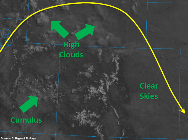
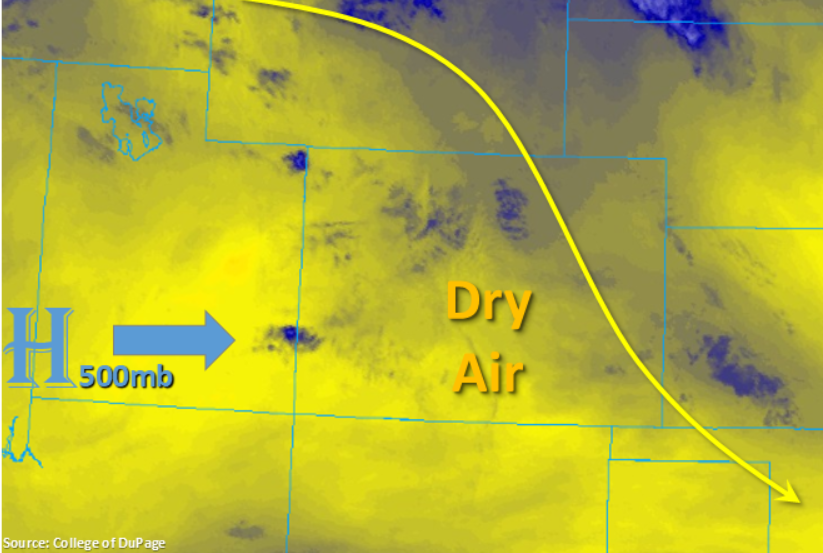
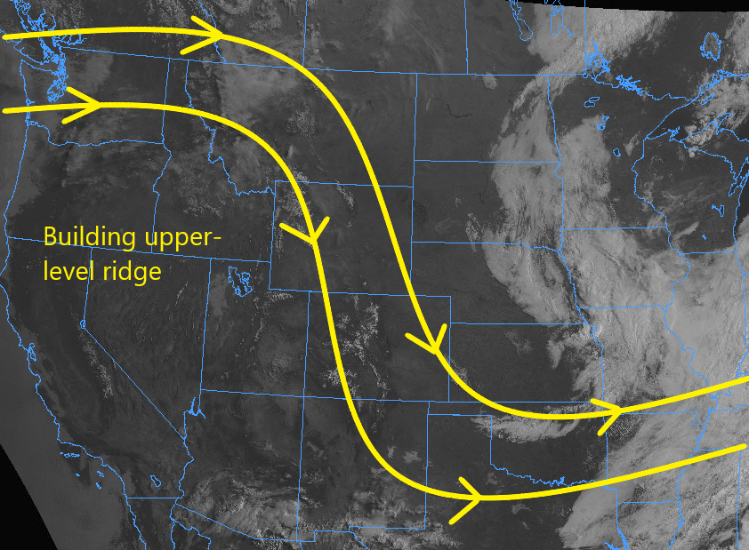
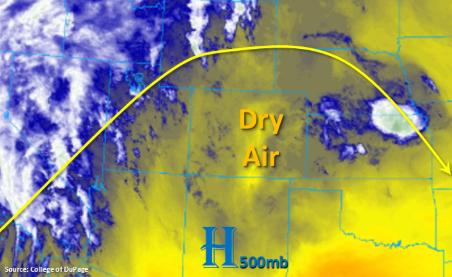
The water vapor imagery below shows the next trough setting up over the west coast. However, Colorado will spend today under the ridge, which translates to another day of sunshine and above average temperatures across the state. Flow aloft will remain westerly over the eastern Colorado, which will move the mass of dry air marked in the water vapor imagery below into the adjacent plains. This should really limit the measurable rainfall and thunderstorm activity over the adjacent plains and far eastern plains this afternoon. This also means some strong gusts may be possible as the storms evaporate.

This afternoon, scattered thunderstorm are expected to pop up over the mountains. Again, only limited residual moisture remains under the ridge, so not expecting much accumulation and forecasting limited coverage of the storms. Activity is forecast to slightly increase over the western high terrains with more southwesterly flow aloft in place. The highest accumulations should be near and along the Continental Divide, though most storms will only produce trace amounts and produce some gusty winds. Flooding is not expected.

Today’s Flood Threat Map

For more information on today’s flood threat, see the map below. For Zone-Specific forecasts, scroll below the map.


Zone-Specific Forecasts:

Front Range, Southeast Mountains, Urban Corridor, Palmer Ridge, Raton Ridge, Southeast Plains, Northeast Plains:

Scattered showers and thunderstorms are expected to pick up again this afternoon over the mountains. Overall, there is a slight decrease in moisture from yesterday, so not expecting much accumulation over the mountains or as the storms move into the adjacent plains. However, some gusts are possible with the evaporation of storms as 25 mph gusts were recorded yesterday and the atmosphere is much drier today. Not much thunderstorm activity is expected over the far eastern plains either, although there is a slight chance for some isolated rainfall along the Colorado/Kansas border with totals up to 0.15 inches possible. Accumulations up to 0.1 inches (west) are forecast though most storms will only produce a sprinkle or two. Storm activity will quickly decrease as the sun sets. Flooding is not forecast.

Primetime: 1:30PM to 9PM

Northwest Slope, Grand Valley, Southwest Slope, Northern Mountains, Central Mountains, San Juan Mountains, San Luis Valley:

Increased cloud cover is expected over the lower elevations of western Colorado this afternoon into tomorrow as the next system starts to move east. For today, high temperatures should be around or slightly above yesterday’s highs. Scattered storms are expected over the higher terrains again this afternoon favoring the Central Mountains. Accumulation is forecast to be under 0.1 inches though some isolated totals around 0.2 inches are feasible near the Divide. Gusts up to 55 mph are also possible as storms evaporate. Flooding is not forecast today.

Primetime: 2PM to 9PM

FTB 05-14-2019: Repeat Pattern of Monday as the Ridge Axis Moves Overhead

Issue Date: Tuesday, May 14th, 2019
Issue Time: 8:15AM MDT

–Flooding is NOT expected today

With the ridge axis directly over Colorado by this afternoon, expecting another day of above average temperatures and abundant sunshine statewide. The surface high pressure will rotate over the Arizona and New Mexico border, which should bring in a little mid-level energy to northern Colorado for storms and increased cloud cover this afternoon. Flow aloft will be northwesterly (east) and more westerly (west) this afternoon, which will hold the dry air mass in place. This morning in Denver, PW was measured at 0.38 inches with drier air just above the surface. While there is limited low level moisture, still expecting scattered storm activity this afternoon and evening favoring the high terrains including the Cheyenne, Palmer and Raton Ridges. A few weak storms may also be possible over the eastern plains as models have been hinting at convergence near Cheyenne, Kit Carson and Kiowa counties. Similar to yesterday, thunderstorms and rainfall will be high-based, so expecting low accumulations and some brief gusty winds under the virga. As anticipated, flooding is not forecast today.

Today’s Flood Threat Map

For more information on today’s flood threat, see the map below. For Zone-Specific forecasts, scroll below the map.

Zone-Specific Forecasts:

Front Range, Urban Corridor, Northern Mountains, Southeast Mountains, Palmer Ridge, Raton Ridge, Southeast Plains, Northeast Plains:

Activity will pick up again this afternoon over the mountains with the diurnal flow and some mid-level energy. Best chance for accumulation is over the northern high terrains in this area where up to 0.25 inches are possible. As storms move into the adjacent plains, they will likely survive only over the higher ridges and not much accumulation is expected. A few storms may also be possible over the plains, but all totals are expected to remain under 0.15 inches. Storm activity will decrease with sundown, so overnight rainfall and flooding are not forecast.

Primetime: 2PM to 10PM

Northwest Slope, Grand Valley, Southwest Slope, Central Mountains, San Juan Mountains, San Luis Valley:

High temperatures and plentiful sunshine to start the day. Cloud cover is anticipated to increase this afternoon over the northwest corner of the state with an approaching wave. However, only trace amounts of rainfall are forecast for these areas. Therefore the cloud cover will mostly be shade from the afternoon sun. High temperatures are expected to reach the mid-80°Fs over the lower elevations and 60°F in the mountain valleys. Isolated totals up to 0.1 inches are possible over the Central and San Juan Mountains. Flooding is not forecast today.

Primetime: 3PM to 8PM

FTB 05-13-2019: Ridge Continues to Produce Above Average Temperatures to Start the Week

Issue Date: Monday, May 13th, 2019
Issue Time: 8:15AM MDT

–Flooding is NOT expected today

Colorado continues to reside under a high pressure system to start the week. This will bring dry, NNW flow into the state, which is shown by the yellow in the water vapor imagery below. Some pockets of residual moisture (blue) are helping produce cloud cover over the northern high terrains. As the high moves eastward throughout the day, the residual moisture under the ridge, daytime heating and a bit of mid-level energy from the approaching high will help produce scattered storms over the higher terrains this afternoon. As those storms are pushed off into the adjacent plains with the NNW flow, some weak thunderstorms may produce some light rainfall along with brief, gusty winds from virga. The best chance for measureable rainfall, with these storms, will occur over the northern Urban Corridor and Palmer Ridge. High temperatures will also continue their upward trend with temperatures 5-10°F warmer than Sunday. Flooding is not expected today.

Today’s Flood Threat Map

For more information on today’s flood threat, see the map below. For Zone-Specific forecasts, scroll below the map.

Zone-Specific Forecasts:

Front Range, Urban Corridor, Northern Mountains, Southeast Mountains, Palmer Ridge, Raton Ridge, Southeast Plains, Northeast Plains:

Morning temperatures already 5-10°F warmer than this time yesterday morning. Some light cloud cover is currently present over the northern high terrains. This afternoon, scattered storms are likely over the mountains. Greatest coverage will be highest over the northern Front Range and Northern Mountains where max 1-hr rain rates up to 0.2 inches are possible. A few storms may stray into the adjacent plains favoring the northern Urban Corridor and Palmer Ridge, although more virga is expected than measurable rainfall. Isolated totals up to 0.15 inches are possible. Flooding is not forecast.

Primetime: 2PM to 9PM

Northwest Slope, Grand Valley, Southwest Slope, Central Mountains, San Juan Mountains, San Luis Valley:

The upward trend in temperatures continues. As the high pressure center continues to move eastward throughout the day, expect an increase in cloudiness over the northwest corner of the state. A few showers are possible over the higher terrains this afternoon with the diurnal flow and residual moisture under the ridge. Isolated totals up to 0.1 inches are possible. Flooding is not expected today.

Primetime: 2PM to 9PM

FTB 05-12-2019: Pleasant Mother’s Day on Tap

Issue Date: 5/12/2019
Issue Time: 8:40 AM

NO FLOOD THREAT IS FORECAST TODAY.

A pleasant Mother’s Day is in store across Colorado, as high pressure aloft is building across the western United States. This has left Colorado under dry, north-northwest flow (as shown by the yellow lines on the image below), which will promote mostly sunny skies and temperatures a few degrees warmer than yesterday. Scattered clouds will bubble over the High Country as the heat of the day works on any remaining moisture, spilling some clouds over adjacent locations later this afternoon and evening. A couple isolated showers, and perhaps a weak thunderstorm or two cannot be ruled out during the afternoon/evening over the High Country, but will result in mainly gusty winds and little-to-no precipitation.

Today’s Flood Threat Map

For more information on today’s flood threat, see the map below. For Zone-Specific forecasts, jump below the map.

Zone-Specific Forecasts

Urban Corridor, Northeast Plains, Southeast Plains, Palmer Ridge, and Raton Ridge:

Plenty of sunshine and warm temperatures will be the main weather story today, with a few mid- and high- clouds spilling over areas adjacent to the High Country during the afternoon and evening hours. Winds will be a bit gusty during the afternoon, with gusts up to 15-25 mph, relaxing after 7-8 PM. Overall, a pleasant Mother’s Day is in store.

Front Range, Southeast Mountains, Northern Mountains, Northwest Slope, San Luis Valley, Central Mountains, San Juan Mountains, Grand Valley, and Southwest Slope:

Mostly sunny with temperatures a few degrees warmer than yesterday will be the overall weather story today. Mid- and high- clouds will bubble over the higher terrain during the afternoon and evening hours as the sunshine works on any remaining moisture. A couple spotty showers cannot be ruled out over the mountains, but the main impacts will be gusty winds with little-to-no precipitation expected.

Timing: 2 PM – 9 PM