Issue Date: Wednesday, June 12th, 2019
Issue Time: 9:40AM MDT
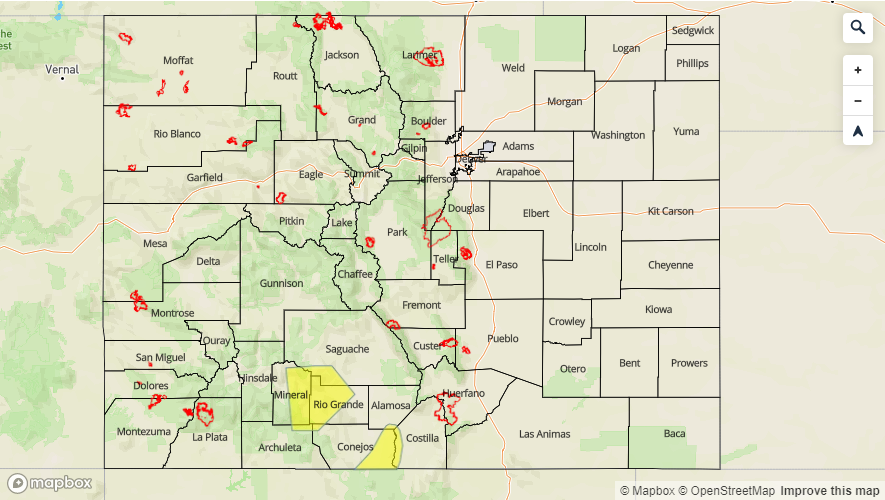
–A LOW flood threat is issued for Saguache Creek just west of Saguache through this afternoon
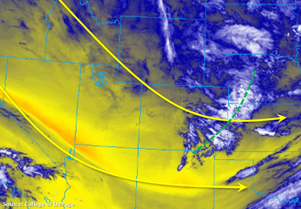
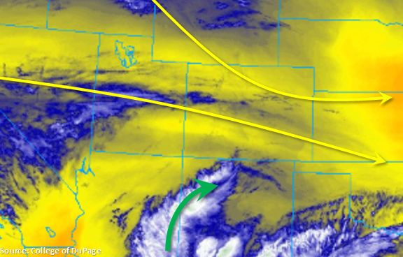
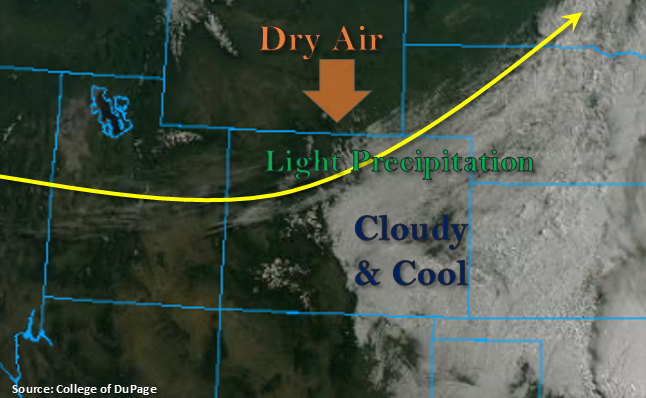
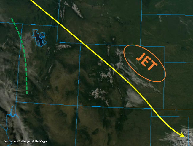
Beautiful start to the morning across the state with some mid-level clouds present over the Urban Corridor and Raton Ridge areas. Expecting those clouds to burn off quickly this morning with the increase in sunshine. Today, Colorado will once again be under the influence of northwesterly flow aloft. The jet is currently located over the Northeast Plains and is causing an increase in surface winds over the area (15-20 mph range). Forecasting this feature to push to the east by later this afternoon, which should reduce surface winds. Northerly surface winds this morning are expected to turn more easterly over the immediate adjacent plains by mid-afternoon. This will help kick off some storms over the higher terrains as well as some mid-level support moving in from the west. Dew points will be greatest over the southeast quadrant of the state (40°Fs). Therefore, expect afternoon storms over the southern Front Range and Southeast Mountains with cloud cover elsewhere due to the lower dew points. With the northwesterly flow aloft, storms will move into the adjacent plains and favor the higher elevation regions of the Palmer and Raton Ridges. Upper level dynamics may allow a weak thunderstorm or two to survive over the western Southeast Plains this evening, but activity should end by midnight.
Melting continues today, which will affect higher elevation rivers over southwest Colorado, so the Flood Watch for the San Juan Mountains and San Luis Valley continues. A Low flood threat (and Flood Warning) has been issued for Saguache Creek west of Saguache through this afternoon due to emergency management flooding reports from yesterday. A Low threat has also been issued for the Rio Grande near Del Norte due to the gage reporting Minor flooding and a Flood Warning issued by NWS this morning. See below for more details.
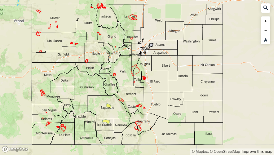
Today’s Flood Threat Map
For more information on today’s flood threat, see the map below. For Zone-Specific forecasts, scroll below the map.

Zone-Specific Forecasts:
Front Range, Southeast Mountains, Raton Ridge, Palmer Ridge, Urban Corridor, Northeast Plains, Southeast Plains:
Another day of average high temperatures is expected. Under northwest flow aloft, a dry air mass remains in place. Slightly better moisture will be over the southeast quadrant of the state (west portion). Therefore, the best chance for afternoon storms will be over the southern Front Range and Southeast Mountains. Max 1-hr rain rates should remain under 0.5 inches with most storms producing totals around 0.3 inches due to the high-bases. All storms that track over the Spring Creek burn area should be monitored closely, although 15-20 mph storm movement should limit the flood threat. Activity will likely spill into the adjacent plains over the Raton and Palmer Ridges with a couple of weak thunderstorms possible over the Southeast Plains through midnight.
Increased flows over the Arkansas west of Pueblo will also be monitored closely over the next week as a couple of gages remain in the Action stage. Not expecting any of these gages to reach the Minor flooding mark today, but Canon City could have some minor flooding issues by this weekend. The Arkansas gage near Avondale has gone back below Minor flood stage. Please tune into your local NWS office for the latest on flood warnings, advisories and statements and follow the daily FTB.
Primetime: 3PM to Midnight
Northern Mountains, Central Mountains, San Juan Mountains, Northwest Slope, Grand Valley, Southwest Slope, San Luis Valley:
The dry air mass remains over western Colorado before PW values start to increase tomorrow. So not forecasting rainfall again this afternoon with the exception of a brief shower over the eastern San Juan Mountains near the Continental Divide. There will be an increase in cloud from west to east with the approaching shortwave marked in the water vapor imagery this morning. Highs today will be similar to yesterday.
Melting of the high elevation snowpack will continue today and a Flood Watch continues for the San Juan Mountains and San Luis Valley. A Low flood threat (and Flood Warning) has been issued for Saguache Creek west of Saguache through this afternoon due to emergency management flooding reports from yesterday. A Low threat (and Flood Warning) has also been issued for the Rio Grande near Del Norte due to the gage reporting Minor Flooding. Areal Flood Advisories (as of 9AM this morning) are issued for the following: Tomichi Creek at Gunnison, Eagle River at Red Cliff, central Hinsdale County along Williams Creek, Colorado River near the CO/UT state line, Los Pinos River near Bayfield, San Juan River at Pagosa Springs, La Plata River at Hesperus, Mancos River in Montezuma County, Navajo River near Chromo, Animas River at Durango and the Gunnison River above Grand Junction. Please tune into your local NWS office for the latest on flood warnings, advisories and statements and follow the daily FTB.
Primetime: 4PM to 9PM