Issue Date: Tuesday, June 2, 2020
Issue Time: 10AM MDT
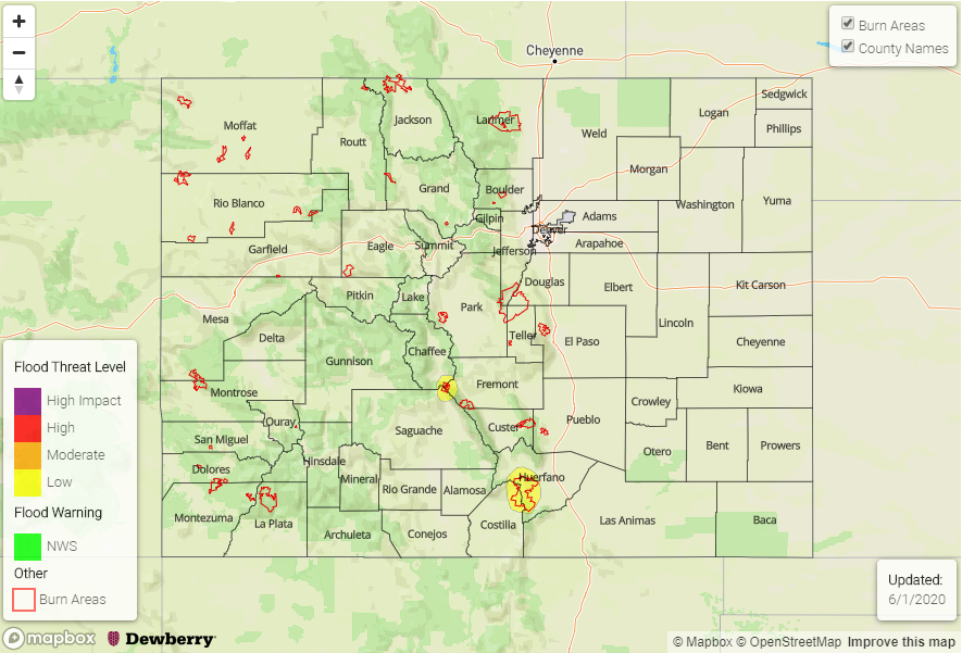
— A LOW flood threat has been issued for eastern parts of the Northeast Plains
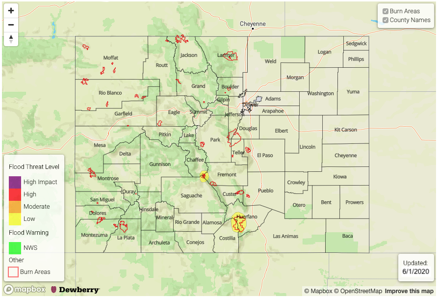
— A LOW flood threat has been issued for the Spring Creek burn scar in Huerfano and Castillo counties
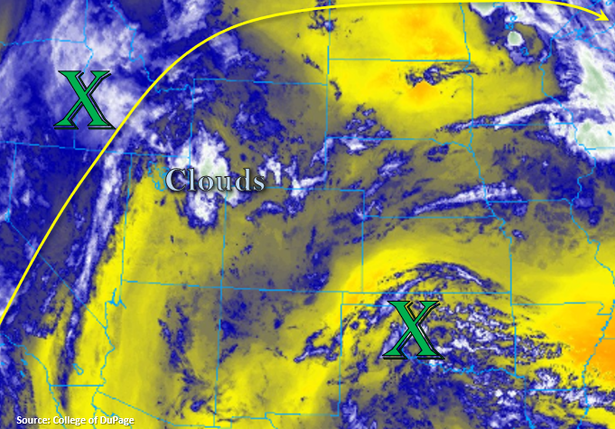
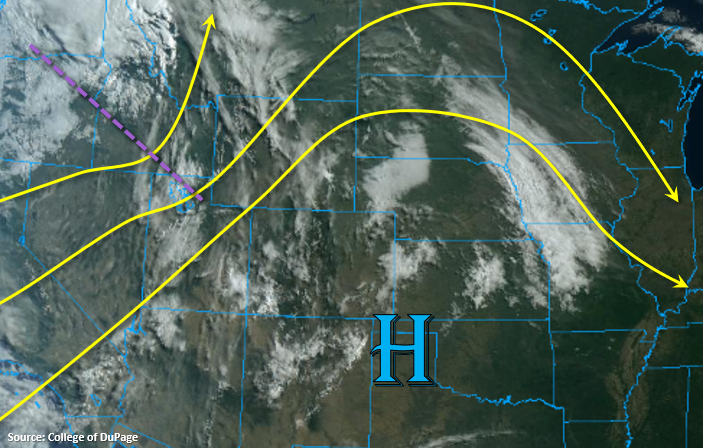
There are two factors at play that will guide heavy rainfall chances across Colorado over the next 24-hours, as can be seen in the visible satellite imagery below.
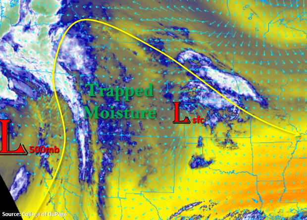
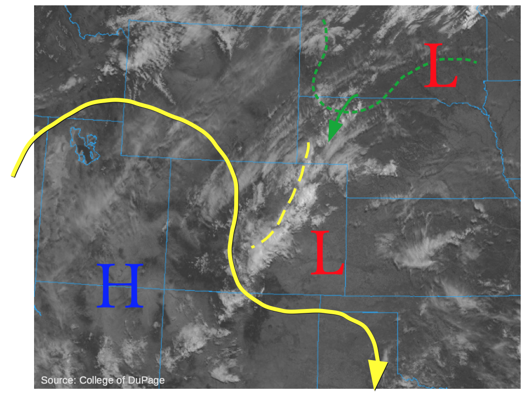
First, a rather unusual feature: a band of ongoing shower and weak embedded thunderstorms extending from the Northeast Plains southwestward into the Southeast Mountains and even spilling over into the San Luis Valley. The unusual part being the fact that this is occurring during the morning, implying some active atmospheric dynamics overhead. Loops of overnight satellite images suggests this is a mid-level disturbance that has been cut-off from the main flow, and will be a key feature in organizing this afternoon’s diurnally-enhanced shower and storm activity in southeast Colorado. This morning’s Grand Junction and Denver radiosonde’s showed a Precipitable Water (PW) of 0.48 and 0.65 inches, respectively. This is similar to yesterday. However, some subtle drying is expected across western and central Colorado today, as a small-scale ridge rebuilds over the Four Corners. Thus, expect less storm activity across these areas. East of the Continental Divide, an area of higher moisture was noted on the SPC Mesoanalysis with a bulge of PW exceeding 0.80 inches over the Southeast Plains. Overnight and morning high-resolution model guidance is having a difficult time capturing the small-scale moisture maximum and circulation with ongoing precipitation. Thus, precipitation probabilities and rain rates look too low over the Southeast Mountains and Raton Ridge this afternoon. However, the only area of concern looks to be the Spring Creek burn area, which has been highlighted with a Low flood threat today.
The second feature of note is a strong cool front located over the US Northern Plains, associated with an area of low pressure moving eastward today. Note the choice of the word “cool”, as for our state, this front is more noteworthy for its moisture boundary than its temperature gradient. The moisture boundary is expected to race into Colorado late this afternoon, setting the stage for some severe weather across the far eastern parts of the state. Heavy rainfall will be likely, but the only areas of concern look to be near the Kansas border. Guidance suggests PW will increase up to 1.2 inches, with CAPE up to 2,000 J/kg. Upper-level storm motion will be weak but strong N/NE low-level flow will be capable of producing enough shear for storm cell training. A 3-4 hour window of possibly very heavy rainfall warrants a Low flood threat for this small area.
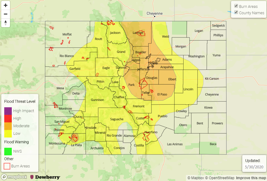
Today’s Flood Threat Map
For more information on today’s flood threat, see the map below. If there is a threat, hover over the threat areas for more details, and click on burn areas to learn more about them. For Zone-Specific forecasts, scroll below the threat map.
Zone-Specific Forecasts:
Southeast Plains, Palmer Ridge, Raton Ridge, Southeast Mountains, Southeast Plains:
Scattered showers and weak storms increasing in coverage and intensity this afternoon and evening, especially across southern areas. Max 1-hr rainfall up to 0.7 inches above 6,000 feet and 1.0 inch below 6,000 feet is possible this afternoon and evening. A Low flood threat has been issued for the Spring Creek fire burn for this afternoon and evening. The strongest storms will also be capable of gusty winds. Primetime is noon through 10PM.
Northeast Plains, Urban Corridor, Front Range:
Variable cloudiness early then isolated to scattered showers possible this afternoon mainly over the higher terrain. Max 1-hr rainfall up to 0.5 inches. Another wave of storm activity is likely with the arrival of a moisture surge after about 5PM. Max 1-hr rainfall up to 2.1 inches (far eastern areas) and 0.7 inches (western areas) are possible. The strongest storms will be capable of producing gusty winds and hail up to 1.5 inches. A Low flood threat has been posted for far eastern areas for flash flooding and street flooding. Primetime is 3PM through 11PM.
San Juan Mountains, Central Mountains, San Luis Valley:
Increasing clouds with isolated to scattered showers developing early this afternoon and into the evening. Max 1-hr rainfall up to 0.6 inches, mainly across eastern areas. Flooding is not expected today.
Northern Mountains, Northwest Slope, Grand Valley:
Mostly sunny and hot today with an isolated thunderstorm possible across southern and eastern areas. Max 1-hr rainfall up to 0.25 inches. Flooding is not expected today.