FTB 06-26-2020: Severe Storms and Heavy Rainfall Forecast for Eastern Colorado

Issue Date: Friday, June 26th, 2020
Issue Time: 9:35AM MDT

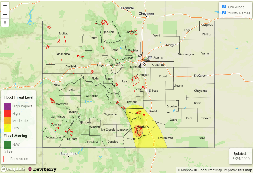
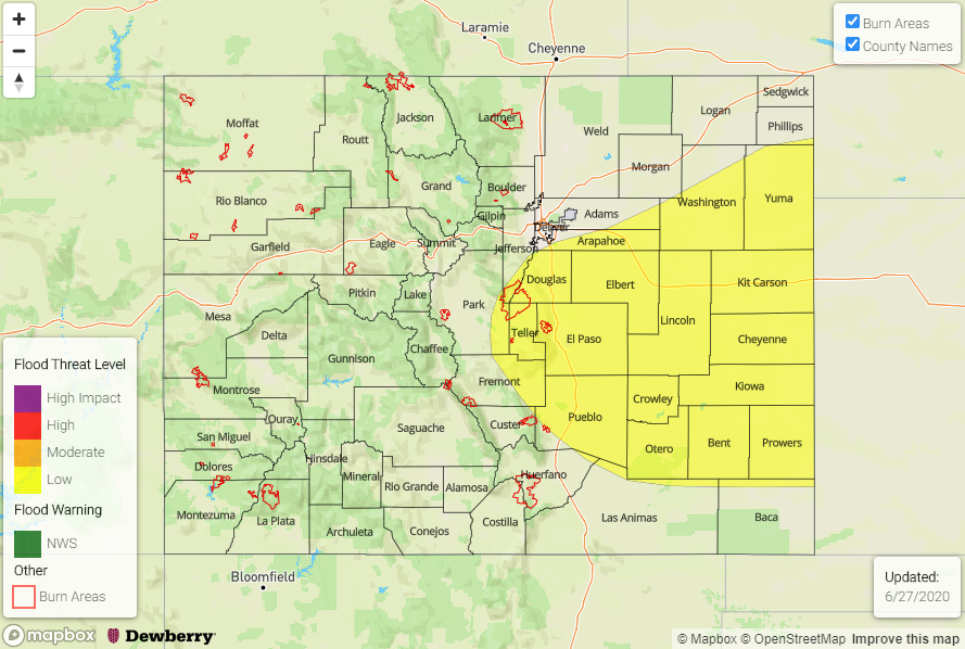
— A LOW flood threat has been issued for the Palmer Ridge and portions of the Urban Corridor, Northeast Plains, and Southeast Plains

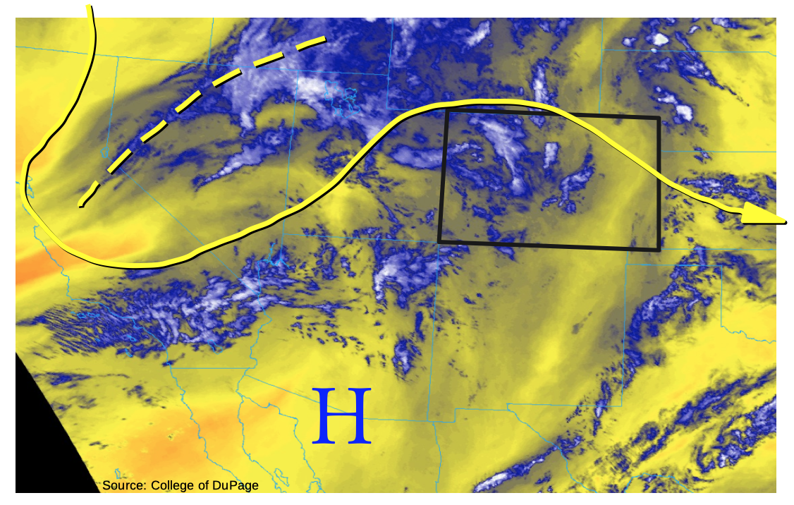
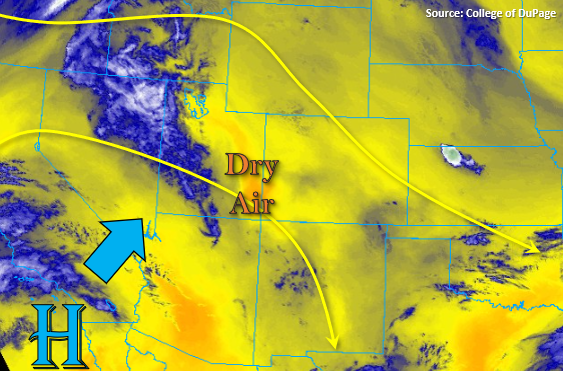
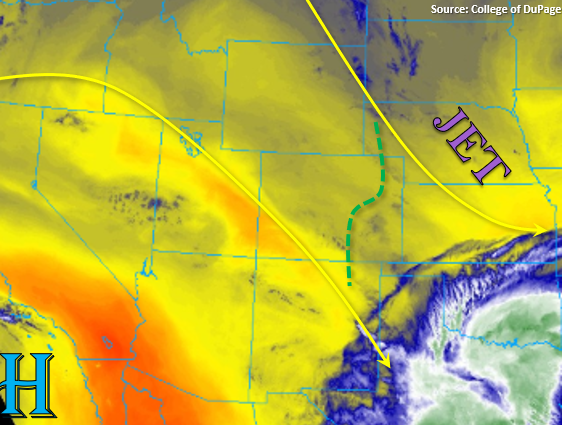
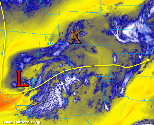
It’s going to be an active rainfall day for the state with severe weather likely over eastern Colorado late this afternoon and evening. For the synoptic set up, some mid-level energy has broken off from the main flow and is sitting over California. This will allow vorticity to move through the state and enhance lift (coverage and strength of storms), which can be seen in the water vapor imagery below (orange “X”). As for moisture, a cold front moved through eastern Colorado last night, so the low levels look pretty moist in this area. The dew point at DIA this morning was 53F, and PW was measured at 0.86 inches. Over Grand Junction, it’s a bit drier with dew points in the mid-40Fs, but PW was measured at 0.70 inches (above climatology). There also looks to be a little better moisture over the northwest corner of the state associated with a shortwave moving through the area, which will help spark scattered storms this afternoon and evening.

Moderate westerly flow aloft will likely mix out some of the surface moisture from west to east throughout the day, but widespread thunderstorm activity is still forecast. Storms over western Colorado will likely be confined to the higher terrains and favor the Central/Northern Mountains and Grand Valley/Northwest Slope where the shortwave moves through. Expecting storms to form over the eastern mountains by early afternoon as surface winds turn more easterly. Thunderstorms should push into the adjacent plains by 2 or 3PM. As they move east, outflow boundaries will likely trigger additional convection in a moisture rich environment, so storms will likely become a multi-cell cluster capable of producing large hail, local heavy rainfall, and damaging winds. A brief, weak tornado is also possible. Although storms will be moving at 15 to 20 mph (slightly to the southeast), they will still be capable of dropping local, heavy rainfall, so a Low flood threat has been issued. Thunderstorms should exit into Kansas and Nebraska just after midnight.

Today’s Flood Threat Map

For more information on today’s flood threat, see the map below. If there is a threat, hover over the threat areas for more details, and click on burn areas to learn more about them. For Zone-Specific forecasts, scroll below the threat map.

Zone-Specific Forecasts:

Front Range, Urban Corridor, Palmer Ridge, Southeast Plains, & Northeast Plains:

Storms will form a little sooner this afternoon and push into the adjacent plains by mid-afternoon. Activity will be widespread and more severe when compared to the last couple of days. Severe thunderstorms will be capable of producing strong winds, severe hail, and local heavy rainfall. As storms move east, the largest hazard becomes damaging wind, although some large hail will also still be possible. Cannot rule out a weak tornado as well. Max 1-hour rain rates up to 1.20 inches (west) will be possible (likely the Palmer Ridge) and up to 1.60 inches east. A Low flood threat has been issued for urban flooding (quick 0.50 inches in 30 min), field ponding, road flooding and local stream flooding. Storms will fully exit the state around midnight, so the flood threat ends a couple hours after sundown.

Primetime: 12:30PM to 12AM

Central Mountains, Northern Mountains, Northwest Slope, & Grand Valley:

Moisture has moved into the area from the passing shortwaves. Therefore, a little wetting rainfall is possible over the higher elevations in these regions. Scattered storms may produce max 1-hour rain rates up to 0.30 inches with slightly higher, localized totals in the Northern Mountains. Storms will also likely produce gusty outflow winds, so brief gusts up to 45 mph are also forecast. Flooding is not anticipated with the storms that form today.

Primetime: 1PM to 11PM

Southeast Mountains, San Juan Mountains, San Luis Valley, Southwest Slope & Raton Ridge:

It will be rather dry over these regions this afternoon with some scattered activity still forecast for the northern San Juan Mountains and Southeast Mountains. Additional storms may form along the elevated regions in Montrose and Mesa County as the shortwave moves through. Max 1-hour rain rates up to 0.15 inches will be possible. Today’s dry thunderstorms and gusty outflow winds will likely elevate the fire risk over these areas.

Primetime: 12:30PM to 9PM

FTB 06-25-2020: Continued Hot with More Storm Coverage, but No Flood Threat

Issue Date: Thursday, June 25, 2020
Issue Time: 9:45AM MDT

— Flooding is NOT expected today

This morning’s water vapor imagery, below, shows a rather disorganized mass of mainly mid-level moisture and some cloud cover across the Rocky Mountain states. As one may be able to guess, summer early morning cloud cover in Colorado often suggests the present of some atmospheric dynamics overhead. Such is the case today, as a stretched-out shortwave “digs” southeast into the Four Corner area. The feature is currently centered from western Montana southwestward into Nevada, and will slowly move into Colorado today and tomorrow. As has been the case many times in the past few weeks, limited moisture will prevent anything aside from brief heavy rainfall. However, storm coverage should increase, compared to yesterday.

This morning’s soundings showed a PW of 0.55 inches at Denver and 0.58 at Grand Junction. However, a very deep elevated mixed layer meant that most of this moisture was in the mid and upper-levels of the atmosphere. With a very steep lapse rate exceeding 9 Celsius/km between 500mb and 700mb at both sites, we can expect storms to be capable of producing gusty winds today (the motto of the 2020 summer so far!). Compared to yesterday, the storm-level steering flow will be a bit faster with a predominantly westerly direction. A deep-layer westerly flow tends to limit heavy rainfall east of the Continental Divide.

Overall, expect scattered showers and storms early this afternoon across most of the higher terrain, spreading eastward over the plains by mid-afternoon and into the evening. The vast majority of storms will be short-lived and produce 10-15 minutes of moderate to heavy rainfall over lucky locations. The only exception will be parts of the Northeast Plains, where a bit more moisture will support higher instability and the potential for severe thunderstorms. The main hazard is straight-line winds up to 65mph. A southerly to south-southeasterly component of the low-level flow will support heavier rainfall than areas farther west, but flooding is not expected today.

Today’s Flood Threat Map

For more information on today’s flood threat, see the map below. If there is a threat, hover over the threat areas for more details, and click on burn areas to learn more about them. For Zone-Specific forecasts, scroll below the threat map.

Zone-Specific Forecasts:

Northeast Plains, Front Range, Palmer Ridge, Urban Corridor, Southeast Plains, Raton Ridge, Southeast Mountains:

Partly cloudy early then scattered showers and thunderstorms developing by early afternoon over the higher terrain and spreading eastward. Continued very hot with temperatures up to 10F above normal, approaching 100F in the lowest elevations of the South Platte River and Arkansas River valleys. Max 1-hour rainfall up to 0.5 inches for western areas to 1.3 inches across far eastern areas by the Nebraska and Kansas borders. Severe storms are possible across the I-76 corridor mainly northeast of Fort Morgan, with the primary hazard being straight line wind gusts to 65 mph. A second round of storms could occur over far northeast areas around sunset as an expected convective complex moves southeastward out of Wyoming.

Flooding is not expected today, but some nuisance field ponding and localized urban flooding could occur for areas by the Kansas and Nebraska borders.

Central Mountains, Northwest Slope, Grand Valley, Northwest Slope, Southwest Slope, San Juan Mountains, San Luis Valley:

Partly cloudy early then isolated to scattered showers and thunderstorms developing by noon. Highest coverage over the higher terrain, though there will be overall more coverage than yesterday. Continued warm with high temperatures 5-8F above normal. Max 1-hr rainfall up to 0.4 inches. Gusty winds, up to 50mph, will be possible with the strongest storms during the late afternoon and early evening hours.

Flooding is not expected today.

FTB 06-24-2020: Garden Variety Storms Forecast for the Mountains and Eastern Plains

Issue Date: Wednesday, June 24th, 2020
Issue Time: 8:15AM MDT

— Flooding is NOT expected today

Rinse and repeat pattern today with a few minor differences in the details. While the High continues to produce northwest flow over the state, it will also move northeast into Arizona this afternoon. Additionally, the axis ridge to our north will be pushed slightly east as the next incoming system sets up to our west. Both of these will place a drier air mass over the state, which can be seen below in the water vapor imagery (more yellow and orange shades than blue). This drier air mass should also produce lower rain rates when compared to yesterday. Also similar to yesterday, there is no large visible shortwave moving through the flow aloft or jet stream overhead, which will translate to more garden variety and weak thunderstorms this afternoon and evening. Although storm movement will still be slow to the southeast and trailing storms may help increase local totals, flooding is not expected.

Today’s Flood Threat Map

For more information on today’s flood threat, see the map below. If there is a threat, hover over the threat areas for more details, and click on burn areas to learn more about them. For Zone-Specific forecasts, scroll below the threat map.

Zone-Specific Forecasts:

Southeast Mountains, Front Range, Urban Corridor, Southeast Plains, Northeast Plains, Palmer Ridge, & Raton Ridge:

Storms should initiate over the high terrains by early afternoon favoring the Front Range, western Palmer Ridge, and Southeast Mountains for development. Storm motion will once again be to the southeast, which will cause storms to spill into the adjacent plains by 3 or 4PM. Garden variety thunderstorms are forecast with gusty winds being the main threat under the stronger storms. Isolated max 1-hour rain rates up to 0.70 inches will be possible (west) and 0.40 inches (east). Slightly lower rain rates are anticipated over the Southeast Mountains and Palmer Ridge. Most activity will end around 11PM, and storms won’t likely make it east of Highway 71 (~104 degW). Flooding is not forecast today.

Primetime: 1PM to 12AM

Central Mountains, San Juan Mountains, Northern Mountains, Northwest Slope, Grand Valley, San Luis Valley, & Southwest Slope:

Scattered high-based storms will be possible over the Northern/Central Mountains near the Divide and over the south San Juan Mountains, but not much rainfall is forecast (up to 0.05 inches). Other than that, it should remain dry with temperatures a couple degrees warmer than yesterday with the ridge strengthening over the state. A few storms may track into the Southwest Slope from Utah, but only gusty winds are forecast as the storms begin to dissipate in the dry air mass.

FTB 06-23-2020: Slow Moving Storms Return the Flood Threat to the Southeast Mountains and Raton Ridge

Issue Date: Tuesday, June 23rd, 2020
Issue Time: 9:05AM MDT

— A MODERATE flood threat has been issued for the Spring Creek burn area

— A LOW flood threat has been issued for the Southeast Mountains and Raton Ridge

Similar set up to yesterday with the main difference being that jet is well to the northeast over Nebraska. The High pressure system is located off the Baja/California coast, and it will keep weak northwesterly flow aloft over the state. Taking a look at the low-level water vapor imagery below, there looks to be moisture over the majority of the state (blue shades) minus the dry southwest corner (orange/yellow shade). Moisture in the boundary layer may decrease a bit throughout the day, but overall decent moisture should remain east of the green dashed line below. With slow storm motion to the southeast, storms should be able to drop a little more rainfall today, and trailing storms will also help increase 24-hour totals. Additionally, without much upper level support and no shortwave insight upstream, storms should be on the weaker end today and will likely pulse in intensity. Still, a couple weak thunderstorms may pop up near the southern border with the main threats being small hail and brief, gusty winds.

Guidance is indicating decent moisture along and just west of the southern Southeast Mountains, and enhanced convergence along the Raton Ridge/Wet Mountains may allow max 1-hour rain rates to reach up to 1.1 inches. Thus, a Low flood threat has been issued for the area. There’s also a good chance that a storm may form or track over the Spring Creek burn area. With max 1-hour rain rates in that area up to 0.75 inches possible, a Moderate flood threat has been issued. Burn scar flood threats include flash flooding of local streams, mud flows and debris slides, so use caution near the area.

Today’s Flood Threat Map

For more information on today’s flood threat, see the map below. If there is a threat, hover over the threat areas for more details, and click on burn areas to learn more about them. For Zone-Specific forecasts, scroll below the threat map.

Zone-Specific Forecasts:

Southeast Mountains, Front Range, Palmer Ridge, & Raton Ridge:

Easterly and southeasterly flow of the surface winds will help initiate convection over the eastern mountains by early afternoon. Storms will be slow moving, which will allow rain totals to increase when compared to yesterday; however, storms will be small in area. With the weak steering flow, storms will barely make it into the Urban Corridor and will favor the elevated ridges as they make their way southeast. Max 1-hour rain rates up to 0.50 inches will be possible over the Front Range with very isolated totals just under 1 inch possible over the southern Palmer Ridge.

Rain rates will increase further south due to slightly higher lowl-level moisture, so rain rates up to 1.1 inches will be possible over the Palmer Ridge and Wet Mountains. Therefore, a Low flood threat has been issued. There is also a good probability that totals near the Spring Creek burn area will reach around 0.75 inches, so a Moderate flood threat has been issued. Field ponding, local stream flash flooding and mud flows/debris slides (burn area) will be possible this afternoon. Without any upper level support, storms should end a couple hours after sundown.

Primetime: 1PM to 10:30PM

Southeast Plains & Northeast Plains:

The Northeast Plains look to remain relatively dry this afternoon. There may be a weak storm that moves into Weld County that forms on the Cheyenne Ridge, but 1-hour rain rates will only reach about 0.50 inches. Further south over the eastern Palmer Ridge and Southeast Plains, coverage of storms looks a little better this afternoon when compared to yesterday. The severe threat is a little less, but small hail and wind gusts up to 45 mph may be possible under stronger thunderstorms that form. Isolated max 1-hour rain rates up to 1.25 inches will be possible.

Primetime: 1PM to 11PM

Central Mountains, San Juan Mountains, Northern Mountains, Northwest Slope, Grand Valley, San Luis Valley, & Southwest Slope:

It should be mostly dry again with highs similar to yesterday or a couple degrees warmer. A couple high-based showers may develop over the highest terrains of the San Juan, Northern, and Central Mountains near the Divide this afternoon. However, totals should remain under 0.10 inches. The best chance for weak rainfall will be over the eastern San Juan Mountains, and a weak storm may track into the southern San Luis Valley. Expect brief gusty winds as the storms evaporate off the high terrains. There may also be some light rainfall over the western facing Southeast Mountains, but totals should remain under 0.25 inches. Lastly, a Red Flag Warning has been issued for portions of the Southwest Slope. Even though there will be lighter surface winds under the building ridge, patchy 10 to 15 mph winds are still expected in a region with very dry fuels and low relative humidity, which would allow fires to spread quickly. Please tune into NWS Grand Junction for the latest on the fire weather.