SPM 09-08-2021: Record High Temperature Set in Alamosa

Issue Date: Wednesday, September 8th, 2021
Issue Time: 9:40 AM MDT

Summary:

We are definitely settled in under the high-pressure ridge to the west, with little change in the weather pattern from the day before. Northwest flow around the ridge has brought hot and dry air, along with plenty of wildfire smoke to Colorado. Not a drop of rainfall was reported across the state yesterday between both CoCoRaHS observers and NWS gages, thanks to the limited moisture and sinking air. The small area of what appears to be rain in the SPM below in the Northeast Plains is actually a radar artifact due to wind turbines.

The presence of smoke and other pollutants has drastically reduced air quality, and nearly all of Western and Northern Colorado, including the Urban Corridor, is under an air quality advisory. Meteorologist Lauren Whitney shared the following view from Lookout Mountain yesterday morning, with Downtown Denver completely hidden from view.

In addition to the smoke, yesterday was unseasonably hot for much of the state. Alamosa reached 87 degrees yesterday, breaking the day’s previous record high of 86 (which was set just last year). High temperatures, low humity, and gusty winds have been unhelpful for fire-fighting efforts within the well as well.

As expected, no flooding was reported on Tuesday.

Click Here For Map Overview

The map below shows radar-estimated, rainfall gage-adjusted Quantitative Precipitation Estimates (QPE) across Colorado. The map is updated daily during the operational season (May 1 – Sep 30) by 11AM. The following six layers are currently available: 24-hour, 48-hour and 72-hour total precipitation, as well as maximum 1-hour, 2-hour and 6-hour precipitation over the past 24 hour period (to estimate where flash flooding may have occurred). The accumulation ending time is 7AM of the date shown in the bottom right corner. Also shown optionally are vulnerable fire burn areas (post 2012), which are updated throughout the season to include new, vulnerable burn areas. The home button in the top left corner resets the map to the original zoom.

SPM 09-07-2021: Hot and Dry Labor Day

Issue Date: Tuesday, September 7th, 2021
Issue Time: 9:15 AM MDT

Summary:

Labor Day was hot across the state, and included the return of smoke and haze, especially along the Urban Corridor where smoke pollutants and late summer ozone combined to drastically reduce air quality. In terms of precipitation, another day of short-lived, afternoon isolated thunderstorms on the Raton Ridge and Southeast Plains at the New Mexico and Oklahoma borders – but again, most of the action (and moisture) stayed south. Precipitation totals were light, less than 0.25 inches.

While this year had a largely uneventful Labor Day and “unofficial” end of summer – this time last year Colorado was experiencing a rapid shift in conditions when record heat changed to record in cold in just a few days. Denver also had its earliest snow in over 20 years. The Boulder WFO shared the following information on twitter, including notable records broken one year ago:

No flooding was reported on Monday. For rainfall estimates in your area, check out the State Precipitation Map below.

Click Here For Map Overview

The map below shows radar-estimated, rainfall gage-adjusted Quantitative Precipitation Estimates (QPE) across Colorado. The map is updated daily during the operational season (May 1 – Sep 30) by 11AM. The following six layers are currently available: 24-hour, 48-hour and 72-hour total precipitation, as well as maximum 1-hour, 2-hour and 6-hour precipitation over the past 24 hour period (to estimate where flash flooding may have occurred). The accumulation ending time is 7AM of the date shown in the bottom right corner. Also shown optionally are vulnerable fire burn areas (post 2012), which are updated throughout the season to include new, vulnerable burn areas. The home button in the top left corner resets the map to the original zoom.

SPM 09-06-21: Clear Skies to End the Weekend

Issue Date: Monday, September 6th, 2021
Issue Time: 9:20 AM MDT

Summary:

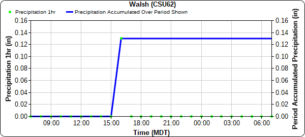
The weekend wrapped up as promised, with clear skies across Colorado thanks to the high-pressure ridge moving eastward. A couple isolated showers popped up in very Southeast Plains with storms inching up from New Mexico and the Oklahoma panhandle, however most of the action stayed south of the state line. A CoAgMet station in Walsh picked up a quick 0.13 inches in an hour, the only notable precipitation across Colorado yesterday.

No flooding was reported on Sunday. For rainfall estimates in your area, including antecedent rainfall, check out the State Precipitation Map below.

Click Here For Map Overview

The map below shows radar-estimated, rainfall gage-adjusted Quantitative Precipitation Estimates (QPE) across Colorado. The map is updated daily during the operational season (May 1 – Sep 30) by 11AM. The following six layers are currently available: 24-hour, 48-hour and 72-hour total precipitation, as well as maximum 1-hour, 2-hour and 6-hour precipitation over the past 24 hour period (to estimate where flash flooding may have occurred). The accumulation ending time is 7AM of the date shown in the bottom right corner. Also shown optionally are vulnerable fire burn areas (post 2012), which are updated throughout the season to include new, vulnerable burn areas. The home button in the top left corner resets the map to the original zoom.

SPM 09-05-2021: Much Drier Day with Isolated Thunderstorms in Eastern Colorado

Issue Date: Sunday, September 5th, 2021
Issue Time: 10:15 AM MDT

Summary:

Much drier air filled in across the state yesterday, especially compared to Friday, associated with the building ridge to the west. This acted to keep Western Colorado dry, however east of the divide there was still enough moisture for some early afternoon scattered convection to fire up along the Palmer Ridge, Southeast Mountains, Raton Ridge, and Southeast Plains. As afternoon turned to evening and overnight, isolated thunderstorms also occurred along portions of the Urban Corridor and Northeast Plains, in addition to continued storm coverage in the Palmer Ridge, Southeast Plains, and Raton Ridge.

A lone severe thunderstorm warning was issued yesterday evening for a storm in Huerfano County, north of Walsenburg – but the main threats were large hail and high winds, similar to most of the storms yesterday. Overall rainfall totals were fairly light, especially compared to the previous day, but those areas located under one of the isolated cells received some higher totals including:

  • Two CoCoRaHs observers in Southern Elbert County, Calhan and Raman with 0.95 and 0.52 inches, respectively (Elbert County, CoCoRaHS gauge)
  • Big Springs PWS in El Paso County with 0.98 inches
  • Fort Carson with 0.41 inches (USGS gauge)
  • Elizabeth with 0.28 inches (CoCoRaHS gauge)
  • Castle Rock with 0.20 inches (MHFD gauge)

No flooding was reported on Saturday. For rainfall estimates in your area, check out the State Precipitation Map below.

Click Here For Map Overview

The map below shows radar-estimated, rainfall gage-adjusted Quantitative Precipitation Estimates (QPE) across Colorado. The map is updated daily during the operational season (May 1 – Sep 30) by 11AM. The following six layers are currently available: 24-hour, 48-hour and 72-hour total precipitation, as well as maximum 1-hour, 2-hour and 6-hour precipitation over the past 24 hour period (to estimate where flash flooding may have occurred). The accumulation ending time is 7AM of the date shown in the bottom right corner. Also shown optionally are vulnerable fire burn areas (post 2012), which are updated throughout the season to include new, vulnerable burn areas. The home button in the top left corner resets the map to the original zoom.