STP 05-06-2015: Rainy Day For Most, But Flooding Avoided

Issue Date: May 6th, 2015
Issue Time: 9:00 AM MDT

Summary:

On average, May is the wettest month of the year for many weather observing stations east of the Continental Divide and yesterday, those averages did not lie. Most of Colorado was blanketed with a thick cloud deck by sunrise that persisted throughout the day. As Colorado typically receives around 240 sunny days per year, the recent streak of consecutive rainy days has left many residents wondering if they are in the right place! But, as our Flood Threat Outlook shows, the rainy days will likely keep on coming right through the weekend. Stay tuned for an update on the long-range forecast tomorrow by 3PM.

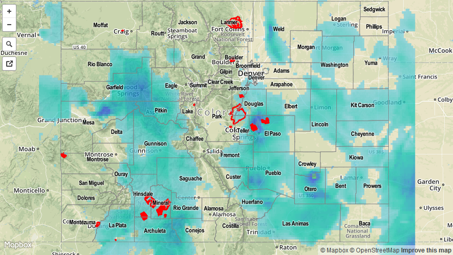
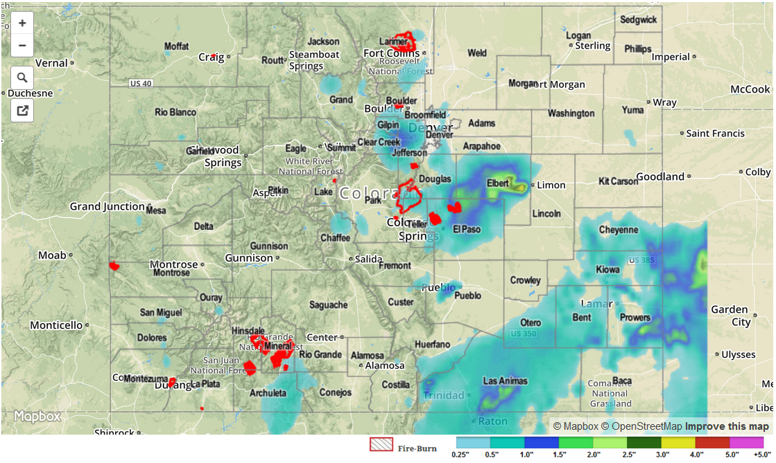
Back to yesterday’s weather, many locations across the state received over an inch of rain. As noted by CoCoRaHS observers, the following counties experienced 1 inch or more rainfall: Garfield, El Paso, Weld, Adams, Denver, Routt, Eagle, Cheyenne and Fremont. However, hourly rain amounts were in the 0.2-0.5 inch intensity, preventing any flood threat. Nonetheless, many urban areas saw minor ponding of water in the streets.

No flooding was reported yesterday.

Please see the map below for estimated rain totals in your area.

05072015_MapImage
Storm Total Precip Legend

STP 05-05-2015: Showers and Thunderstorms Set Up Shop in Colorado

Issue Date: Tuesday, May 5th, 2015
Issue Time: 9:15 AM MDT

Summary:

A slow moving cut-off upper-level system provided ample support for continuous shower and thunderstorm activity covering much of the state. Fortunately, the rain rates were generally light enough to avoid serious flooding concerns. An Urban Drainage ALERT station measured a rain rate of 1.3 inches per hour, while similar rain rates, perhaps approaching 1.5 inches an hour, were observed over the Palmer Ridge in eastern Elbert county.

The highest daily rain totals occurred over the Palmer Ridge near in El Paso and Elbert counties with several CoCoRaHS observers noting over 2 inches of rain. Flood advisories and warnings were issued in the later afternoon and evening hours as runoff began to cause minor flooding issues. West of the Continental Divide, rainfall amounts of 0.5-0.75 inches were noted across many areas.

One official flood report was received 9 miles west-southwest of Limon, with road flooding being observed on County Road 86.

Please see the map below for estimated rain totals in your area.

STP_snapshot_20150505

STP 05-04-2015: Scattered Showers and Thunderstorms Brought Rain to a Majority of the State

Issue Date: Monday, May 4th, 2015
Issue Time: 9:00 AM MDT

Summary:

As moisture climbed throughout the afternoon and into the early morning hours, so did the amount of showers and thunderstorms across the state. While most locations received only a light shower (less than 0.1”), a variety of places along the Front Range, Urban Corridor, Palmer Ridge, Northeast Plains, and Southeast Plains received north of 0.5 inches of rain. A few stronger thunderstorms produced moderate-to-heavy rain; in fact, rain rates from a storm near Berthoud yesterday afternoon were in the 1.0-1.5 inches/hour range, as estimated by the radar. Showers and thunderstorms lingered into this morning, with a few still currently ongoing. The wet period will continue today, so be sure to check in on the Flood Threat Bulletin forecast, scheduled to post by 11 AM.

No flash flooding occurred yesterday.

STP 05-03-2015: Mother Nature Got the Most Out of the Available Moisture

Issue Date: Sunday, May 3rd, 2015
Issue Time: 9:00 AM MDT

Summary:

Moisture was only 60% of what it was on Friday, yet Mother Nature still did the best she could to ring out the majority. Storms were more isolated than the previous day, and intensity was down overall, owing to the lessened moisture; however, a few strong-to-severe storms were able to develop over the plains regions. Rainfall was generally light at the surface, as most of the moisture was confined in the mid-levels. Most rainfall reports are below 0.25 inches, with a few coming in greater than that over the Northeast and Southeast Plains.

Only one severe report was received; 60 mph thunderstorm wind gust was reported 4 miles E of Wiley in Prowers County.

No flash flooding occurred yesterday.

20150504_STPImage
Storm Total Precip Legend