STP 05-30-2015: Storms Coverage Decreased, But Still Several Heavy Rain Makers

Issue Date: Saturday, May 30th, 2015
Issue Time: 9:00 AM MDT

Summary:

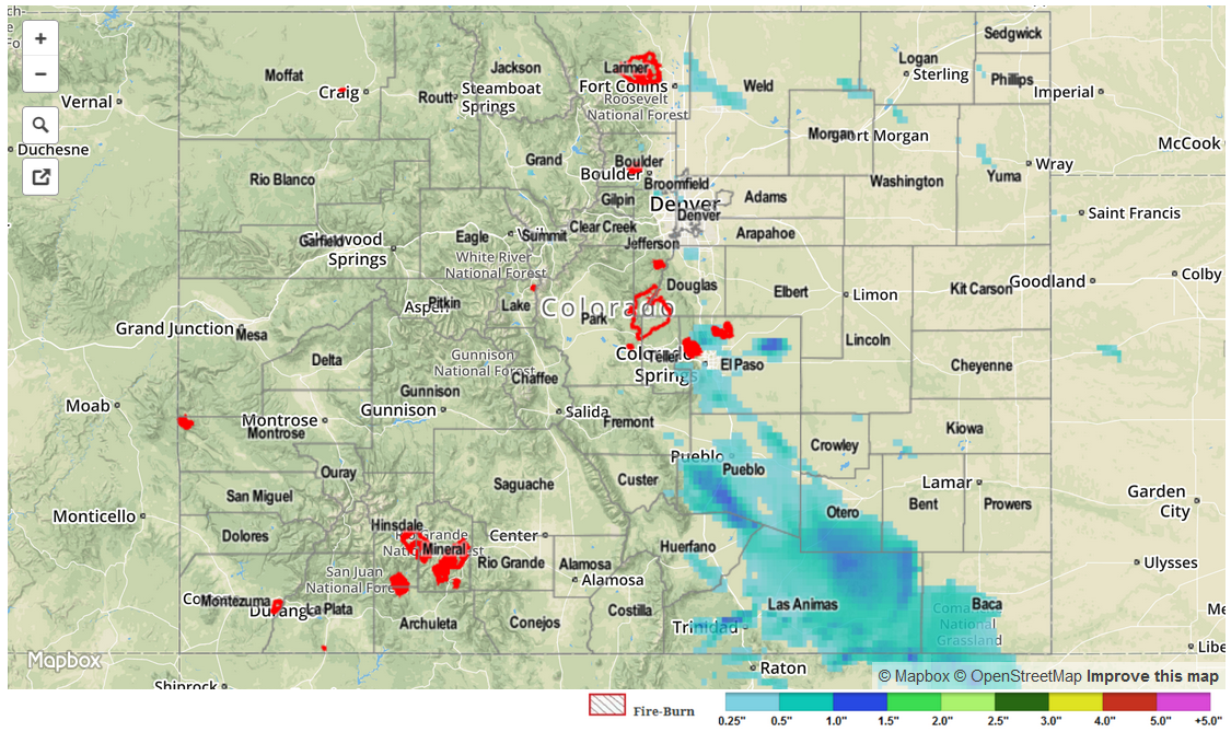
The tail end of a multi-day disturbance brought scattered showers and thunderstorms across Colorado on Friday. While most storms looked more intimidating than they actually were, several storms over the Palmer Ridge and Southeast Plains produced very heavy rainfall. Fortunately the rainfall was brief and did not cause any flooding problems. For example, an observer in El Paso county noted 0.25 inches fell in 6 minutes (the equivalent of 2.50 inches per hour). These storms were also responsible for several hail reports, up to 1 inch in diameter. In all, about a handful of 1+ inch rainfall amounts were noted across El Paso and Pueblo counties. Meanwhile, several rounds of mostly weak storms amounted to 0.5 to 0.9 inches of rainfall across Weld and Larimer counties. Aside from this action, most everyone else experienced less than 0.5 inches of rainfall.

The South Platte River continued to subside below Minor flood stage. However, parts of the Arkansas River remained in Minor flood stage, receiving a short-term boost from yesterday’s rainfall in the upstream regions.

Snowmelt was ongoing with the warm conditions. Interestingly, though, an inspection of SNOTEL data across each of the eight major drainage basins revealed that seven of the eight had an above average snowpack for this time of year. The one exception was the Yampa / White River basin, but even there conditions were very close to what is expected for late May. This is certainly quite a welcome change from a month ago when the western parts of the state were experience a serious snowpack “drought”.

No flash flooding was reported yesterday. Please check the map below for estimated rainfall in your area.

STP_snapshot_20150530

STP 05-29-2015: Scattered Thunderstorms Rumbled Across Colorado

Issue Date: Friday, May 29th, 2015
Issue Time: 9:00 AM MDT

Summary:

An upper-level disturbance aided thunderstorm development yesterday, producing scattered thunderstorms statewide. Moisture near the surface was lessened compared to the previous day for most locations, resulting in less heavy rain at the surface and no flash flooding issues. The Northeast Plains, Southeast Plains, and Palmer Ridge retained better low-level moisture, and provided quite the show in the way of severe thunderstorms. The following are severe storm reports from the National Weather Service:

1.5 inch hail: NNW of Iliff (Logan County), Walsh (Baca County)
1.0 inch hail: 1 mile N of Elizabeth (Elbert County), 6 miles E of Denver (Arapahoe County)
Tornado: 15 miles S of Vilas (Baca County), 6 miles S Kim (Las Animas County)
Funnel Cloud: 8 miles SE of Kim (Las Animas County)

As far as rainfall totals are concerned, most locations received less than 0.25 inches of rainfall. CoCoRaHS observations from the following counties are yesterday’s “big winners:”

Las Animas: 1.68 inches
Baca: 0.78 inches
Yuma: 0.77 inches
Kit Carson: 0.60 inches
Cheyenne: 0.55 inches

No flash flooding was reported.

STP_snapshot_20150530

STP 05-28-2015: Storms Battle Dry Air To Stay Alive; Snow Melt Begins In Earnest

Issue Date: May 28th, 2015
Issue Time: 8:55AM MDT

Summary:

Thundershowers had a tough time battling the drier upper-level air in place on Wednesday. This is quite a contrast from the past two to three weeks where the upper-level atmosphere was very humid and conducive to storm formation. Regardless, quite a number of mostly weak thunderstorms formed across the state by early afternoon. Storm motion was enough to keep one hour rain rates in the 0.2 to 0.5 inch range. Overall, the highest 24-hour rain total came in from Trinidad in Las Animas county at 1.23 inches.

The strongest cells of the day were found along the Kansas border, where moisture and instability were in more abundance. There, hail up to 2 inches was observed, along with a tornado sighting in Yuma.

As can be expected this time of year, the warmer temperatures have begun to work on the high elevation snowpack. An inspection of several SNOTEL sites reveals that up to 2 inches of snow water equivalent melted or sublimated (from snow straight to water vapor) on Wednesday alone. For many locations, this represents 10% or more of the entire snowpack. Interestingly, this shows that while snow takes many months to accumulate, it can be gone in a matter of a week or two given warm weather.

No flash flooding was reported yesterday. However, parts of the Arkansas and South Platte Rivers continued to be in minor flood stage.

Please check the map below for estimated rainfall in your area. Note that the rainfall in Yuma county may be overestimated due to hail.

05282015_STPImage
Storm Total Precip Legend

STP 05-27-2015: How Many Different Ways Can One Say “Scattered Showers and Thunderstorms?”

Issue Date: Wednesday, May 27th, 2015
Issue Time: 9:00 AM MDT

Summary:

FLOOD WARNINGS CONTINUE FOR PORTIONS OF THE CACHE LA POUDRE, SOUTH PLATTE, AND ARKANSAS RIVERS.

Weak ridging moved overhead yesterday and led to a slight downtick in the number of showers and thunderstorms across the state. However, an embedded weak disturbance still provided a trigger mechanism for scattered storms to develop. Moisture on Tuesday was up a bit from Monday, so a few storms produced heavier rain. A local storm report from 4 miles NNE of Colorado Springs observed 0.5 inches of rainfall in 10 minutes, equal to a 1-hour rain rate of 3 inches/hour! Storm motions kept flash flooding from being realized, so that is a positive note. Rainfall totals from CoCoRaHS observers show that most locations that received rain reported less than 0.25 inches, but the big winners were:

El Paso County: 0.63 inches
Elbert County: 0.61 inches
Otero County: 0.59 inches
Park County: 0.59 inches
Douglas County: 0.56 inches
Kiowa County: 0.50 inches

No flash flooding was reported yesterday. Be sure to check out the radar-estimated rainfall map below.

STP_snapshot_20150527