STP 07-01-2015: June Ended Much Differently Than It Started

Issue Date: 7/1/2015
Issue Time: 9:00AM

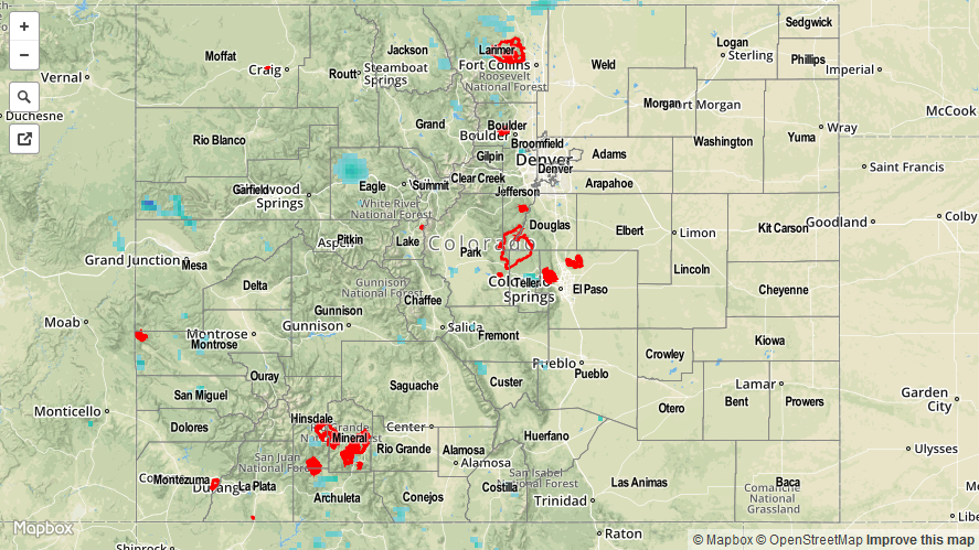
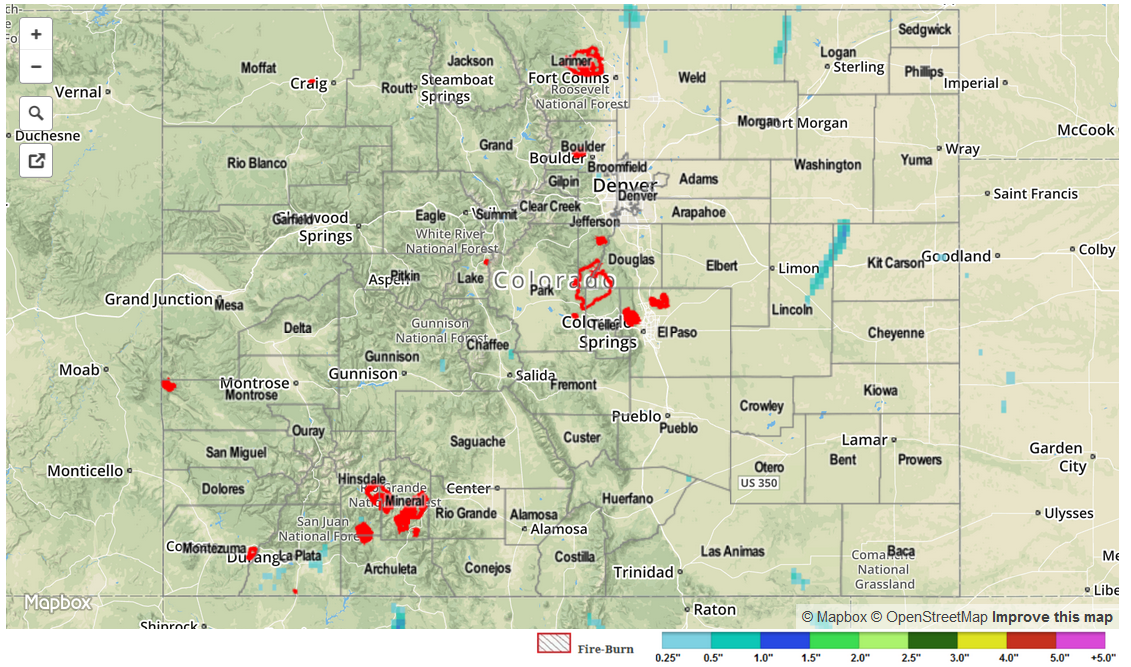
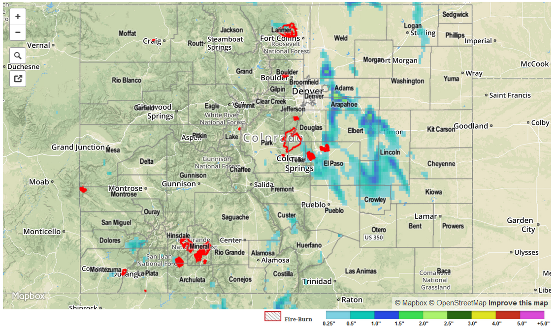
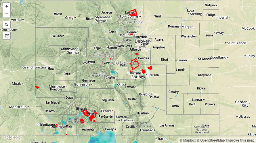
With ample support from a stout upper-level ridge, hot and mostly dry conditions prevailed across a majority of Colorado to end June. Isolated to scattered thunderstorms did form mainly across the higher terrain by early afternoon. However, the highest observed rainfall totals were only in the 0.5 to 0.6 inch rain, observed in Delta, Boulder and Larimer. Almost everyone else who was fortunate enough to have a thunderstorm move overhead experienced only some sprinkles with an appetizer of gusty winds. As a bit of a surprise, though, a rogue thunderstorm managed to pop up over Park and Teller counties in the early evening hours. Though the storm only lived for 30-40 minutes, it managed to drop 1.75 inch hail. Given the very marginal conditions for storm formation, we can only say that the Colorado atmosphere certainly knows how to get the most bang for its buck.

07012015_STPImage
Storm Total Precip Legend

STP 06-30-2015: Very Limited Storm Coverage

Issue Date: 6/30/2015
Issue Time: 9:00AM

Drying from above was a formidable obstacle for thunderstorm development on Monday. Storms that were able to form looked very impressive for one or two radar scans (radar scans are about 6 minutes apart), before their dry downdrafts evaporated the storm structure from within. Only limited rainfall actually made it to the ground. The highest official 24-hour rainfall totals came from the San Juan region with a few reports around 0.25 inches. Otherwise, our radar estimated rainfall map, below, shows one storm in eastern Lincoln and western Kit Carson counties that may have delivered over 0.5 inches to mainly rural areas.

Switching topics a bit, in all of Colorado only one stream flow gage officially remains in Minor flood stage: the Arkansas River at Avondale (just downstream of Pueblo). Flows jumped up just a bit overnight due to releases from the nearly full Pueblo Reservoir. All in all, it seems we can finally close the book on the impressive 2015 snow melt season here in Colorado.

STP_snapshot_20150630

STP 06-29-2015: Isolated-to-Scattered Thunderstorms Dotted the High Country and Adjacent Low Elevations

Issue Date: Monday, June 29th, 2015
Issue Time: 9:00 AM MDT

Summary:

Yesterday started out fairly benign, with isolated-to-scattered showers/weak thunderstorms dotting the High Country. As the day progressed into the afternoon hours, intensity began to pick up on a few storms, bringing stronger outflow winds, small hail, and brief heavy rain. During the evening hours, activity increased across the adjacent low elevations of the Urban Corridor, Northeast Plains and Palmer Ridge, with a few storms reaching severe thresholds. Severe storm reports include:

1.5 inch hail: 3 miles S of Country Gardens (Arapahoe)
1.25 inch hail: Briggsdale (Weld), 6 miles NE of Colorado Springs (El Paso), 5 miles SSW of Black Forest (El Paso)
1.0 inch hail: 8 miles SE of Arapahoe Park (Elbert), 1 mile N of Black Forest (El Paso), 3 miles NE of Black Forest (El Paso), 5 miles NNW of Peterson AFB (El Paso), 4 miles NW of Peterson AFB (El Paso), 4 miles SSW of Black Forest (El Paso), 4 miles WNW of Peyton (El Paso), 8 miles NE of Black Forest (El Paso)

No flash flooding was reported.

STP_snapshot_20150629

STP 06-28-2015: Warmer and Drier East, Isolated-to-Scattered Showers and Thunderstorms Over the High Country

Issue Date: Sunday, June 28th, 2015
Issue Time: 9:00 AM MDT

Summary:

It would be hard to point to a better Saturday than what Colorado experienced yesterday. Due to upper-level high pressure continuing to build across the western US, isolated-to-scattered showers and thunderstorms were confined to the higher terrain. Most storms produced gusty outflow winds, lightning, and brief light-to-moderate rain. Hail observations greater than 0.5 inch were reported in Saguache (0.88 inch) and La Plata (0.70 inch) Counties; no other reports were made yesterday. Abundant sunshine was the main story yesterday for the majority of Colorado’s population – a great way to spend a late-June weekend.

No other flash flooding was reported yesterday.

20150628_STPImage
Storm Total Precip Legend