STP 05-01-2016: Spring Storm Welcomes Back the STP Product

Issue Date: Sunday, May 1st, 2016
Issue Time: 9:00 AM MDT

Summary:

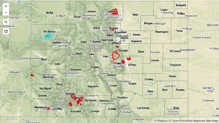
Yesterday’s temperatures were well below average for April 30, but did not come without a silver-lining. The late-April spring storm brought good moisture to Colorado, in both rain and snow form. The Northwest Slope and Grand Valley regions were mostly left out on the precipitation, while the Front Range, Urban Corridor, and Palmer Ridge regions experienced the most. According to CoCoRaHS observers, here are the big winners for…

Rain/ Snow Liquid Equivalent reports:
Douglas County: 0.64 inches
Larimer County: 0.55 inches
Chaffee County: 0.52 inches
Jefferson County: 0.50 inches
Washington County: 0.45 inches
Weld County: 0.41 inches

Snow reports:
Larimer County: 7.0 inches
Jefferson County: 5.0 inches
Chaffee County: 5.0 inches
Douglas County: 4.4 inches

No flash flooding occurred yesterday. Please see the STP map below for a look at precipitation totals from the last 24 hours.

20160501_STPImage
Storm Total Precip Legend

STP 09-30-2015: Moisture and a Corridor of Instability Produced “End of FTB Season” Fireworks

Issue Date: Wednesday, September 30th, 2015
Issue Time: 9:00 AM MDT

Summary:

In the wake of Monday’s cool front, moisture was pooled across eastern Colorado, from the plains and back into the Front Range/Southeast Mountains. After the morning clouds cleared along and near the higher terrain, daytime heating was able to develop a corridor of instability along the Front Range, Southeast Mountains, and Urban Corridor. These two ingredients, plus a little help from a weak upper-level disturbance, promoted the development of isolated thunderstorms (a couple were severe). Severe storm reports from the Boulder and Pueblo National Weather Service offices are as follows:

1.0 inch hail: 1 mile W of Centennial (Arapahoe), 1 mile W of Lakewood (Jefferson), 9 miles N of Golden (Jefferson), 1 mile ENE of Florence (Fremont)
1.25 inch hail: 1 mile ENE of Highlands Ranch (Douglas)
1.50 inch hail: 2 miles WNW of Lakewood (Jefferson)

No flash flooding was reported/observed yesterday. Please see the STP map below for a look at precipitation totals from the last 24 hours.


Storm Total Precip Legend

STP 09-29-2015: Welcomed Rain Re-Appeared Across Colorado

Issue Date: Tuesday, September 29th, 2015
Issue Time: 9:00 AM MDT

Summary:

Behind the front that passed through eastern Colorado yesterday existed a cooler, moister air mass, as upslope flow transported moisture into the region. At the mid- and upper-levels, moisture streamed in steadily from the west. Together, the two moisture sources pushed IPW values above average for the date, between 0.8 and 1.0 inches at the four normal reporting stations (Grand Junction, Pueblo, Shriever AFB, and Boulder). Sprinkle in a shortwave and marginal instability, and we had a recipe for isolated-to-scattered showers and weak thunderstorms, with a few ongoing at this time.

Rain rates were not particularly impressive, so no flash flooding was reported/observed yesterday. Please see the STP map below for a look at precipitation totals from the last 24 hours.

20150929_STPImage
Storm Total Precip Legend

STP 09-28-2015: Sunny and Dry with Near-Perfect Conditions to Catch the Lunar Eclipse

Issue Date: Monday, September 28th, 2015
Issue Time: 9:00 AM MDT

Summary:

Another day of sunshine and warm temperatures graced Colorado, allowing for a great end to the weekend. No precipitation fell anywhere across the state, and only a few mid- and high-level clouds were noted. If you were able to get outside between approximately 7 and 9 PM MDT last night, you were treated to quite the lunar show, as mostly clear skies provided a near-perfect look at the night sky. If you were unable to get outside and enjoy the show in real-time, take some time today to look up pictures from your favorite news source.

No flash flooding was reported yesterday.

20150928_STPImage
Storm Total Precip Legend