STP 06-18-2016: A Few Storms In the Far East, Otherwise Continued Hot and Dry

Issue Date: Saturday, June 18th, 2016
Issue Time: 8:55AM MDT

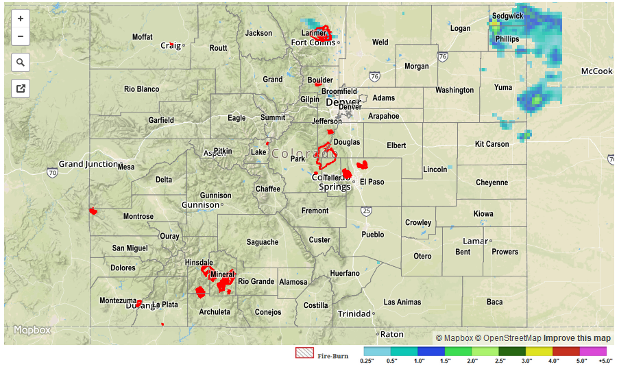
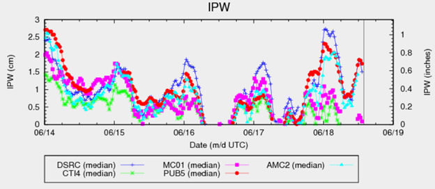
An impressive run-up in atmospheric moisture occurred on Friday as a cool front entered Colorado from the north and east. The chart below shows that Integrated Precipitable Water (IPW) went from less than 0.2 inches to about 1.0 in a matter of 8-12 hours at the Boulder site (blue line). However, due to overhead ridge, storms were generally limited to the far eastern part of the state. Up to 1.6 inches of rainfall fell in isolated locations in Yuma, Sedgwick and Phillips counties. At about the same time, upslope flow created a few weak storms along the Front Range with up to 0.5 inches of rainfall falling in Larimer and Boulder counties.

ipw

Elsewhere, it was hot and dry on Friday. As of this morning, two confirmed fires have been reported in Colorado. A fire in Las Animas County was 5% contained as of yesterday. A 30-acre fire is ongoing in La Plate County (#217fire on Twitter). Flooding was not observed on Friday.

For yesterday’s rainfall estimates, check out our Storm Total Precipitation map below.

STP_20160618

STP 06-17-2016: Hot and Dry Statewide

Issue Date: Friday, May 17th, 2016
Issue Time: 9:02AM MDT

The veteran ridge continued its grasp across Colorado on Thursday with hardly a cloud seen across the state. With strong subsidence in the mid-levels and ample sunshine, the atmosphere was quick to warm. Afternoon high temperatures near 90 F were common in the 5,000-6,000 feet elevations. In the lower elevations, a few locations such as Lamar saw afternoon temperatures of 100 – 105F along with relative humidity in the 10-15% range. At La Veta Pass (elev. 10,200 feet), high temperatures reached the mid 50s F.

The long duration of the ridge has sparked numerous wildfires across the southwest U.S. Fortunately, these have stayed out of Colorado thus far. However, New Mexico has not been as lucky with 2 fires now exceeding 10,000 acres and not much immediate hope for containment.

Snowpack has rapidly receded with the transition to summer. Only 3 SNOTEL sites across the state are showing remaining snow this morning. The highest value is Tower (North Platte River basin) with an impressive 16.5 inches of snow water equivalent left, right on par with average.

Flooding was not observed on Thursday.

STP_20160617

STP 06-16-2016: Dry and Hot with Plenty of Sunshine

Issue Date: Thursday, June 16th, 2016
Issue Time: 9:00 AM MDT

Summary:

Today’s Storm Total Precipitation discussion is going to be short and sweet, thanks to the upper-level ridging building across the central US. Dry and hot air continued to be transported in from the south-southwest, mixing out any remaining residual moisture. Due to this, it was hard to even find clouds in the sky yesterday. Quite the drastic change from just a couple days ago.

No flash flooding occurred yesterday.

STP_20160616

STP 06-15-2016: Abundant Sunshine and Dry

Issue Date: Wednesday, June 15th, 2016
Issue Time: 9:00 AM MDT

Summary:

High pressure expanded over the state yesterday, warming temperatures and opening skies to abundant sunshine. Moisture mixed out fairly quickly as drier air was transported in from the west-southwest, so even terrain-induced clouds were hard to find. Even so, sparse clouds over the higher terrain were noted, accompanied by a few patches of virga. Overnight, skies were clear and temperatures stepped down to seasonably cool readings.

No flash flooding occurred yesterday.

20160615_STPImage
Storm Total Precip Legend