SPM 07-31-2017: Repeat of Widespread Rainfall

Issue Date: Monday, July 31, 2017
Issue Time: 10:20AM MDT

Summary:

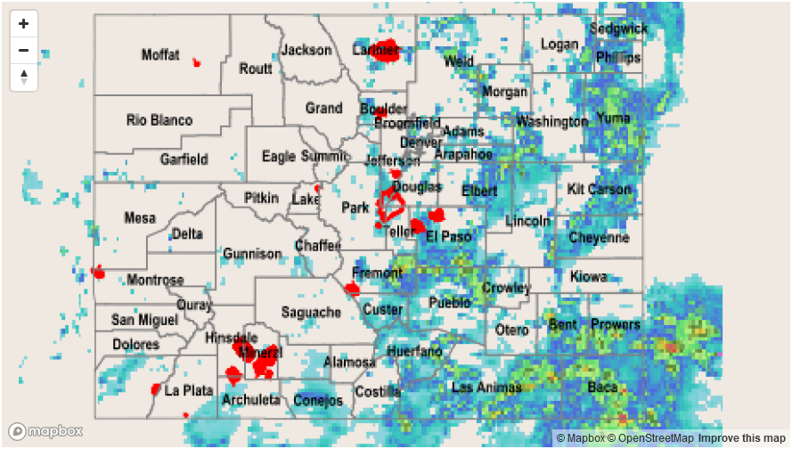
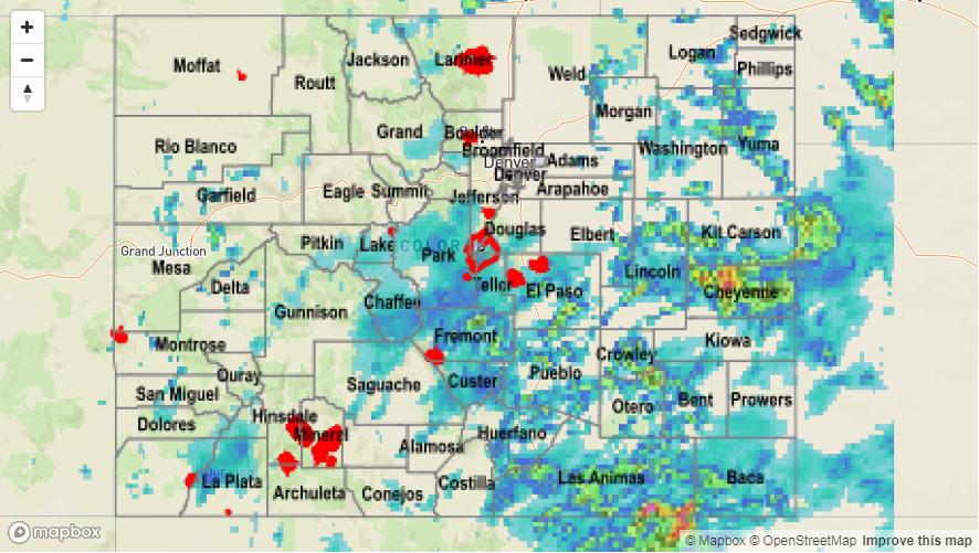
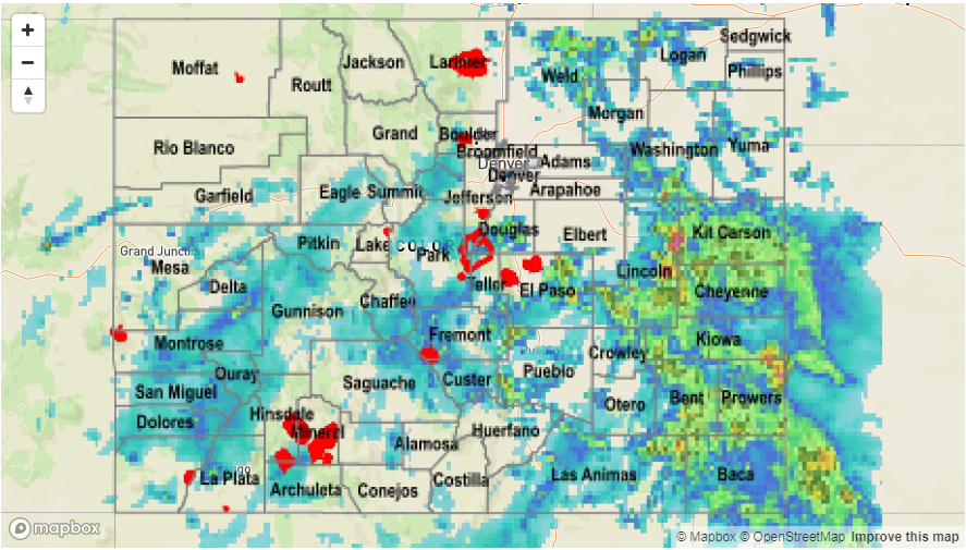
Ongoing convection continued yesterday across the mountains and eastern plains. The San Juan Mountains had yet another consecutive day of rainfall and even Alamosa had some rain (0.42 inches). This is second rainiest July for Alamosa on record. Over the Front Range and Southeast Mountains, storms favored the areas that received more diurnal heating and had extra lift from elevated terrain. In the early evening, storms over the panhandle of Nebraska moved through the Northeast Plains and eventually merged along the CO, NE, KS border. Showers over the mountains quickly subsided near sunset and the threat over the plains ended by about midnight, although some showers lingered through about 2AM.

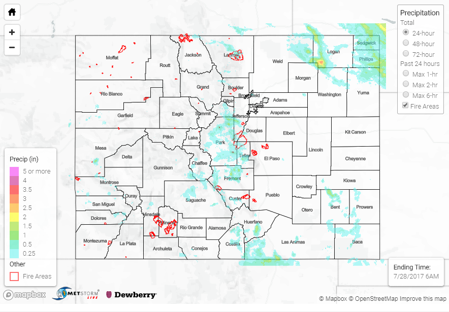
Over the San Juan Mountains, CoCoRaHS stations recorded around 0.5 inches. Radar estimates for this area were 1.1 inches. Over the Southeast Mountains, a CoCoRaHS station in Huerfano County (Walsenburg) recorded 2.33 inches. 2.28 inches of that total fell in 45 minutes. A bit further north, a gage in Fremont County recorded 0.75 inches in 20 minutes over Canon City. A gage in Manitou Springs also recorded 0.75 inches in 20 minutes. This same gage in Manitou Springs reported a storm total 1.3 inches (all of which fell in about 1 hour). Fountain Creek was running near action level again, with 1.96 inches reported falling at Fort Carson, but no major flooding of the river was reported. The river is expected to recover throughout the day. Storm totals in this area were estimated as high as 4 inches. There was another storm over Pueblo that dropped 2.2 inches of rain and there were several reports of flooded roads in town.

Over the plains, the larger swaths of heavy rainfall had 3-6 hour rainfall totals up to 3 inches. A CoCoRaHS station in Baca County recorded 2.15 inches. Over Yuma County, estimated totals were as high as 2.5 inches. Ongoing monitoring of the Arkansas River Basin will continue due to the heavy rainfall of the last couple of days. At this time, there is sufficient confidence that flood stage will not be reached.

To see how much rain fell across your area in the last 24-hours, check out the State Precipitation Map below.

Storm Total Precip Legend

SPM 07-30-2017: Dangerous Debris Flows Cause Evacuations

Issue Date: Sunday, July 30, 2017
Issue Time: 09:55AM MDT

Summary:

Cloud cover limited the northern extent of the heavy rainfall yesterday along the Front Range. Further south, storms began to fire over the higher terrain by 1PM. Another area along the Northeast Plains and eastern Palmer Ridge began to fire in the early afternoon where there was plentiful sunshine. Some storms were able to move off the higher terrain later in the afternoon favoring the higher terrain of the Palmer Divide. Overnight, the storms merged over the Southeast Plains in the high moisture environment and slowly moved SE exiting the state early this morning.

Over the western mountains, a CoCoRaHS station in La Plata County recorded 2.09 inches over the 24-hour period. Another report came in from Delta County where 1.25 inches in 90 minutes. There was a debris flow reported in Mesa County at 4:20PM over Routh 330 between mile marker 7 and 8. Storm totals were estimated around 1.8 inches.

In the Southeast Mountains, a station in Teller County recorded 1.16 inches. Over this area, radar estimates were as high as 1.8 inches. There were several Flash Flood Warnings and Advisories over this area over the course of the day. Just west of Walsenburg, 1.03 inches had fallen by 3:40PM. The rain here continued throughout the afternoon and evening making for dangerous conditions. At 6:35PM, a debris flow had cover portions of a road in Custer County near Wetmore, which is near the Junkins burn scar. There was debris reported all along highway 165 from Mckenzie Junction to mile post 6. By 7:15PM there was 3-4 feet of water over the Hardscrabble Creek Bridge in Wetmore. The evacuation of Wetmore and Greenwood began as the bridge was expected to fail (it did not fail).

In the adjacent plains over the south, there were a few more Flash Flood Warnings and Areal Advisories. At 6:30PM, there was 7-8 inches of water coving the road in Pueblo. A CoCoRaHS station in Pueblo recorded 1.34 inches. Near Peterson AFB, 0.6 inches was recorded falling in a 30 minute period. Storm estimated totals were as high as 2.8 inches. Over the SE Plains where the cluster of storms dropped precipitation both over the north and south. Over the north and south just over 5 inches had accumulated. A couple CoCoRaHS stations were able to capture some of the heavier rainfall. One was over Cheyenne County that recorded 3.02 inches, and the other over Otero County that had 2.74 inches.

To see how much rain fell in your neighborhood the last 24-hours, check out the State Precipitation Map below.

Storm Total Precip Legend

SPM 07-29-2017: Slow Moving Storms Drop Widespread Precipitation

Issue Date: Saturday, July 29, 2017
Issue Time: 09:55AM MDT

Summary:

As expected, there were two separate areas of action yesterday. The first was over the high country and the second was along a boundary over the eastern plains. There were several Areal Flood Advisories and a couple Flash Flood Warnings. Over the mountains, the thunderstorm activity favored the San Juan Mountains, Central Mountains, Southeast Mountains and southern Front Range. 24-hour rain totals from CoCoRaHS stations were as high as 1 inch with radar storm total estimates at 2 inches. The San Miguel Sheriff’s Office reported a debris flow across CO 62 and CO 145 due to the steady rainfall over the course of day.

As storms began to sluggishly move off the higher terrain, the southern Urban Corridor was favored due to the enhanced lift of the Palmer Ridge. The UDFCD Willow Creek gage captured 1.1 inches in 30-min. In El Paso County, a CoCoRaHS station reported 1.75 inches of rain. Storm totals were estimated by radar to be as high as 3 inches. Outflow boundaries helped trigger additional thunderstorm activity, but most of these storms were short-lived.

Further east over the plains, storm motion was slow and storms eventually made their way to the SE corner of the state. CoCoRaHS gages captured up to 1.6 inches of rain, with radar estimates up to 5 inches. A Flash Flood occurred over Las Animas County at 10pm with 2 feet of water reported over the roads. Activity over the mountains began to dissipate around 11PM and the cluster of storms over the SE corner of the state moved out early this morning.

To see how much rain fell in your neighborhood the last 24-hours, check out the State Precipitation Map below.

Storm Total Precip Legend

SPM 07-28-2017: Heavy Rainfall Streak Alive And Well

Issue Date: Friday, July 28, 2017
Issue Time: 10:45AM MDT

Summary:

The long streak of heavy rainfall days that we have witnessed in Colorado was alive and well on Thursday. Although rainfall coverage and intensity took a noticeable downtick compared to Wednesday, scattered to locally numerous activity was still observed. The highest concentration of storms during the afternoon was once again along the Palmer Ridge, stretching southward though the Southeast Mountains and Raton Ridge areas. Highest rain gage observations recorded about 1 inch of rainfall with most of that falling in about an hour or less. Radar-based estimates suggest up to 1.5 inches fell locally in these regions.

A secondary areas of high coverage was in the San Juan Mountains where up to 0.75 inches was common. Though, a few higher elevation SNOTEL sites measured over 1 inch of precipitation. A rock slide was reported in Hinsdale County in the late afternoon hours along Highway 30.

During the late evening hours, a few rogue storm cells crossed into northeast Colorado from Wyoming. These produced locally very heavy rain, to the tune of 2.25 inches per hour and up to 3.5 inches in a 90 minute period. A few flash flooding (and a severe thunderstorm) warnings accompanied this activity.

In all, a handful of Flash Flood warnings and Areal Flood advisories were issued for eastern Colorado yesterday afternoon and evening.

Finally, it will be amiss of us not to point out that the Great Sand dunes USGS gage measured 0.79 inches of rainfall yesterday. This represents about 10-12% of its annual average rainfall.

For rainfall estimates in your area, check out our new State Precipitation Map below.