SPM 08-24-2017: Decrease in Surface Moisture Limits Heavy Rainfall

Issue Date: Thursday, August 24, 2017
Issue Time: 10:35AM MDT

Summary:

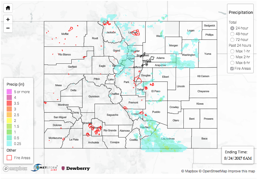
A weak upper-level disturbance moved over the northern Colorado yesterday afternoon. This contributed to more widespread coverage of the daily diurnal storms over the northern portion of the mountains. With light westerly flow over the state, most of the low-level moisture was mixed out except over the far eastern plains. Over the Southeastern Plains, a surface low set up in the afternoon that brought in moisture rich air on its east side. Dew points were in the low 60s over the far eastern plains. The thunderstorms never quite made it to the moisture rich air yesterday and with a quicker, southerly storm motion, but there was still a few impressive 24-hour totals.

Over the higher terrain yesterday, a UDFCD mesonet station in Boulder County captured 0.63 inches of rainfall and a station over Teller County recorded 0.83 inches. Most other stations over the high terrains recorded around 0.5 inches with radar estimates about the same. In Rosita, CO (Southeast Mountains), there was a report of 0.69 inches falling in a 15 minute duration. With this same storm there was a report of 0.5 inch hail. 1-hour estimated rain rates were as high as 1.5 inches with the largest storm total over Huerfano County. 1.5 inches of rain were estimated to have fallen over Colorado City where a CoCoRaHS station recorded 1.21 inches. Over Trinidad, a CoCoRaHS station recorded 0.91 inches and rainfall radar estimates were 1.5 inches just southeast of town. There were no flooding reports as of this morning.

To see how much rain fell in your neighborhood, scroll down and check out the State Precipitation Map below.

Click Here For Map Overview

The map below shows radar-estimated, rainfall gage-adjusted Quantitative Precipitation Estimates (QPE) across Colorado. The map is updated daily during the operational season (May 1 – Sep 30) by 11AM. The following six layers are currently available: 24-hour, 48-hour and 72-hour total precipitation, as well as maximum 1-hour, 2-hour and 6-hour precipitation over the past 24 hour period (to estimate where flash flooding may have occurred). The accumulation ending time is 6AM of the date shown in the bottom right corner. Also shown optionally are fire burn areas since 2012. The home button in the top left corner resets the map to the original zoom.

Note: We have identified a possible underestimation in QPE over the southwest part of the state. We are working to on this issue, and will provide an update as soon as possible.

SPM 08-23-2017: Strong Cap Produces Garden Variety Storms over the Higher Terrains

Issue Date: Wednesday, August 23, 2017
Issue Time: 10:55AM MDT

Summary:

The morning began with quite a bit of cloudiness over the state. This was expected to limit convection over the far eastern plains, which it did, but the cap was strong enough that storms that drifted into the immediate eastern, adjacent plains quickly dissipated. Only weak showers occurred over the eastern mountains. Over the western portion of the state, showers were more widespread in nature as they drifted from the higher terrain into the valleys with the support of the upper-level disturbance. Precipitable Water (PW) values were around 0.8 inches both east and west of the Continental Divide, which over the past two days had helped dropped impressive 1-hour rain rates (up to 1.5 inches). However, lower temperatures and increased cloud cover limited atmospheric instability and capped strong convection throughout the state. The weaker than expected lift from the shortwave was not able to break through this cap and tap into the higher dew points for heavy, local precipitation. Instead, garden variety showers occurred yesterday.

Over the San Juan Mountains, a CoCoRaHS station near Silverton recorded 0.51 inches for the 24-hour period. Most other storms produced between 0.1-0.3 inches with a few reports just under 1 inch in storm cores. A condensation funnel was even reported in Rio Blanco County. East of the Continental Divide, there were a handful of stations that recorded around 0.35 inches over the Front Range and Southeast Mountains. The radar estimated 1-hour rain rates were 0.5 inches. The highest 24-hour rainfall total was estimated just over 1 inch in Park County. There were no flooding reports yesterday as of this morning.

To see how much rain fell in your area, scroll down the State Precipitation Map below.

Click Here For Map Overview

The map below shows radar-estimated, rainfall gage-adjusted Quantitative Precipitation Estimates (QPE) across Colorado. The map is updated daily during the operational season (May 1 – Sep 30) by 11AM. The following six layers are currently available: 24-hour, 48-hour and 72-hour total precipitation, as well as maximum 1-hour, 2-hour and 6-hour precipitation over the past 24 hour period (to estimate where flash flooding may have occurred). The accumulation ending time is 6AM of the date shown in the bottom right corner. Also shown optionally are fire burn areas since 2012. The home button in the top left corner resets the map to the original zoom.

Note: We have identified a possible underestimation in QPE over the southwest part of the state. We are working to on this issue, and will provide an update as soon as possible.

SPM 08-22-2017: Slow Moving Storms Increase Flood Risk

Issue Date: Tuesday, August 22, 2017
Issue Time: 10:30AM MDT

Summary:

Monsoon moisture was on the increase again yesterday. The upper-level low pressure system over California paired with a broad high pressure center over Texas helped advect more moist air into the state. Storms favored the San Juan Mountains, southern Front Range and Southeast Mountains for the stronger thunderstorms. Slow steering winds under the ridge as well as Precipitable Water (PW) values near 0.8 inches helped increase the precipitation totals from the prior two days.

Over La Plata County, there was a storm report of heavy rain near Durango with 1.24 inches falling in 30-minutes. A SNOTEL site in the Southern San Juan Mountains near this area recorded 1.4 inches with 0.8 inches falling in an hour. Over the Front Range and Southeast Mountains, a CoCoRaHS station near Westcliffe recorded 0.7 inches. There were two Flash Flood Warnings over the Junkins and Hayden Pass Burn Scars, but no flooding was reported as of this morning. These burn scars will need to be monitored closely throughout the week as daily rainfall is expected. As the storms slowly moved south, a USGS precipitation gage reached 0.63 inches over Delhi, CO with radar total estimates just over 1.5 inches. There were no reports of flooding yesterday.

For the solar eclipse yesterday, mostly clear skies were found around the state with exception to a few places over the Southeast Plains. As many of you probably noticed, temperatures dropped off quite a bit during the event. The decrease in irradiance caused as much as a 5F drop in temperature during the hour of the eclipse. The temperatures quickly rebounded within the next hour.

To see how much rain fell in your area, scroll down the State Precipitation Map below.

Click Here For Map Overview

The map below shows radar-estimated, rainfall gage-adjusted Quantitative Precipitation Estimates (QPE) across Colorado. The map is updated daily during the operational season (May 1 – Sep 30) by 11AM. The following six layers are currently available: 24-hour, 48-hour and 72-hour total precipitation, as well as maximum 1-hour, 2-hour and 6-hour precipitation over the past 24 hour period (to estimate where flash flooding may have occurred). The accumulation ending time is 6AM of the date shown in the bottom right corner. Also shown optionally are fire burn areas since 2012. The home button in the top left corner resets the map to the original zoom.

Note: We have identified a possible underestimation in QPE over the southwest part of the state. We are working to on this issue, and will provide an update as soon as possible.

SPM 08-21-2017: Start of the Next Monsoon Surge

Issue Date: Monday, August 21, 2017
Issue Time: 10:15AM MDT

Summary:

An increase in moisture over the southern portion of the state yesterday help initiate more scattered showers and cloud cover over the higher terrain. A plume of monsoon moisture and convection from AZ and NM began advecting into the area. The areas that received the most increase in Precipitable Water (PW) were the Southeast Mountains, Raton and Palmer Ridge and San Juan Mountains. PW still remained quite a bit under what is considered high monsoon moisture, but none the less, the moisture return for the next round of monsoon storms has begun.

Only a couple significant thunderstorm affected the state yesterday, and they were located over the climatologically favored regions of Teller and La Plata County. A CoCoRaHS and USGS precipitation gage both recorded around 0.77 inches of rain for the event over the Palmer Ridge area. This was enough to prompt an Areal Flood Advisory, though no flooding had been reported this morning. Radar estimates for the storm total were as high as 2.0 inches. Over La Plata County, another CoCoRaHS station recorded 0.78 inches for the last 24-hour period. Elsewhere, general showers were producing between 0.1-0.2 inches of rainfall.

Cloudiness associated with the disturbance from the south moved over the SE corner of the state last night. These thicker clouds may not completely burn off by late this morning and may cause an obscured viewing of the eclipse today. There is currently a break in cloud cover over northern NM. The hope is that this will advect into southern Colorado this morning and allow a break in the clouds during the peak of the eclipse. However, if the timing isn’t perfect, ongoing convection over NM will cause partly cloudy skies over the southern portion of the state during the event.

To see how much precipitation fell in your neighborhood yesterday, scroll down the State Precipitation Map below.

Click Here For Map Overview

The map below shows radar-estimated, rainfall gage-adjusted Quantitative Precipitation Estimates (QPE) across Colorado. The map is updated daily during the operational season (May 1 – Sep 30) by 11AM. The following six layers are currently available: 24-hour, 48-hour and 72-hour total precipitation, as well as maximum 1-hour, 2-hour and 6-hour precipitation over the past 24 hour period (to estimate where flash flooding may have occurred). The accumulation ending time is 6AM of the date shown in the bottom right corner. Also shown optionally are fire burn areas since 2012. The home button in the top left corner resets the map to the original zoom.

Note: We have identified a possible underestimation in QPE over the southwest part of the state. We are working to on this issue, and will provide an update as soon as possible.