SPM 08-28-2017: Isolated Storms East, Heat Cranks Out West

Issue Date: Monday, August 28, 2017
Issue Time: 10:50AM MDT

Summary:

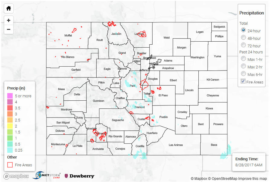
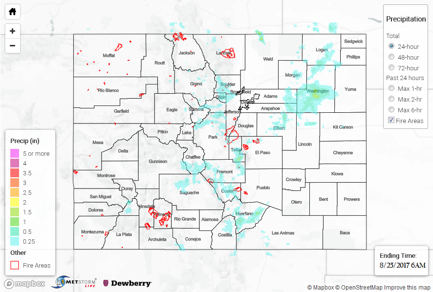
An upper-level ridge was established to the west of Colorado on Sunday, causing very warm temperatures west of the Continental Divide. Out east, plenty of sunshine made up for the marginal boundary layer moisture, supporting isolated thunderstorms across the climatologically favored parts of the western Palmer Ridge, Southeast Mountains, San Juans and San Luis Valley. The winners for highest rainfall amounts were (according to CoCoRaHS) Teller and Fremont counties with 0.78 and 0.54 inches, respectively. Other isolated locations received up to 0.5 inches. Even the normally dry San Luis Valley received some rainfall. A Flood Advisory was posted for the sensitive Hayden Pass burn scar during the afternoon. The Hayden Pass SNOTEL site received 0.2 inches as of this morning. Fortunately, no flooding was reported in the area, as of today.

Out west, high temperatures soared well into the 90s F for lower elevation locations below 5,000 feet. For example, Grand Junction got up to 97F, which is well above normal for this time of year.

For rainfall estimates in your area, check out our State Precipitation Map below.

Click Here For Map Overview

The map below shows radar-estimated, rainfall gage-adjusted Quantitative Precipitation Estimates (QPE) across Colorado. The map is updated daily during the operational season (May 1 – Sep 30) by 11AM. The following six layers are currently available: 24-hour, 48-hour and 72-hour total precipitation, as well as maximum 1-hour, 2-hour and 6-hour precipitation over the past 24 hour period (to estimate where flash flooding may have occurred). The accumulation ending time is 6AM of the date shown in the bottom right corner. Also shown optionally are fire burn areas since 2012. The home button in the top left corner resets the map to the original zoom.

Note: We have identified a possible underestimation in QPE over the southwest part of the state. We are working to on this issue, and will provide an update as soon as possible.

SPM 08-27-2017: Isolated Showers and Weak Thunderstorms Dotted the High Country

Issue Date: Sunday, August 27, 2017
Issue Time: 10:55 AM MDT

Summary:

Daytime heating and orographic effects battled a strengthening high pressure ridge over the Great Basin in a fight for Colorado weather supremacy yesterday. The high pressure ridge won the overall battle, keeping the vast majority of Colorado dry and warm yesterday. The August sun managed a few wins, however, as isolated showers/weak thunderstorms dotted the high country, resulting in mainly light rain and gusty outflow winds.

Flash flooding was not reported on Friday. For a look at precipitation estimates in your area, please see our State Precipitation Map below.

Click Here For Map Overview

The map below shows radar-estimated, rainfall gage-adjusted Quantitative Precipitation Estimates (QPE) across Colorado. The map is updated daily during the operational season (May 1 – Sep 30) by 11AM. The following six layers are currently available: 24-hour, 48-hour and 72-hour total precipitation, as well as maximum 1-hour, 2-hour and 6-hour precipitation over the past 24 hour period (to estimate where flash flooding may have occurred). The accumulation ending time is 6AM of the date shown in the bottom right corner. Also shown optionally are fire burn areas since 2012. The home button in the top left corner resets the map to the original zoom.

Note: We have identified a possible underestimation in QPE over the southwest part of the state. We are working to on this issue, and will provide an update as soon as possible.

SPM 08-26-2017: A Few Thunderstorms Rumbled

Issue Date: Saturday, August 26, 2017
Issue Time: 10:55 AM MDT

Summary:

The hot August sun battled the upper-level ridge to produce isolated showers and garden-variety thunderstorms yesterday. Most locations that received rainfall were treated to light accumulations of less than 0.1 inches. However, a convergence zone set up just to the east/southeast of the South Platte River in eastern Colorado, forcing a couple of strong thunderstorms to produce brief periods of moderate-to-heavy rainfall and pockets of hail. According to NWS local storm reports, 0.75 inch diameter hail was reported 9 miles ESE of Holyoke (Phillips County) and 1.0 inch diameter hail was reported 6 miles SE of Holyoke (Phillips County).

Flash flooding was not reported on Friday. For a look at precipitation estimates in your area, please see our State Precipitation Map below.

SPM 08-25-2017: Isolated Heavy Rainfall Across Eastern Plains

Issue Date: Friday, August 25, 2017
Issue Time: 11AM MDT

Summary:

With elevated moisture remaining across eastern Colorado on Thursday, scattered showers and thunderstorms were once again seen mainly east of the Continental Divide. Closer to the mountains, storms produced light to moderate rainfall, up to 0.91 inches in Gilpin County and 0.84 inches in Fremont County. Farther east, a few cells were a bit more impressive. In Washington County, a late afternoon slow-moving storm produced over 1.5 inches per hour (from radar estimates) and prompted an Areal Flood Advisory. In addition, hail up to 1 inch was reported. Another smaller storm produced over 1 inch of rainfall in an hour or less in Lincoln County, also prompting an Areal Flood Advisory.

West of the Continental Divide, conditions were generally quieter though light to moderate rainfall, in the form of showers and weak storms, was reported in the climatologically favored southern parts of the San Juan mountains and surrounding valleys. Amount of 0.25 to 0.5 inch range were common in La Plata and Montezuma counties, with slightly higher amounts up to 0.75 inches in the higher elevations.

Flooding was not reported on Thursday. For rainfall estimates in your area, check out our State Precipitation Map below.