SPM 08-13-2019: A Nice Break from Heavy Rainfall to Start the Week

Issue Date: Tuesday, August 13, 2019
Issue Time: 10:20AM MDT

Summary:

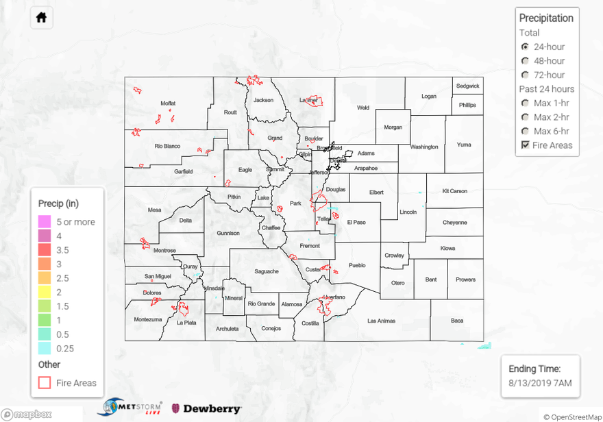
Westerly dry air and building high pressure really dried out the state yesterday after a week of persistent moderate to heavy rainfall. Dew points over the west dropped down into the teens and twenties as sunny skies and dry air mixed out a lot of the available surface moisture. Over the far eastern plains moisture was able to stick around a bit, but lack of support for severe weather kept the area from receiving any precipitation. There were a few areas along the foothills and Front Range that saw some light precipitation yesterday afternoon and early evening. Diurnal upslope flow was able to produce a storm or two over El Paso County, producing 24-hour totals around 0.25 inches. A CoCoRaHS station over Greeley in Weld County recorded 0.25 inches over 24-hours.

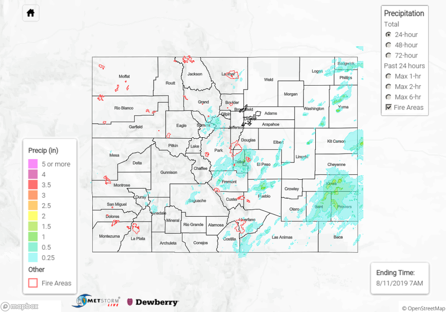
Back over the west, upslope flow of residual moisture lead to some weak thunderstorms over the eastern San Juan Mountains. A few rounds of small storms from 6PM to 8PM lead to accumulations between 0.12 and 0.31 inches over western and central Rio Grande County. One storm around 2PM yesterday lead to a 1.5-hour accumulation of 0.25 inches at a RAWS station to the east of Bayfield in Archuleta County. Ouray also reported a 24-hour total of 0.25 inches. Most of the rainfall over the San Juan Mountains was confined to the higher terrains, minus some minor spillover into the San Luis Valley. The rest of the western high country stayed mostly dry, with mild temperatures in the upper 70°Fs and 80°Fs.

For a look at precipitation over your area, please visit the State Precipitation Map below.

Click Here For Map Overview

The map below shows radar-estimated, rainfall gage-adjusted Quantitative Precipitation Estimates (QPE) across Colorado. The map is updated daily during the operational season (May 1 – Sep 30) by 11AM. The following six layers are currently available: 24-hour, 48-hour and 72-hour total precipitation, as well as maximum 1-hour, 2-hour and 6-hour precipitation over the past 24 hour period (to estimate where flash flooding may have occurred). The 24-hour, 48-hour and 72-hour total precipitation contain bias corrections that are not disaggregated into the hourly estimates, so there will likely be some differences. The accumulation ending time is 7AM of the date shown in the bottom right corner. Also shown optionally are vulnerable fire burn areas (post 2012), which are updated throughout the season to include new, vulnerable burn areas. The home button in the top left corner resets the map to the original zoom.

SPM 08-12-2019: Severe Thunderstorms and Giant Hail over the Northeast Plains

Issue Date: Monday, August 12, 2019
Issue Time: 9:35AM MDT

Summary:

All the ingredients were present over the Northeast Plains for severe thunderstorms yesterday and Mother Nature sure cashed in. High levels of instability, moisture and wind shear enabled slow moving thunderstorms to produce large hail, gusty winds, heavy rainfall and a few tornadoes. Storms began over the Front Range around noon and moved over the surrounding plains starting around 2PM yesterday, tracking to the east/northeast. One storm was capable of producing 4.5 inch diameter hail near Otis in Washington County, that’s grapefruit sized hail! Over 15 severe thunderstorm warnings were issued for storms over the eastern plains, along with 10 tornado warnings. In total there were 14 reports of hail, which ranged in size from 1 inch to 4.5 inches in diameter, and 6 reports of tornados. Rainfall was plentiful as well, with a CoCoRaHS station in central Yuma County measuring up to 2.28 inches of rain over the 24-hour period. Radar derived up to 2.5 inches over rain over the area, with rain up to 1.5 inches throughout the Northeast Plains. An Areal Flood Advisory was issued over northern Washington County yesterday but there were no reports of flooding in the area. Here are some of the notable storm reports given to the NWS yesterday:

  • 4 inch diameter hail was accompanied by a tornado near Otis in Washington County
  • 2.75 inch diameter hail and a tornado in western Yuma County with damage reported to a windshield
  • 1 inch diameter hail near Ponderosa Park in Elbert County
  • Thunderstorm wind damage caused downed power lines, roofs to be ripped off of houses and a steel building in a concrete base to be removed from the ground in Cheyenne County near Arapahoe

Back to the west there was moderate to high rainfall over the high country as well. The Flat Top Mountains had 24-hour accumulations on the higher end, with Dead Horse RAWS station measuring 0.8 inches in eastern Rio Blanco County. Radar derived up to 0.5 inches over the Northwest Slope and Northern Mountains. Heavy rainfall was reported all throughout the San Luis Valley and eastern San Juan Mountains. A CoCoRaHS station in Alamosa recorded up to 0.62 inches, which is very high for the area. To the west heavy rainfall reports increased to 1.7 inches in northeast Conejos County. A CoCoRaHS station near Durango measured 0.6 inches just to the south of the 416 burn area. No flooding was reported in Colorado Yesterday.

For a look at precipitation over your area, please visit the State Precipitation Map below.

Click Here For Map Overview

The map below shows radar-estimated, rainfall gage-adjusted Quantitative Precipitation Estimates (QPE) across Colorado. The map is updated daily during the operational season (May 1 – Sep 30) by 11AM. The following six layers are currently available: 24-hour, 48-hour and 72-hour total precipitation, as well as maximum 1-hour, 2-hour and 6-hour precipitation over the past 24 hour period (to estimate where flash flooding may have occurred). The 24-hour, 48-hour and 72-hour total precipitation contain bias corrections that are not disaggregated into the hourly estimates, so there will likely be some differences. The accumulation ending time is 7AM of the date shown in the bottom right corner. Also shown optionally are vulnerable fire burn areas (post 2012), which are updated throughout the season to include new, vulnerable burn areas. The home button in the top left corner resets the map to the original zoom.

SPM 08-11-2019: Heavy Rainfall over Central and Eastern Colorado

Issue Date: Sunday, August 11, 2019
Issue Time: 10AM MDT

Summary:

Another round of heavy rainfall fell over El Paso, Pueblo and Teller Counties yesterday. A severe thunderstorm formed near and passed over Pueblo around 6PM, producing a 76 mph wind gust at Pueblo Memorial Airport. Heavy rainfall was reported to the NWS around the same time, with measurements between 0.62 and 1.0 inches over the city. The heavy rainfall caused the Arkansas River gage near Avondale to rise 2 feet into Action stage (shown below) over a 4 hour period, however waters have since then retreated back below Action stage. A little farther to the north a trained spotter reported heavy rainfall of 0.6 inches over Colorado Springs from as storm that moved off the higher terrain to the west. CoCoRaHS stations throughout Teller County reported 24-hour totals between 0.77 and 1.65 inches over the eastern and south-central portions of the county. A Flash Flood Warning was issued by the NWS over central Fremont County near Salida, with radar deriving up to 1 inch of rain over the area, however no flooding was reported. Up to 0.3 inches of rain fell over the Spring Creek burn area again yesterday, which issued an Areal Flood Advisory, but once again no flooding was reported.

Rainfall over the eastern plains favored the southeast, with a few isolated pockets of heavy rain over the Palmer Ridge and Northeast Plains as well. Storms were moving pretty fast to the east-northeast, but isolated storm totals were still impressive. Radar derived up to two inches of rainfall in an isolated storm over central Yuma County. CoCoRaHS stations issued three reports of heavy rainfall over Prowers and Bent Counties, with 24-hour totals measuring between 0.9 and 1.41 inches. Light rain fell throughout the Urban Corridor and Front Range as well, with CoCoRaHS stations measuring up to 0.32 inches in Larimer County near Fort Collins.

Over the west things were a little drier, with rainfall favoring the San Juan Mountains and Central Mountains. 24-hour totals in Archuleta County near Pagosa Springs had the highest total accumulation once again for the region, measuring 0.39 inches. Eastern and Central Saguache County had higher totals again today, measuring up to 0.42 inches. Alamosa saw rain for the third day in a row now, with CoCoRaHS measuring up to 0.1 inches. The Northwest Slope and Northern Mountains stay dry yesterday due to dry air intruding from the west.

For a look at precipitation over your area, please visit the State Precipitation Map below.

Click Here For Map Overview

The map below shows radar-estimated, rainfall gage-adjusted Quantitative Precipitation Estimates (QPE) across Colorado. The map is updated daily during the operational season (May 1 – Sep 30) by 11AM. The following six layers are currently available: 24-hour, 48-hour and 72-hour total precipitation, as well as maximum 1-hour, 2-hour and 6-hour precipitation over the past 24 hour period (to estimate where flash flooding may have occurred). The 24-hour, 48-hour and 72-hour total precipitation contain bias corrections that are not disaggregated into the hourly estimates, so there will likely be some differences. The accumulation ending time is 7AM of the date shown in the bottom right corner. Also shown optionally are vulnerable fire burn areas (post 2012), which are updated throughout the season to include new, vulnerable burn areas. The home button in the top left corner resets the map to the original zoom.

SPM 08-10-2019: Flash Flooding over El Paso and Pueblo Counties

Issue Date: Saturday, August 10, 2019
Issue Time: 10:10 AM MDT

Summary:

Upslope flow aided by a passing shortwave created heavy rainfall over El Paso and Pueblo Counties yesterday from 1PM to 5PM. A trained spotter reported heavy rainfall of 1.98 inches over the 4-hour period to the NW of Pinon in northern El Paso County. The heavy rainfall lead to two reports of flash flooding over the area, with part of Young Hollow Road washing out and high waters between 6 and 10 inches over the roadways in the area. Radar derived up to 2.5 inches of rain. Thankfully no injuries were reported within the flooded areas. A flash flood warning was also issued over the Spring Creek burn area around 4PM yesterday, with heavy rainfall over the southeast portion of the burn scar. A CoCoRaHS station on the southern edge of the burn area reported a 24-hour total of 0.85 inches, but two stations near and within the burn area reported only 0.23 and 0.42 inches, implying that the heaviest rainfall narrowly missed the burn area. There were no reports of flash flooding. The Denver metro area also saw some rainfall last night around 8PM, with an UDFCD Alert gage reporting 0.24 inches near Utah Park in Arapahoe County. Multiple rounds of weak storms to the east of Longmont recorded 0.34 inches around 8PM as well. CoCoRaHS stations near the area reported 24-hour totals up to 0.89 inches.

Back to the west heavier rainfall fell over the Southwest Slope and San Juan Mountains. Persistent storms over northern La Plata County produced two reports of heavy rainfall of 0.75 and 0.63 inches over and to the south of the 416 burn area. A flash flood warning was issued by the NWS over the 416 burn area, with emergency management reporting high flows in nearby canals and ditches. Another notable rain report came in from the Lujan RAWS station in NW Saguache County of 0.45 inches. Storms moving over the San Luis Valley produce rainfall again over the normally dry area, with 0.14 inches reported in Alamosa. Most other areas of the high country stayed dry yesterday, with only trace amounts reported over the 24-hour period.

For a look at precipitation over your area, please visit the State Precipitation Map below.

Click Here For Map Overview

The map below shows radar-estimated, rainfall gage-adjusted Quantitative Precipitation Estimates (QPE) across Colorado. The map is updated daily during the operational season (May 1 – Sep 30) by 11AM. The following six layers are currently available: 24-hour, 48-hour and 72-hour total precipitation, as well as maximum 1-hour, 2-hour and 6-hour precipitation over the past 24 hour period (to estimate where flash flooding may have occurred). The 24-hour, 48-hour and 72-hour total precipitation contain bias corrections that are not disaggregated into the hourly estimates, so there will likely be some differences. The accumulation ending time is 7AM of the date shown in the bottom right corner. Also shown optionally are vulnerable fire burn areas (post 2012), which are updated throughout the season to include new, vulnerable burn areas. The home button in the top left corner resets the map to the original zoom.